 view gallery view gallery SW3.1 km SW3.1 km
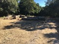
|   Thermes romains de Gaujac - France Thermes romains de Gaujac - France
in Wikipedia Entries Les thermes romains de Gaujac sont un complexe thermal d'époque romaine, situé sur le site antique de l'oppidum de Gaujac.
The Roman baths of Gaujac are a thermal complex of Roman times, located on the ancient site of the oppidum of Gaujac. posted by:  Alfouine Alfouine location: Occitanie, France date approved: 09/17/2017 last visited: never |
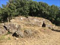
 view gallery view gallerySW3.1 km |  Le village médiéval de l'oppidum de Gaujac - France Le village médiéval de l'oppidum de Gaujac - France
in Ghost Towns Afin de profiter des pierres taillées dans anciens bâtiments de l'époque romaine, un village s'installe au Xème siècle.
In order to enjoy the stones carved in ancient buildings of the Roman era, a village settles in the Xth century. posted by: Alfouine location: Occitanie, France date approved: 09/26/2017 last visited: never |
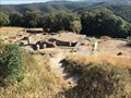
 view gallery view gallery W3.1 km W3.1 km
|  L'oppidum romain de Gaujac - France L'oppidum romain de Gaujac - France
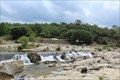
in Ancient Roman Civilization Situé sur une colline facile d'accès, le site a fait l'objet de nombreuses fouilles qui attestent l'importance de l'oppidum.
Located on an hill, the site has been the subject of numerous excavations which attest the importance of the oppidum. posted by: Alfouine location: Occitanie, France date approved: 09/17/2017 last visited: never |
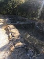 view gallery view galleryW3.1 km |  L'oppidum romain de Gaujac - France L'oppidum romain de Gaujac - France
in Preserved Architectural Remnants and Ruins Situé sur une colline facile d'accès, le site a fait l'objet de nombreuses fouilles qui attestent l'importance de l'oppidum.
Located on an hill, the site has been the subject of numerous excavations which attest the importance of the oppidum. posted by: Alfouine location: Occitanie, France date approved: 09/17/2017 last visited: never |
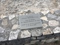
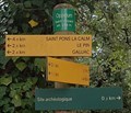 view gallery view galleryW3.1 km |  Au pied des portes de l'oppidum Saint-Vincent - Gaujac - France, 239 m. Au pied des portes de l'oppidum Saint-Vincent - Gaujac - France, 239 m.
in Elevation Signs [FR] Signalisation de lieu-dits et des villages près de l’oppidum fortifié de Gaujac dominant une vaste plaine où se rejoignent les Vallées de la Tave et de la Veyre. posted by: PaulLassiter location: Occitanie, France date approved: 09/08/2018 last visited: never |
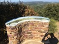 view gallery view galleryW3.4 km |  Le belvédère de la Gardie - Saint Pons la Calm - France Le belvédère de la Gardie - Saint Pons la Calm - France
in Orientation Tables Magnifique vue à 360° sur l'ensemble de la région du haut du belvédère de la Gardie.
Magnificent 360 ° view of the entire region from the top of the Gardie lookout. posted by: Alfouine location: Occitanie, France date approved: 09/17/2017 last visited: never |
 view gallery view gallery N9.7 km N9.7 km
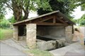
| ") Le Lavoir - Sabran, France Le Lavoir - Sabran, France
in Lavoir (wash houses) [EN] Le Lavoir is located at the eastern entrance of the hamlet of Donnat on the D143.
[FR] Le Lavoir se situe à l'entrée Est du hameau de Donnat au bord de la D143 posted by: pmaupin location: Occitanie, France date approved: 07/20/2017 last visited: 07/08/2017 |
 view gallery view gallery NE10.5 km NE10.5 km
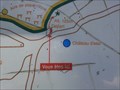
|  Fôret communale de Chusclan - Gard - France Fôret communale de Chusclan - Gard - France
in 'You Are Here' Maps Plan de 2 circuits dans la fôret sur les hauteurs de Chusclan
- Parcours de santé 1400m
- Sentier découverte 1600m posted by: JMRetSB location: Occitanie, France date approved: 08/02/2014 last visited: 08/13/2014 |
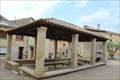 view gallery view galleryN10.6 km | Le Lavoir - Saint-Gervais, France in Lavoir (wash houses) [EN] Le Lavoir is located in Saint-Gervais small town located in the department of Gard, in Occitania region.
[FR] Le Lavoir se situe à Saint-Gervais petite commune située dans le département du Gard, en région Occitanie. posted by: pmaupin location: Occitanie, France date approved: 07/20/2017 last visited: 07/08/2017 |
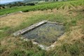
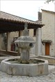 view gallery view galleryN10.8 km |  La Fontaine - Saint-Gervais, France La Fontaine - Saint-Gervais, France
in Fountains [EN] A fountain from 1767 feeds a washhouse with the waters of the sources of the Grand Font.
[FR] Une fontaine de 1767 alimente un lavoir avec les eaux des sources de la Grand Font. posted by: pmaupin location: Occitanie, France date approved: 07/22/2017 last visited: 07/09/2017 |
 view gallery view gallery NW12.4 km NW12.4 km
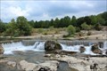
|  La Cèze et ses cascades - La-Roque-sur-Cèze, France La Cèze et ses cascades - La-Roque-sur-Cèze, France
in National Wild and Scenic Rivers [EN] The Cèze river has shaped a limestone plateau to give birth to the Cascades du Sautadet. [FR] La rivière Cèze a modelé un plateau de calcaire pour donner naissance aux Cascades du Sautadet. posted by: pmaupin location: Occitanie, France date approved: 05/20/2021 last visited: 11/10/2022 |
 view gallery view galleryNW12.4 km | Cascades du Sautadet - La-Roque-sur-Cèze, France in Wikipedia Entries [EN] The Cèze river has shaped a limestone plateau to give birth to the Cascades du Sautadet.
[FR] La rivière Cèze a modelé un plateau de calcaire pour donner naissance aux Cascades du Sautadet. posted by: pmaupin location: Occitanie, France date approved: 07/09/2017 last visited: 07/17/2017 |
 view gallery view galleryNW12.4 km |  Cascades du Sautadet - La-Roque-sur-Cèze, France Cascades du Sautadet - La-Roque-sur-Cèze, France
in Official Local Tourism Attractions [EN] The Cèze river has shaped a limestone plateau to give birth to the Cascades du Sautadet.
[FR] La rivière Cèze a modelé un plateau de calcaire pour donner naissance aux Cascades du Sautadet. posted by: pmaupin location: Occitanie, France date approved: 07/09/2017 last visited: 07/17/2017 |
 view gallery view galleryNW12.4 km |  Olivier Frances - La Roque sur Cèze - France Olivier Frances - La Roque sur Cèze - France
in Firefighter Memorials FRANCES Olivier, Lieutenant, 32 ans, mort le 21 avril 2000, disparition dans les eaux lors d'un sauvetage d'une fillette.
FRANCES Olivier, Lieutenant, 32 years old, died April 21, 2000, disappeared in the waters during a rescue of a girl. posted by: Alfouine location: Occitanie, France date approved: 09/20/2017 last visited: 11/10/2022 |
 view gallery view galleryN12.9 km | Le Lavoir du colombier - Saint-Michel-d' Euzet, France in Lavoir (wash houses) [EN] The lavoir du Colombier and its source are located below the chemin du Colombier on the edge of a vineyard.
[FR] Le lavoir du Colombier et sa source se trouvent en contrebas du chemin du Colombier au bord d'une vigne. posted by: pmaupin location: Occitanie, France date approved: 07/20/2017 last visited: 03/04/2021 |
 view gallery view galleryNW12.9 km | Pont Charles-Martel sur la Cèze - La Roque-sur-Cèze, France in Wikipedia Entries [EN] The Charles-Martel Bridge on the Cèze is a French bridge located in the village of La Roque-sur-Cèze.
[FR] Le Pont Charles-Martel sur la Cèze est un pont français situé dans le village gardois de La Roque-sur-Cèze. posted by: pmaupin location: Occitanie, France date approved: 07/10/2017 last visited: 08/08/2017 |
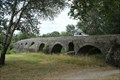 view gallery view galleryNW12.9 km |  Pont Charles-Martel sur la Cèze - La Roque-sur-Cèze, France Pont Charles-Martel sur la Cèze - La Roque-sur-Cèze, France
in Stone Bridges [EN] The Charles-Martel Bridge on the Cèze is a French bridge located in the village of La Roque-sur-Cèze.
[FR] Le Pont Charles-Martel sur la Cèze est un pont français situé dans le village gardois de La Roque-sur-Cèze. posted by: pmaupin location: Occitanie, France date approved: 07/22/2017 last visited: 08/08/2017 |
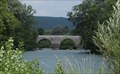 view gallery view galleryNW12.9 km |  Pont Charles-Martel sur la Cèze - La Roque-sur-Cèze, France Pont Charles-Martel sur la Cèze - La Roque-sur-Cèze, France
in Arch Bridges [EN] The Charles-Martel Bridge on the Cèze is a French bridge located in the village of La Roque-sur-Cèze.
[FR] Le Pont Charles-Martel sur la Cèze est un pont français situé dans le village gardois de La Roque-sur-Cèze. posted by: pmaupin location: Occitanie, France date approved: 07/10/2017 last visited: 08/08/2017 |
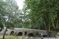 view gallery view galleryNW12.9 km |  Pont Charles-Martel sur la Cèze - La Roque-sur-Cèze, France Pont Charles-Martel sur la Cèze - La Roque-sur-Cèze, France
in Monuments Historiques Français [FR] Le Pont Charles-Martel sur la Cèze est un pont français situé dans le village gardois de La Roque-sur-Cèze.
[EN] The Charles-Martel Bridge on the Cèze is a French bridge located in the village of La Roque-sur-Cèze. posted by: pmaupin location: Occitanie, France date approved: 07/11/2017 last visited: 08/08/2017 |
 view gallery view galleryNW12.9 km | ") Le Pont dit "Charles-Martel" - La Roque-sur-Cèze, France Le Pont dit "Charles-Martel" - La Roque-sur-Cèze, France
in Histoires de France (French historical markers) [FR] Le Pont Charles-Martel sur la Cèze est un pont français situé dans le village gardois de La Roque-sur-Cèze. [EN] The Charles-Martel Bridge on the Cèze is a French bridge located in the village of La Roque-sur-Cèze. posted by: pmaupin location: Occitanie, France date approved: 05/20/2021 last visited: 07/09/2017 |
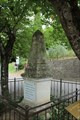 view gallery view galleryNW12.9 km |  Monument aux morts - La Roque-sur-Cèze - Gard - France Monument aux morts - La Roque-sur-Cèze - Gard - France
in World War I Memorials and Monuments [EN] War memorial in honor of soldiers who died in 1914/1918
[FR] Monument aux morts en l'honneur des soldats morts en 1914/1918 posted by: pmaupin location: Occitanie, France date approved: 07/27/2017 last visited: 07/08/2017 |
 view gallery view galleryNE12.9 km |  Chapelle Saint-Jean-Baptiste - Vénéjan, France Chapelle Saint-Jean-Baptiste - Vénéjan, France
in Romanesque Architecture [EN] The chapel Saint-Jean-Baptiste is an old parish church dating from the twelfth century and modified in the fourteenth and seventeenth centuries. [FR]La chapelle Saint-Jean-Baptiste est une ancienne église paroissiale datant du XIIe siècle et modifiée aux XIVe et XVIIe siècles. posted by: pmaupin location: Occitanie, France date approved: 07/14/2019 last visited: 07/07/2019 |
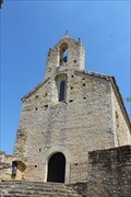 view gallery view galleryNE12.9 km | Chapelle Saint-Jean-Baptiste - Vénéjan, France in Wikipedia Entries [EN] The chapel Saint-Jean-Baptiste is an old parish church dating from the twelfth century and modified in the fourteenth and seventeenth centuries.
[FR]La chapelle Saint-Jean-Baptiste est une ancienne église paroissiale datant du XIIe siècle et modifiée aux XIVe et XVIIe siècles. posted by: pmaupin location: Occitanie, France date approved: 07/13/2019 last visited: 07/07/2019 |
 view gallery view galleryNE12.9 km |  Chapelle Saint-Jean-Baptiste - Vénéjan, France Chapelle Saint-Jean-Baptiste - Vénéjan, France
in Medieval Churches [EN] The chapel Saint-Jean-Baptiste is an old parish church dating from the twelfth century and modified in the fourteenth and seventeenth centuries. [FR]La chapelle Saint-Jean-Baptiste est une ancienne église paroissiale datant du XIIe siècle et modifiée aux XIVe et XVIIe siècles. posted by: pmaupin location: Occitanie, France date approved: 07/13/2019 last visited: 07/07/2019 |
 view gallery view galleryNE12.9 km |  Chapelle Saint-Jean-Baptiste - Vénéjan, France Chapelle Saint-Jean-Baptiste - Vénéjan, France
in Roman Catholic Churches [EN] The chapel Saint-Jean-Baptiste is an old parish church dating from the twelfth century and modified in the fourteenth and seventeenth centuries. [FR]La chapelle Saint-Jean-Baptiste est une ancienne église paroissiale datant du XIIe siècle et modifiée aux XIVe et XVIIe siècles. posted by: pmaupin location: Occitanie, France date approved: 07/14/2019 last visited: 07/07/2019 |
|