 view gallery view gallery E6.4 km E6.4 km
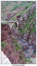
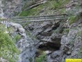
|   Pont de la mariée Pont de la mariée
in French Benchmarks Le pont de la mariée. posted by:  tontonlou tontonlou location: Provence-Alpes-Côte d'Azur, France date approved: 09/15/2013 last visited: 09/15/2013 |
 view gallery view gallery NW11.7 km NW11.7 km
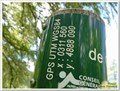
|  44°07'17.8"N 6°38'41.1"E - Cabane de Congerman - Beauvezer, France 44°07'17.8"N 6°38'41.1"E - Cabane de Congerman - Beauvezer, France
in Permanent Geographic Coordinates Ces coordonnées sont sur un panneau à destination des randonneurs posted by: YvesProvence location: Provence-Alpes-Côte d'Azur, France date approved: 06/12/2018 last visited: 09/05/2022 |
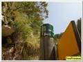
 view gallery view galleryNW11.9 km |  Fontaine de Congerman - Villars-Heyssier, Beauvezer, Paca, France Fontaine de Congerman - Villars-Heyssier, Beauvezer, Paca, France
in Fountains La fontaine du gîte de Congerman posted by: YvesProvence location: Provence-Alpes-Côte d'Azur, France date approved: 07/22/2017 last visited: 09/05/2022 |
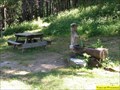
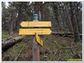
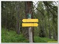 view gallery view galleryNW11.9 km |  Cabane de Congerman - Beauvezer, Paca, France Cabane de Congerman - Beauvezer, Paca, France
in Elevation Signs Un poteau de randonnée que l'on trouve derrière la cabane de Congerman, un bon endroit pour le pique-nique lors du tour des Gorges de St Pierre posted by: YvesProvence location: Provence-Alpes-Côte d'Azur, France date approved: 07/12/2017 last visited: 09/05/2022 |
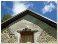 view gallery view galleryNW11.9 km | 1867 m - Cabanes forestières de Congerman - Beauvezer, France in Elevation Signs Une altitude présente au-dessus de la porte de la cabane principale de Congerman (il y en a 3). posted by: YvesProvence location: Provence-Alpes-Côte d'Azur, France date approved: 06/12/2018 last visited: 09/05/2022 |
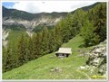
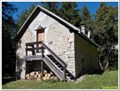 view gallery view galleryNW11.9 km |  Gite de Congerman - Villars-Heyssier, Beauvezer, Paca, France Gite de Congerman - Villars-Heyssier, Beauvezer, Paca, France
in Remote Backcountry Shelters Le Gîte de Congerman, au bout des gorges de Congerman. posted by: YvesProvence location: Provence-Alpes-Côte d'Azur, France date approved: 07/26/2017 last visited: 09/05/2022 |
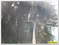
 view gallery view galleryNW12.4 km | 1907 m - Chabanal - Beauvezer, Paca, France in Elevation Signs Un poteau que l'on trouve en haut de la forêt, au nord du circuit de randonnée des Gorges de Saint Pierre, à la bifurcayion pour gagner la cabane de Chabanal. posted by: YvesProvence location: Provence-Alpes-Côte d'Azur, France date approved: 07/12/2017 last visited: 09/05/2022 |
 view gallery view galleryNW12.4 km | 44°07'38.5"N 6°38'27.8"E - Chabanal - Beauvezer, France in Permanent Geographic Coordinates Ces coordonnées sont sur un panneau à destination des randonneurs / These coordinates are on a sign for hikers posted by: YvesProvence location: Provence-Alpes-Côte d'Azur, France date approved: 09/05/2022 last visited: 09/05/2022 |
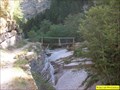 view gallery view galleryNW12.4 km |  Pont du fond des gorges de St Pierre, Beauvezer, Paca, France Pont du fond des gorges de St Pierre, Beauvezer, Paca, France
in Hiking Path Footbridges Au fond des gorges de Saint Pierre, on peu traverser le torrent par ce pont avec une seule rambarde. posted by: YvesProvence location: Provence-Alpes-Côte d'Azur, France date approved: 06/12/2017 last visited: 07/05/2019 |
 view gallery view galleryNW12.4 km |  Vous êtes ici - Ravin de Saint Pierre - Beauvezer, France Vous êtes ici - Ravin de Saint Pierre - Beauvezer, France
in 'You Are Here' Maps Un panneau destiné aux randonneurs posted by: YvesProvence location: Provence-Alpes-Côte d'Azur, France date approved: 06/12/2018 last visited: 07/05/2019 |
 view gallery view galleryNW12.4 km | 1561 m - Ravin de Saint Pierre - Beauvezer, Paca, France in Elevation Signs Un panneau d'information comme on en trouve sur les chemins de randonnées posted by: YvesProvence location: Provence-Alpes-Côte d'Azur, France date approved: 07/12/2017 last visited: 07/05/2019 |
 view gallery view galleryNW12.4 km | 44°07'19.8"N 6°38'10.9"E - Ravin de Saint Pierre - Beauvezer in Permanent Geographic Coordinates Ces coordonnées sont sur un panneau à destination des randonneurs posted by: YvesProvence location: Provence-Alpes-Côte d'Azur, France date approved: 08/16/2019 last visited: 09/05/2022 |
 view gallery view gallery W12.6 km W12.6 km
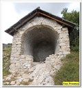
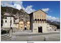
|  Chapelle Saint Barthélémy - Peyresq, Paca, France Chapelle Saint Barthélémy - Peyresq, Paca, France
in Roman Catholic Churches La Chapelle Saint Barthélémy de Peyresq posted by: YvesProvence location: Provence-Alpes-Côte d'Azur, France date approved: 08/10/2017 last visited: never |
 view gallery view galleryNW12.7 km | Maison forestière de Chabanal - Beauvezer, France in Remote Backcountry Shelters La cabane de Chabanal posted by: YvesProvence location: Provence-Alpes-Côte d'Azur, France date approved: 06/15/2018 last visited: never |
 view gallery view galleryE13 km |  Danger avion; Valberg, Alpes-Maritimes Danger avion; Valberg, Alpes-Maritimes
in Unusual Signs Beware of the aeroplanes posted by:  balista balista location: Provence-Alpes-Côte d'Azur, France date approved: 02/03/2010 last visited: 01/11/2011 |
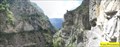 view gallery view galleryNW13.4 km |  Les gorges de Saint Pierre - Villars-Heyssier, Beauvezer, Paca, France Les gorges de Saint Pierre - Villars-Heyssier, Beauvezer, Paca, France
in Scenic Overlooks Les gorges de Saint Pierre, dans le haut Verdon posted by: YvesProvence location: Provence-Alpes-Côte d'Azur, France date approved: 06/25/2017 last visited: 07/05/2019 |
 view gallery view gallery S13.8 km S13.8 km
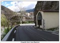
| Chapelle Saint Jean-Baptiste in French Benchmarks Support : CHAPELLE "SAINT-JEAN-BAPTISTE"
Partie support : MUR PIGNON ANTERIEUR, FACE ROUTE posted by: tontonlou location: Provence-Alpes-Côte d'Azur, France date approved: 04/24/2013 last visited: 04/24/2013 |
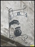 view gallery view galleryS14 km |  Tresor public - Entrevaux , France Tresor public - Entrevaux , France
in Unique Artistic Shop Signs L'enseigne du Trésor Public d'entrevaux posted by: YvesProvence location: Provence-Alpes-Côte d'Azur, France date approved: 03/06/2018 last visited: never |
 view gallery view galleryS14.2 km | Porte Royale in French Benchmarks Support : VIEUX PONT SUR LA RIVIERE "LE VAR"
Partie support : PORTE MONUMENTALE A L'ENTREE posted by: tontonlou location: Provence-Alpes-Côte d'Azur, France date approved: 04/24/2013 last visited: 11/10/2017 |
 view gallery view galleryNW14.2 km | Premier pont des gorges de St Pierre, Beauvezer, Paca, France in Hiking Path Footbridges Le pont du début du sentier des Gorges de Saint Pierre, au hameau de Villars-Heyssier, Beauvezer, Paca, France posted by: YvesProvence location: Provence-Alpes-Côte d'Azur, France date approved: 06/12/2017 last visited: 07/05/2019 |
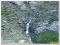 view gallery view galleryNW14.2 km |  Cascade du pont des Gorges de Saint Pierre - Beauvezer, France Cascade du pont des Gorges de Saint Pierre - Beauvezer, France
in Waterfalls Une cascade en trois parties posted by: YvesProvence location: Provence-Alpes-Côte d'Azur, France date approved: 06/12/2018 last visited: 07/05/2019 |
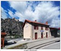 view gallery view galleryS14.2 km | Gare d'Entrevaux in French Benchmarks Support : GARE "D'ENTREVAUX"
Partie support : SOUBASSEMENT DU MUR DE FACADE , FACE VOIE posted by: tontonlou location: Provence-Alpes-Côte d'Azur, France date approved: 04/24/2013 last visited: 04/24/2013 |
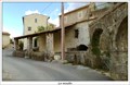 view gallery view galleryS14.2 km | Le moulin a farine in French Benchmarks Localisation : ATTENANT AU MOULIN A FARINE D'"ENTREVAUX"
Support : LAVOIR posted by: tontonlou location: Provence-Alpes-Côte d'Azur, France date approved: 04/24/2013 last visited: 04/24/2013 |
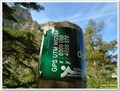 view gallery view galleryNW14.3 km | 44°07'31.4"N 6°36'49.1"E - Gorges de Saint Pierre - Beauvezer, France in Permanent Geographic Coordinates Ces coordonnées sont sur un panneau à destination des randonneurs posted by: YvesProvence location: Provence-Alpes-Côte d'Azur, France date approved: 06/12/2018 last visited: 09/05/2022 |
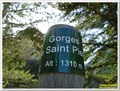 view gallery view galleryNW14.3 km | 1310 m - Gorges de Saint Pierre - Beauvezer, France in Elevation Signs Cette altitude est présente sur un panneau à destination des randonneurs posted by: YvesProvence location: Provence-Alpes-Côte d'Azur, France date approved: 06/12/2018 last visited: 09/05/2022 |
|