 view gallery view gallery SE5.5 km SE5.5 km
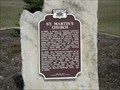
|   St. Martin's Church St. Martin's Church
in Wisconsin Historical Markers St Martins Church Marker North of New Holstein. posted by:  frankhj frankhj location: Wisconsin date approved: 04/19/2012 last visited: never |
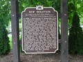 view gallery view gallerySE10.3 km | New Holstein in Wisconsin Historical Markers New Holstein Marker in New Holstein. posted by: frankhj location: Wisconsin date approved: 07/24/2007 last visited: never |
 view gallery view gallery W11.6 km W11.6 km
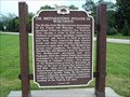
| Brothertown Indians of Wisconsin, The in Wisconsin Historical Markers Brothertown Indians Marker N. of Brothertown. posted by: frankhj location: Wisconsin date approved: 07/24/2007 last visited: 11/11/2011 |
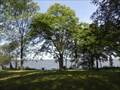
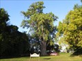 view gallery view galleryW12.1 km |  Lakeside Cemetery Cottonwood Lakeside Cemetery Cottonwood
in Exceptional Trees Probably the 4th largest tree in Wisconsin. posted by: Team Nut Tree location: Wisconsin date approved: 09/27/2012 last visited: never |
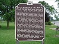 view gallery view galleryW14 km | Stockbridge Harbor in Wisconsin Historical Markers Stockbridge Harbor Marker on Lake Winnebago in Stockbridge. posted by: frankhj location: Wisconsin date approved: 07/24/2007 last visited: 09/26/2010 |
 view gallery view gallery NW15.8 km NW15.8 km
| Calumet County Park Hackberry in Exceptional Trees 8th largest Hackberry tree in Wisconsin. posted by: Team Nut Tree location: Wisconsin date approved: 09/26/2012 last visited: never |
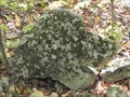 view gallery view galleryNW16.6 km |  Clifford the big stone dog Clifford the big stone dog
in Simulacra A large stone shaped like Clifford the big red dog. posted by: Team Nut Tree location: Wisconsin date approved: 09/25/2012 last visited: never |
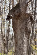 view gallery view galleryNW17.4 km | Warthog in Tree in Simulacra A warthog head and body appearing in a tree along a cliff hiking trail. posted by: ApprehendedLight location: Wisconsin date approved: 04/22/2010 last visited: never |
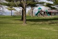 view gallery view galleryNW17.4 km |  High Cliff State Park Playground High Cliff State Park Playground
in Public Playgrounds High Cliff State Park playground located near the beach and lots of grassy areas. posted by: ApprehendedLight location: Wisconsin date approved: 04/22/2010 last visited: 10/09/2010 |
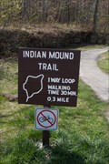 view gallery view galleryNW17.4 km |  Indian Mound Trail - High Cliff State Park - Wisconsin, USA Indian Mound Trail - High Cliff State Park - Wisconsin, USA
in Self Guided Walks and Trails Indian Mound Trail in High Cliff State Park in east central Wisconsin. The trail is a 0.3 mile loop at the top of a cliff around several Indian mounds. posted by: ApprehendedLight location: Wisconsin date approved: 05/05/2010 last visited: 10/09/2010 |
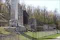 view gallery view galleryNW17.9 km |  Lime Kiln Ruins - High Cliff State Park, Wisconsin USA Lime Kiln Ruins - High Cliff State Park, Wisconsin USA
in Preserved Architectural Remnants and Ruins The ruins of a lime kiln, used between 1856-1956 to create "quick lime" that was used in cement, plaster and agriculture. All that remains now is parts of the 3 lime kilns. posted by: ApprehendedLight location: Wisconsin date approved: 05/04/2010 last visited: 09/25/2017 |
 view gallery view galleryNW17.9 km |  Lime Kiln Ruins, Sherwood Wisconsin, USA Lime Kiln Ruins, Sherwood Wisconsin, USA
in Ovens and Kilns The ruins of a lime kiln, used between 1856-1956 to create "quick lime" that was used in cement, plaster and agriculture. All that remains now is parts of the 3 lime kilns. posted by: ApprehendedLight location: Wisconsin date approved: 05/03/2010 last visited: 09/25/2017 |
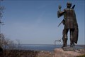 view gallery view galleryNW17.9 km |  Red Bird - Chief of the Winnebago Red Bird - Chief of the Winnebago
in Statues of Historic Figures Statue of Rid Bird, Chief of the Winnebago Tribe, overlooking the northeast end of Lake Winnebago, located in High Cliff State Park. posted by: ApprehendedLight location: Wisconsin date approved: 04/25/2010 last visited: 09/25/2017 |
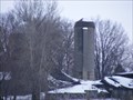
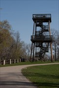 view gallery view galleryNW17.9 km |  High Cliff Observation Tower High Cliff Observation Tower
in Look-Out Towers Look-out tower at the top of the cliff at High Cliff State Park, overlooking the northeast shore of Lake Winnebago. posted by: ApprehendedLight location: Wisconsin date approved: 04/23/2010 last visited: 02/20/2012 |
 view gallery view gallery E19.3 km E19.3 km
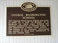
| George Washington School in Wisconsin Historical Markers George Washington School Marker in St. Nazianz. The property is listed in the Wisconsin State Register of Historic Place. posted by: frankhj location: Wisconsin date approved: 07/24/2007 last visited: never |
 view gallery view galleryE19.5 km | St. Nazianz in Wisconsin Historical Markers St. Nazianz Marker in St. Nazianz. posted by: frankhj location: Wisconsin date approved: 07/24/2007 last visited: never |
 view gallery view gallery SW19.8 km SW19.8 km
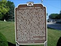
| Father Casper Rehrl in Wisconsin Historical Markers Father Casper Rehrl Marker in Johnsburg. This is kind of an oddity. There are 2 full size markers mounted back to back. The other side is not a Wisconsin Official Marker. The title is "St. John the Baptist Parish". posted by: frankhj location: Wisconsin date approved: 07/30/2007 last visited: 08/17/2009 |
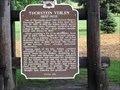 view gallery view galleryE23 km | Thorstein Veblen (1857-1929) in Wisconsin Historical Markers Thorstein Veblen Marker in Valders. posted by: frankhj location: Wisconsin date approved: 07/24/2007 last visited: 05/11/2009 |
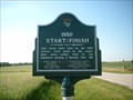 view gallery view gallerySE23.3 km |  Historic Race Circuits of Elkhart Lake 1950-1952 Historic Race Circuits of Elkhart Lake 1950-1952
in Racetracks The open road sports car races held in 1950-1952 were conceived and operated by members of the SCCA Chicago Region. The 1951-52 races drew international recognition and ultimately led to the establishment of Road America. Free Ride On The Roads. posted by:  Archived2012 Archived2012 location: Wisconsin date approved: 07/18/2007 last visited: never |
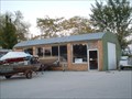 view gallery view gallerySE24.8 km |  Quonset Hut - Elkhart Lake, Wisconsin Quonset Hut - Elkhart Lake, Wisconsin
in Quonset Huts Step back in time. This Quonset Hut was once the 5th Wheel restaurant back in the 50's and 60's. posted by: Archived2012 location: Wisconsin date approved: 10/08/2007 last visited: never |
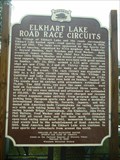 view gallery view gallerySE24.8 km | Elkhart Lake Road Race Circuits in Wisconsin Historical Markers Sports car racing legends Briggs Cunningham, Jim Kimberly, John Fitch, Phil Walters, Fred Wacker and Formula One world champion Phil Hill all raced here and left their mark. posted by: Archived2012 location: Wisconsin date approved: 06/04/2007 last visited: 07/27/2007 |
 view gallery view gallerySE25.1 km |  Elkhart Lake Road Race Circuits Elkhart Lake Road Race Circuits
in U.S. National Register of Historic Places The open road sports car races held in 1950-1952 were conceived and operated by members of the Chicago Region of the Sports Car Club of America (SCCA). The 51-52 races drew international recognition and led to the establishment of Road America. posted by: Archived2012 location: Wisconsin date approved: 08/07/2007 last visited: 06/20/2015 |
 view gallery view galleryNW26.9 km |  1735 S. Commercial Street Silo - Neenah, WI 1735 S. Commercial Street Silo - Neenah, WI
in Solitary Silos These are a pair silos around a collapsed barn. posted by: REUAHNESIE location: Wisconsin date approved: 01/31/2013 last visited: never |
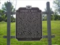 view gallery view gallerySW27 km | Edward S. Bragg in Wisconsin Historical Markers Edward S. Bragg marker at a Scenic Overlook N. of Fond du Lac. This Overlook is on the E. side of Lake Winnebago and the W. side of Lake Winnebago can be seen from it. posted by: frankhj location: Wisconsin date approved: 07/24/2007 last visited: 09/06/2009 |
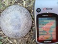 view gallery view galleryNW27 km |  Winnebago County Witness Mark No.4 Winnebago County Witness Mark No.4
in U.S. Benchmarks Aluminium Disk level with the ground posted by: Merc Inc. location: Wisconsin date approved: 05/23/2013 last visited: never |
|