 view gallery view gallery NW0.2 km NW0.2 km
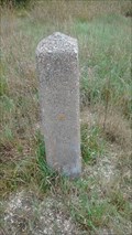
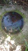
|   Camp McCoy Monument No 12 - Fort McCoy, WI Camp McCoy Monument No 12 - Fort McCoy, WI
in U.S. Historic Survey Stones and Monuments Barely readable, this obelisk marked the border of Fort McCoy when Highway 21 was improved and expanded in 1940-1941. posted by:  mrjcanger mrjcanger location: Wisconsin date approved: 10/05/2016 last visited: never |
 view gallery view gallery E0.6 km E0.6 km
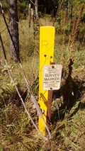
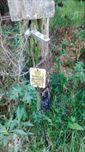
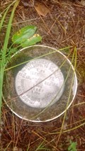
|  21802282000 Witness Post (Monroe County Survey) - Greenfield Township, WI, USA 21802282000 Witness Post (Monroe County Survey) - Greenfield Township, WI, USA
in Public Land Survey Marks This post bares witness to a railroad spike in the road which marks the West Quarter Corner of Section 27. posted by: mrjcanger location: Wisconsin date approved: 09/16/2016 last visited: never |
 view gallery view gallery W1 km W1 km
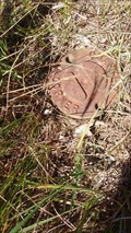
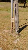
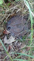
| 21802292000 Quarter Corner (Monroe County Survey) - Greenfield Township, WI, USA in Public Land Survey Marks Near three different witness posts for two different surveys, this Harrison marks the West Quarter Corner for Section 28. posted by: mrjcanger location: Wisconsin date approved: 09/20/2016 last visited: never |
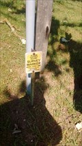
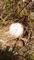 view gallery view galleryW1 km | Fort McCoy Boundary Dig Monument 1317.52 - Greenfield Township, WI, USA in Public Land Survey Marks Near three witness markers which bare witness to two surveys, this dig monument was placed in 2013 to mark the boundary of Fort McCoy, WI. posted by: mrjcanger location: Wisconsin date approved: 09/20/2016 last visited: never |
 view gallery view gallery N1 km N1 km
| 21802210020 South Quarter Corner (Monroe County Survey) - Greenfield Township, WI, USA in Public Land Survey Marks Marked with a witness post on the Northwest side of a Fireworks Avenue 90 degree turn, this Harrison monument marks the South Quarter Corner of Section 21. posted by: mrjcanger location: Wisconsin date approved: 09/15/2016 last visited: never |
 view gallery view gallery NE1.1 km NE1.1 km
| 21802210000 Witness Post (Monroe County Survey) - Greenfield Township, WI, USA in Public Land Survey Marks Next to what seems like an old gate pole, this witness post is set to bare witness to a Harrison buried in the middle of this intersection. posted by: mrjcanger location: Wisconsin date approved: 09/16/2016 last visited: never |
 view gallery view galleryNE1.8 km | 21802220020 Witness Post (Monroe County Survey) - Greenfield Township, WI, USA in Public Land Survey Marks Marking the North Quarter Corner for Section 27, this witness post sits next to a post that use to be a sign post and the end of a fence line. It also has a cable and may have been used as a gate. posted by: mrjcanger location: Wisconsin date approved: 09/16/2016 last visited: never |
 view gallery view galleryN1.9 km | 21802212000 Witness Post (Monroe County Survey) - Greenfield Township, WI, USA in Public Land Survey Marks This is an amazing intersection with an oak living right in the middle of it. Right next to the oak are a few signs to include this witness post. posted by: mrjcanger location: Wisconsin date approved: 09/15/2016 last visited: never |
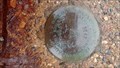
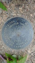
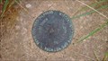
 view gallery view galleryNE1.9 km |  22 182W Monroe County Control Station - Greenfield Township, WI 22 182W Monroe County Control Station - Greenfield Township, WI
in U.S. Benchmarks Place for the Wisconsin County GPS Network, this disk is owned by the Wisconsin Department of Transportation and is marked by three orange witness posts. posted by: mrjcanger location: Wisconsin date approved: 09/16/2016 last visited: never |
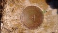
 view gallery view galleryW2.6 km | 1 FG Bench Mark Disk RESET - Fort McCoy, WI in U.S. Benchmarks This disk is a USGS RESET of an original disk placed in 1946. USGS falls under the Department of Interior posted by: mrjcanger location: Wisconsin date approved: 09/11/2016 last visited: never |
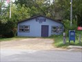 view gallery view galleryE4.5 km |  Tunnel City, WI 54662 Tunnel City, WI 54662
in U.S. Post Offices This is the US Post Office serving Tunnel City and the surrounding rural area. posted by:  REUAHNESIE REUAHNESIE location: Wisconsin date approved: 09/08/2012 last visited: 09/02/2016 |
 view gallery view galleryE4.5 km |  Ed Witt - Tunnel City, WI, USA Ed Witt - Tunnel City, WI, USA
in Citizen Memorials Found across the street from the Greenfield Town Hall, this park was dedicated to local Ed Witt. posted by: mrjcanger location: Wisconsin date approved: 09/07/2016 last visited: never |
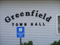 view gallery view galleryE4.5 km |  Greenfield, WI, USA Greenfield, WI, USA
in City and Town Halls The town of Greenfield is in Monroe County, WI, USA with a population of 707 as of the 2010 census. posted by: REUAHNESIE location: Wisconsin date approved: 12/21/2012 last visited: 09/02/2016 |
 view gallery view galleryE4.7 km | 3E47 Control Station - Tunnel City, WI in U.S. Benchmarks Located top of an abutment of a bridge which traverses a small creek, this disk was placed in 2004 by the Wisconsin Department of Transportation. posted by: mrjcanger location: Wisconsin date approved: 09/16/2016 last visited: never |
 view gallery view galleryW4.8 km | E-230 Metal Rod - Fort McCoy, WI in U.S. Benchmarks Found just off the South side of Hwy 21, near the main gate at Fort McCoy, this post is just feet from a power pole. posted by: mrjcanger location: Wisconsin date approved: 10/03/2016 last visited: never |
 view gallery view galleryW5.6 km | Camp McCoy Monument No 11 - Fort McCoy, WI in U.S. Historic Survey Stones and Monuments This concrete small standing obelisk dates back to 1940-41 when the state was building Highway 21 through Camp McCoy. posted by: mrjcanger location: Wisconsin date approved: 10/04/2016 last visited: never |
 view gallery view galleryW6 km | 3E46 Control Station - Fort McCoy, WI in U.S. Benchmarks This disk is located on Highway 21, on a box culvert traversing Stillwell Creek. posted by: mrjcanger location: Wisconsin date approved: 10/03/2016 last visited: never |
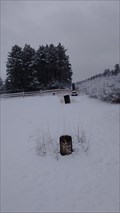
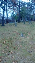 view gallery view galleryE6.1 km |  Boynton Family Cemetery - Tunnel City, WI, USA Boynton Family Cemetery - Tunnel City, WI, USA
in Worldwide Cemeteries This old family plot is located just South of Flint Avenue in Monroe County. The first recorded interment was in 1857. posted by: mrjcanger location: Wisconsin date approved: 12/02/2016 last visited: never |
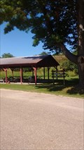
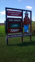 view gallery view galleryE6.6 km |  La Grange - Tomah, WI, USA La Grange - Tomah, WI, USA
in Smokey Bear Sign Sightings On Highway 21, just outside of the city limits of Tomah, WI sits the township of La Grange with Smokey watching over the nearby Fort McCoy Barrens State Natural Area. posted by: mrjcanger location: Wisconsin date approved: 09/27/2016 last visited: never |
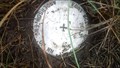
 view gallery view galleryW6.6 km | MCCOY Traverse Station Disk - Fort McCoy, WI in U.S. Benchmarks For being in an area that only sees Soldiers and hunters, this marker is in amazing shape. This part of Fort McCoy, WI is open to the public when training is not happening. posted by: mrjcanger location: Wisconsin date approved: 09/09/2016 last visited: never |
 view gallery view galleryNE7.1 km | LaGrange Cemetery - LaGrange Township, WI, USA in Worldwide Cemeteries Located just off of County Highway M in Monroe County, Wisconsin, this cemetery is home to two brothers who were killed in action less than four months apart during the American Civil War. posted by: mrjcanger location: Wisconsin date approved: 12/21/2016 last visited: never |
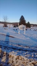
 view gallery view galleryW7.2 km | Lafayette Cemetery - Fort McCoy, WI, USA in Worldwide Cemeteries Predating North Post Fort McCoy, this cemetery was a local cemetery for the Lafayette township. posted by: mrjcanger location: Wisconsin date approved: 12/05/2016 last visited: never |
 view gallery view galleryE7.7 km | 29 181W Control Station - Tunnel City, WI in U.S. Benchmarks Located just off of Hwy 21, between Tunnel City and Tomah, this disk was placed in 1997 and is part of the Wisconsin County GPS Network. posted by: mrjcanger location: Wisconsin date approved: 09/28/2016 last visited: never |
 view gallery view galleryW7.9 km | Fort McCoy Boundary - Drive Monument 2005.01 - LaFayette Township, WI, USA in Public Land Survey Marks In 2013 Anderson Engineering of Minnesota was asked to survey the border of Fort McCoy, WI. This was an extensive task and this Drive Monument was one that was set for this survey. posted by: mrjcanger location: Wisconsin date approved: 09/14/2016 last visited: never |
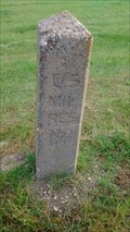
 view gallery view galleryW8 km | 21803270020 Quarter Corner (Monroe County Survey) - Lafayette Township, WI in Public Land Survey Marks Stamped with "QUARTER CORNER" this survey mark was placed in 1980 and marks the edge of Fort McCoy military base. posted by: mrjcanger location: Wisconsin date approved: 09/13/2016 last visited: never |
|