 view gallery view gallery SE4 km SE4 km
|   Vermontasaurus - Post Mills VT Vermontasaurus - Post Mills VT
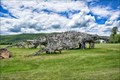
in Figurative Public Sculpture Brian Boland recruited volunteers to help him transform a pile of scrap wood into a huge junk dinosaur sculpture in 2010. There's a museum of junk as well. posted by:  nomadwillie nomadwillie location: Vermont date approved: 07/16/2017 last visited: never |
 view gallery view gallerySE4 km |  Vermontasaurus - Junk Dinosaur - Post Mills VT Vermontasaurus - Junk Dinosaur - Post Mills VT
in Roadside Attractions Brian Boland recruited volunteers to help him transform a pile of scrap wood into a huge junk dinosaur sculpture in 2010. There's a museum of junk as well. posted by: nomadwillie location: Vermont date approved: 07/15/2017 last visited: never |
 view gallery view gallerySE4 km |  Vermontasaurus - Post Mills VT Vermontasaurus - Post Mills VT
in Dinosaur Statues Brian Boland recruited volunteers to help him transform a pile of scrap wood into a huge junk dinosaur sculpture in 2010. There's a museum of junk as well posted by: nomadwillie location: Vermont date approved: 07/18/2017 last visited: never |
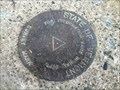 view gallery view gallerySE4.5 km |  State of Vermont Highway Dept Survey Mark - W side of Lake Fairlee State of Vermont Highway Dept Survey Mark - W side of Lake Fairlee
in U.S. Benchmarks A State of Vermont Highway Department Survey Mark (with no unique identification) located on the southeast abutment of the concrete bridge carrying Robinson Hill Road over Lake Fairlee. posted by: Jay-7 location: Vermont date approved: 05/06/2013 last visited: never |
 view gallery view gallery W6.4 km W6.4 km
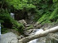
|  Old City Falls Old City Falls
in Waterfalls Beautiful local secret. Two tiered fall with a first drop of 25' and a second drop of 20'. posted by: rhythm112 location: Vermont date approved: 11/19/2007 last visited: never |
 view gallery view gallery N7.6 km N7.6 km
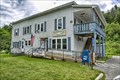
|  Vershire, VT 05079 Vershire, VT 05079
in U.S. Post Offices Located on Vermont 113 posted by: nomadwillie location: Vermont date approved: 07/19/2017 last visited: never |
 view gallery view gallery SW7.6 km SW7.6 km
|  Justin S. Morrill - Strafford, VT Justin S. Morrill - Strafford, VT
in Grave of a Famous Person Nineteenth century gentleman farmer Justin Smith Morrill was a long-time member of Congress best known for his Land-Grant College Acts. posted by: hykesj location: Vermont date approved: 02/12/2022 last visited: never |
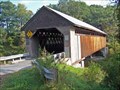
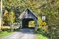
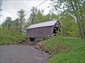
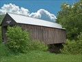
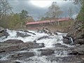 view gallery view gallerySE8.2 km |  Sayers Bridge Sayers Bridge
in Covered Bridges This bridge comes with a beautiful waterfall beneath. It is a wonderful place to have a picnic and enjoy this view. The truss is very unusual and has no duplicate in New England. posted by:  CoveredBridgeGuy CoveredBridgeGuy location: Vermont date approved: 01/27/2007 last visited: never |
 view gallery view gallery NE8.2 km NE8.2 km
| Albert Southworth - West Fairlee, VT in Grave of a Famous Person Grave of Albert Southworth, half of the famous nineteenth-century photographic firm Southworth & Hawes of Boston, Massachusetts. posted by: hykesj location: Vermont date approved: 05/09/2022 last visited: never |
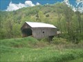
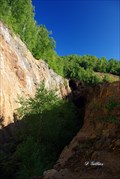 view gallery view gallery S9.3 km S9.3 km
|  Elizabeth Copper Mine Elizabeth Copper Mine
in Mines Abandoned open pit copper mine. posted by: DGillies location: Vermont date approved: 09/08/2009 last visited: never |
 view gallery view gallery E11.1 km E11.1 km
| Edgell Bridge in Covered Bridges This bridge has an unusual feature. U-shape piers are placed several feet from each end to help support this bridge which is south of Orford Village in Lyme, NH posted by: CoveredBridgeGuy location: New Hampshire date approved: 12/21/2008 last visited: never |
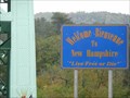 view gallery view galleryE12.6 km |  NH/VT on Hwy 25A NH/VT on Hwy 25A
in Border Crossings A quiet border crossing on Hwy 25A (Bridge St) between New Hampshire and Vermont. posted by: PeterNoG location: New Hampshire date approved: 12/12/2010 last visited: 10/03/2009 |
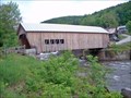
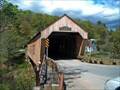 view gallery view galleryS12.7 km | Union Village Bridge in Covered Bridges This is the most beautiful (technically) bridge I have ever seen. It is a MUST SEE! The substructure consists of full lengthwise laminated beams. The builder kept the vintage look combined with the latest technology underneath. posted by: CoveredBridgeGuy location: Vermont date approved: 02/02/2007 last visited: never |
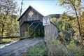
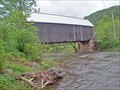 view gallery view galleryW13.8 km | Larkin Bridge in Covered Bridges Although this is typical of Vermont covered bridges in general, its uniqueness lies in that the bridge is perpendicular to the stream, but abutments are diagonal. posted by: CoveredBridgeGuy location: Vermont date approved: 01/02/2007 last visited: never |
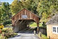
 view gallery view galleryW13.8 km |  Larkin Covered Bridge - North Tunbridge VT Larkin Covered Bridge - North Tunbridge VT
in U.S. National Register of Historic Places The Larkin Covered Bridge, built in 1902, it is one of the last documented covered bridges to be built in Vermont during the historic period of bridge construction, and is one of five covered bridges in the town. posted by: nomadwillie location: Vermont date approved: 10/04/2019 last visited: never |
 view gallery view gallery NW14.2 km NW14.2 km
| Flint Bridge in Covered Bridges This is one of six covered bridges within 7 miles. Vermont officials are considering by-passing this bridge. posted by: CoveredBridgeGuy location: Vermont date approved: 12/23/2006 last visited: never |
 view gallery view galleryNW14.2 km | Flint Covered Bridge - Tunbridge VT in U.S. National Register of Historic Places The Flint Covered Bridge is a historic covered bridge carrying Bicknell Hill Road over the First Branch White River in northern Tunbridge, Vermont. posted by: nomadwillie location: Vermont date approved: 10/04/2019 last visited: never |
 view gallery view galleryW14.5 km | Mill Bridge in Covered Bridges This is covered bridge territory - 7, all within a few miles of each other. Take a picnic lunch posted by: CoveredBridgeGuy location: Vermont date approved: 01/04/2007 last visited: 04/14/2008 |
 view gallery view galleryNW15 km | Moxley Covered Bridge - Chelsea VT in U.S. National Register of Historic Places The Moxley Covered Bridge, built in 1886-87, it is the town's only surviving 19th-century covered bridge. posted by: nomadwillie location: Vermont date approved: 10/04/2019 last visited: never |
 view gallery view galleryNW15 km | Moxley Bridge in Covered Bridges The quiet river valley along VT-110 is the home of 6 beautiful covered bridges. This is the northernmost of the six. posted by: CoveredBridgeGuy location: Vermont date approved: 01/06/2007 last visited: 07/06/2007 |
 view gallery view galleryW15.8 km | Mill Covered Bridge - Tunbridge VT in U.S. National Register of Historic Places The Mill Covered Bridge, was built in 2000, nearly replicating a previous structure built on the site in 1883 and lost due to ice damage. It is one of a high concentration of covered bridges in Tunbridge and Chelsea. posted by: nomadwillie location: Vermont date approved: 10/04/2019 last visited: never |
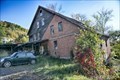 view gallery view galleryW15.8 km | Hayward and Kibby Mill - Tunbridge VT in U.S. National Register of Historic Places The Hayward and Kibby Mill, also known as the Tunbridge Mill, includes a substantially complete water-powered 19th-century grist mill dating back to 1820, with a later sawmill added about 1870. posted by: nomadwillie location: Vermont date approved: 10/04/2019 last visited: never |
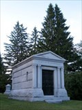
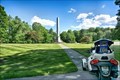 view gallery view gallerySW16.4 km | Birthplace of the Prophet Joseph Smith - South Royalton, VT in Roadside Attractions The granite monument is 52 feet tall and the shaft is 38.5 feet high, commemorating Smith's age at his death in Carthage, Illinois in 1844. Dedicated on December 23, 1905, the 100th anniversary of his birth. posted by: nomadwillie location: Vermont date approved: 05/20/2022 last visited: never |
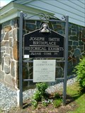 view gallery view gallerySW16.6 km |  Joseph Smith Birthplace - South Royalton, VT Joseph Smith Birthplace - South Royalton, VT
in LDS Church History Sites This waymark is located 2.5 miles along Dairy Hill Road after leaving Vermont route 14. posted by: elyob location: Vermont date approved: 07/13/2012 last visited: 05/01/2019 |
 view gallery view galleryW16.7 km | Howe Bridge in Covered Bridges This is a nicely maintained bridge connecting the Howe farm to the highway VT-110 posted by: CoveredBridgeGuy location: Vermont date approved: 01/02/2007 last visited: never |
|