 view gallery view gallery NW5.8 km NW5.8 km
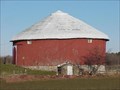
|   A Round Barn A Round Barn
in Odd-Shaped Buildings Still standing and in maintained condition, here's a round barn in an Amish area. posted by:  Hosta Hillbillys Hosta Hillbillys location: Michigan date approved: 01/12/2007 last visited: 05/05/2016 |
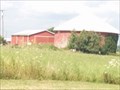 view gallery view galleryNW6 km |  Tripple F Farm - Osceola County, Michigan Tripple F Farm - Osceola County, Michigan
in Barns This round barn is found on the property of the Tripple F. Farm ousaide Evart, Michigan The address is 7328 Hwy 66. posted by:  GT.US GT.US location: Michigan date approved: 08/10/2015 last visited: 05/30/2018 |
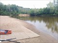 view gallery view gallery N8.7 km N8.7 km
|  Crawford Park Boat Ramp - Osceola County, Michigan Crawford Park Boat Ramp - Osceola County, Michigan
in Boat Ramps This ramp is used for launching boats into the Muskegon River. posted by: GT.US location: Michigan date approved: 08/13/2015 last visited: 05/05/2016 |
 view gallery view gallery W11.3 km W11.3 km
|  Smokey The Bear Sign - Evart DNR Office, Mi. Smokey The Bear Sign - Evart DNR Office, Mi.
in Smokey Bear Sign Sightings This Smokey The Bear sign is located near the Evart DNR Field Office outside Evart Michigan. posted by: Team_Watkins location: Michigan date approved: 07/30/2010 last visited: 05/30/2018 |
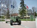 view gallery view galleryW12.4 km |  WWI Artillery Piece - Evart, MI WWI Artillery Piece - Evart, MI
in Military Ground Equipment Displays Located in Guyton Memorial Park on the northwest corner of 5th and Main Streets in Evart. There is street parking available. posted by: S5280ft location: Michigan date approved: 05/06/2007 last visited: 09/15/2016 |
 view gallery view galleryW12.4 km |  Joseph W. Guyton Joseph W. Guyton
in Michigan Historical Markers Located in Guyton Memorial Park on the northwest corner of 5th and Main Streets in Evart. There is street parking available. posted by: S5280ft location: Michigan date approved: 05/06/2007 last visited: 09/15/2016 |
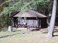 view gallery view galleryN12.7 km |  The Old Log Resort - Marion, Michigan The Old Log Resort - Marion, Michigan
in Chalet, Cottage, and Cabin Style Lodging Located on the north side of M-115, just past the Muskegon River, about 12.5 miles north of M-10. posted by: S5280ft location: Michigan date approved: 10/23/2007 last visited: 09/11/2018 |
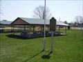
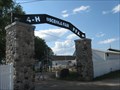 view gallery view galleryW13.4 km |  Osceola County Fairground, Evart MI. Osceola County Fairground, Evart MI.
in Agricultural Fairgrounds The Osceola County Fairgrounds is located in Evart MI. It hosts the annual fair the last week of July, every year. posted by: Team_Watkins location: Michigan date approved: 07/29/2010 last visited: 07/18/2009 |
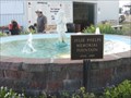 view gallery view galleryW13.4 km |  Julie Phelps Memorial Fountain - Evart Mi. Julie Phelps Memorial Fountain - Evart Mi.
in Fountains The Julie Phelps Memorial Fountain is located in the Osceola County Fairgrounds, Evart Michigan. posted by: Team_Watkins location: Michigan date approved: 07/29/2010 last visited: 07/13/2009 |
 view gallery view galleryW13.7 km |  Compass Rose - Evart, Mi. Compass Rose - Evart, Mi.
in Painted Barn Quilts The Compass Rose is located on the Evart Airport office off from US10. It is part of the Osceola County Barn Quilt Trail. posted by: Team_Watkins location: Michigan date approved: 11/06/2010 last visited: never |
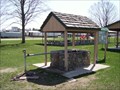 view gallery view gallery S13.8 km S13.8 km
|  Barryton Artesian Well - Barryton, MI Barryton Artesian Well - Barryton, MI
in Artesian Well Located in a wayside park on the east side of 30th Avenue (M-66), between Arthur and Rose Streets. Parking is available.
posted by: S5280ft location: Michigan date approved: 05/04/2007 last visited: 05/05/2016 |
 view gallery view galleryS14 km | Barryton/Frank Barry in Michigan Historical Markers Located in a wayside park on the east side of 30th Avenue (M-66), between Arthur and Rose Streets. Parking is available. posted by: S5280ft location: Michigan date approved: 05/04/2007 last visited: 07/02/2016 |
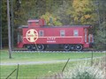 view gallery view gallery E14.6 km E14.6 km
|  Atchison, Topeka and Santa Fe Railway #999005 - Farwell, MI Atchison, Topeka and Santa Fe Railway #999005 - Farwell, MI
in Train Cabooses I want one of these on my front lawn. I'm not kidding. posted by: Team Farkle 7 location: Michigan date approved: 10/23/2009 last visited: 09/11/2018 |
 view gallery view galleryNW14.8 km | North Evart United Methodist Church in Michigan Historical Markers Located about 3 miles north of Evart on the southwest corner of 90th Street and 9 Mile Road. Streetside parking available. posted by: S5280ft location: Michigan date approved: 05/06/2007 last visited: 08/30/2021 |
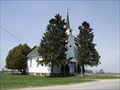 view gallery view galleryNW14.8 km |  North Evart United Methodist Church - Evart, MI North Evart United Methodist Church - Evart, MI
in This Old Church Located about 3 miles north of Evart on the southwest corner of 90th Street and 9 Mile Road. Streetside parking available.
posted by: S5280ft location: Michigan date approved: 05/06/2007 last visited: never |
 view gallery view galleryS16.6 km | Sherman City Union Church - Sherman City, MI in This Old Church Located on the southwest corner of West Vernon and Allen Roads. Streetside parking available. posted by: S5280ft location: Michigan date approved: 05/04/2007 last visited: 10/05/2016 |
 view gallery view galleryS16.6 km | Sherman City/Sherman City Union Church in Michigan Historical Markers Located on the southwest corner of West Vernon and Allen Roads. Streetside parking available. posted by: S5280ft location: Michigan date approved: 05/04/2007 last visited: 10/05/2016 |
 view gallery view galleryS16.6 km |  Sherman City Union Church - Sherman City, MI Sherman City Union Church - Sherman City, MI
in U.S. National Register of Historic Places Located on the southwest corner of West Vernon and Allen Roads. Streetside parking available. posted by: S5280ft location: Michigan date approved: 05/04/2007 last visited: 10/05/2016 |
 view gallery view galleryS16.6 km |  Sherman City Union Church - Sherman City, MI Sherman City Union Church - Sherman City, MI
in Relocated Structures Located on the southwest corner of West Vernon and Allen Roads. Streetside parking available. posted by: S5280ft location: Michigan date approved: 05/04/2007 last visited: 10/05/2016 |
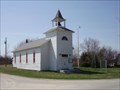 view gallery view galleryS16.6 km |  Sherman City, MI Sherman City, MI
in Ghost Towns Located on the southwest corner of West Vernon and Allen Roads. Streetside parking available. posted by: S5280ft location: Michigan date approved: 05/04/2007 last visited: 10/05/2016 |
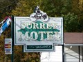 view gallery view galleryE17.7 km |  Surrey Motel - Farwell, MI Surrey Motel - Farwell, MI
in Neon Signs Vintage motel sign along US10. posted by: Team Farkle 7 location: Michigan date approved: 10/25/2009 last visited: 10/05/2016 |
 view gallery view galleryW23 km | Star of Bethlehem - Hersey, Mi. in Painted Barn Quilts The Star of Bethlehem quilt block is located near Hersey, Mi. on the McKay farm. It is part of the Osceola County Barn Quilt Trail. posted by: Team_Watkins location: Michigan date approved: 11/06/2010 last visited: never |
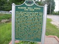 view gallery view galleryN25.7 km | Founding of Marion / Marion Mill Pond and Dam in Michigan Historical Markers A nice little roadside park here. posted by: Historic Markers location: Michigan date approved: 07/09/2014 last visited: 04/17/2016 |
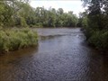 view gallery view galleryW25.9 km |  CONFLUENCE - Hersey River - Muskegon River CONFLUENCE - Hersey River - Muskegon River
in River Origins, Destinations and Confluences Confluence of the Hersey River and Muskegon River in Hersey MI. The confluence can be accessed easily via the Blodgett Landing campground or at the nature trail access point on 4th St. Waymark taken from the west confluence bank. posted by: Team_Watkins location: Michigan date approved: 08/21/2010 last visited: never |
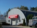 view gallery view galleryE26.7 km |  Snoopy's Towing - Clare, MI Snoopy's Towing - Clare, MI
in Quonset Huts Poor little beagle, must have rolled down the backside... posted by: Team Farkle 7 location: Michigan date approved: 10/22/2009 last visited: 12/22/2016 |
|