 view gallery view gallery SW3.9 km SW3.9 km
|   That “Mountain” Has Lost It’s Top! That “Mountain” Has Lost It’s Top!
in Oregon Historical Markers Sign at bulletin board for McGregor Memorial Viewpoint. posted by:  Volcanoguy Volcanoguy location: Oregon date approved: 07/03/2007 last visited: 07/18/2011 |
 view gallery view gallerySW3.9 km |  Don McGregor Memorial Viewpoint, Oregon Don McGregor Memorial Viewpoint, Oregon
in Scenic Roadside Look-Outs The Don McGregor Memorial Viewpoint is located 5 miles west of U.S. Hwy. 97 in La Pine State Park. posted by: Volcanoguy location: Oregon date approved: 07/02/2007 last visited: 07/18/2011 |
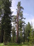 view gallery view gallery S4 km S4 km
|  Big Tree at La Pine State Park, Oregon Big Tree at La Pine State Park, Oregon
in Exceptional Trees The largest Ponderosa Pine in Oregon is located in La Pine State Park. posted by: Volcanoguy location: Oregon date approved: 07/04/2007 last visited: 06/10/2006 |
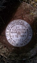
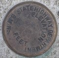 view gallery view galleryS4.2 km |  La Pine State Park Bridge BM, Oregon La Pine State Park Bridge BM, Oregon
in U.S. Benchmarks Benchmark cap on bridge in La Pine State Park. posted by: Volcanoguy location: Oregon date approved: 07/04/2007 last visited: 07/04/2007 |
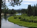 view gallery view galleryS4.8 km |  LaPine State Park - Oregon LaPine State Park - Oregon
in State/Provincial Parks La Pine State Park is located on the Deschutes River about 25 miles south of Bend, Oregon. posted by: Volcanoguy location: Oregon date approved: 07/02/2007 last visited: 10/23/2019 |
 view gallery view gallery E5 km E5 km
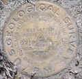
| USGS 'D2' BM - Deschutes County, OR in U.S. Benchmarks This 1908 USGS benchmark is located just off Huntington Drive in a small outcrop of rocks, in Deschutes County, OR. posted by: NW_history_buff location: Oregon date approved: 07/04/2012 last visited: never |
 view gallery view galleryE5.6 km | USGS 'DWR 1 1961' BM - Deschutes County, OR in U.S. Benchmarks This USGS benchmark is located near the junction of S Century Drive and Huntington Dr, next to a fence line, in Deschutes County, OR. posted by: NW_history_buff location: Oregon date approved: 07/04/2012 last visited: never |
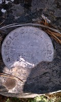
 view gallery view galleryE5.8 km | PB0226 - ODOT R 315, Oregon in U.S. Benchmarks NGS PID PB0226 - ODOT R 315 posted by: Volcanoguy location: Oregon date approved: 03/02/2007 last visited: 03/02/2007 |
 view gallery view gallery SE6 km SE6 km
| PB0672 - NGS C791, OR in U.S. Benchmarks National Geodetic Survey Vertical Control Point C791 posted by: Volcanoguy location: Oregon date approved: 06/20/2008 last visited: 06/21/2008 |
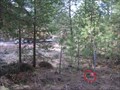
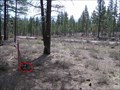
 view gallery view gallery W6.1 km W6.1 km
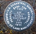
|  T20S R10E S31 T21S R9E S1 R10E S6 COR CC - Deschutes County, OR T20S R10E S31 T21S R9E S1 R10E S6 COR CC - Deschutes County, OR
in Public Land Survey Marks PLSS closing corner set by USDI-Bureau of Land Management in 1958; National Forest Survey Corner Visitation Card, Index File No. 0151 posted by: Cooke17513 location: Oregon date approved: 10/29/2013 last visited: never |
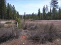
![Image for T20S R9E S36 R10E S31 [T21S R9E S1] COR SC - Deschutes County, OR](https://img.geocaching.com/waymarking/small/78d7316a-fd9d-41f4-8055-dee0deb7c3df.jpg) view gallery view galleryW6.3 km | T20S R9E S36 R10E S31 [T21S R9E S1] COR SC - Deschutes County, OR in Public Land Survey Marks PLSS standard corner set by USDI-Bureau of Land Management in 1958; National Forest Survey Corner Visitation Card, Index File No. 0175 posted by: Cooke17513 location: Oregon date approved: 10/29/2013 last visited: never |
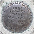
 view gallery view galleryE6.4 km | B532, Oregon in U.S. Benchmarks Oregon State Hwy. Dept. BM B532 posted by: Volcanoguy location: Oregon date approved: 04/27/2006 last visited: 04/28/2006 |
 view gallery view gallery N6.4 km N6.4 km
| GIS 0041, Oregon in U.S. Benchmarks Deschutes County GIS monument GIS 0041. posted by: Volcanoguy location: Oregon date approved: 04/27/2006 last visited: 04/28/2006 |
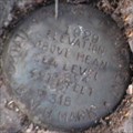
 view gallery view galleryN6.4 km | T 20 S, R 10 E, Sec. corner 1, 2, 11, 12, Oregon in U.S. Benchmarks Cap for T 20 S, R 10 E, Sec. corner 1, 2, 11, 12. posted by: Volcanoguy location: Oregon date approved: 04/27/2006 last visited: 04/28/2006 |
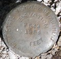 view gallery view gallerySE6.9 km | PB0671 - ODOT F532, OR in U.S. Benchmarks Oregon State Highway Department Benchmark F532 posted by: Volcanoguy location: Oregon date approved: 07/29/2008 last visited: 07/30/2008 |
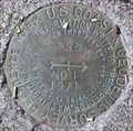
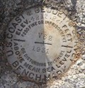 view gallery view galleryE6.9 km | PB0225 - USCGS V 62, Oregon in U.S. Benchmarks NGS PID PB0225 - USCGS V 62 posted by: Volcanoguy location: Oregon date approved: 03/02/2007 last visited: 03/06/2007 |
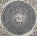
 view gallery view gallerySE7.4 km | PB0670 - USCGS CAREY, OR in U.S. Benchmarks US Coast & Geodetic Survey Triangulation Station CAREY posted by: Volcanoguy location: Oregon date approved: 06/23/2008 last visited: 06/23/2008 |
 view gallery view gallerySE7.4 km | PB0670 - USCGS CAREY NO 1, OR in U.S. Benchmarks US Coast & Geodetic Survey Reference Mark CAREY NO 1 posted by: Volcanoguy location: Oregon date approved: 06/23/2008 last visited: 06/23/2008 |
 view gallery view gallerySE7.4 km | PB0670 - USCGS CAREY NO 2, OR in U.S. Benchmarks US Coast & Geodetic Survey Reference Mark CAREY NO 2 posted by: Volcanoguy location: Oregon date approved: 06/23/2008 last visited: 06/23/2008 |
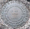 view gallery view gallerySE7.4 km | PB0230 - USCGS S62, OR in U.S. Benchmarks US Coast & Geodetic Survey Benchmark S62 posted by: Volcanoguy location: Oregon date approved: 06/23/2008 last visited: 06/30/2009 |
 view gallery view galleryE7.6 km | PB0674 - NGS E791, OR in U.S. Benchmarks National Geodetic Survey Vertical Control Point E791 posted by: Volcanoguy location: Oregon date approved: 06/20/2008 last visited: 06/21/2008 |
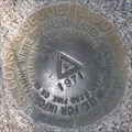
 view gallery view gallerySE8.4 km | PB0231 - USGS 4215.910, OR in U.S. Benchmarks US Coast & Geodetic Survey Benchmark 4215.910 posted by: Volcanoguy location: Oregon date approved: 06/23/2008 last visited: 06/23/2008 |
 view gallery view gallery NE8.4 km NE8.4 km
| PB0223 - ODOT Q315, OR in U.S. Benchmarks Oregon State Highway Department benchmark Q315 posted by: Volcanoguy location: Oregon date approved: 06/18/2008 last visited: 06/18/2008 |
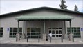
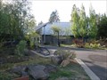 view gallery view galleryNE9 km |  Sunriver Area Public Library - Sunriver, Oregon Sunriver Area Public Library - Sunriver, Oregon
in Libraries The Sunriver Area Public Library serves the Sunriver Area between Bend and La Pine. posted by: Volcanoguy location: Oregon date approved: 11/22/2011 last visited: 11/19/2021 |
 view gallery view galleryNE9 km |  Bend, Oregon 97707 ~ Sunriver Station Bend, Oregon 97707 ~ Sunriver Station
in U.S. Post Offices This Post Office is located at 56857 Enterprise Drive in Bend, Oregon. posted by: brwhiz location: Oregon date approved: 12/21/2011 last visited: never |
|