 view gallery view gallery W4.8 km W4.8 km
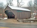
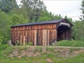
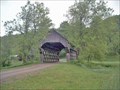
|   Riverside Farm Bridge Riverside Farm Bridge
in Covered Bridges Although this is not an authentic historic covered bridge, it is a well designed covered bridge. The builder designed his own truss. posted by:  CoveredBridgeGuy CoveredBridgeGuy location: Vermont date approved: 01/09/2007 last visited: 05/17/2008 |
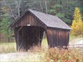 view gallery view gallery E10.8 km E10.8 km
| Barnard Bridge in Covered Bridges A nice little privately built and owned bridge over a beautiful brook. He did a nice job. posted by: CoveredBridgeGuy location: Vermont date approved: 12/14/2006 last visited: never |
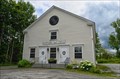 view gallery view gallery SE12.2 km SE12.2 km
|  Barnard, VT Barnard, VT
in City and Town Halls Located on N Rd Barnard Town Hall has the makings of a historical religious or educational building posted by:  nomadwillie nomadwillie location: Vermont date approved: 12/01/2015 last visited: never |
 view gallery view gallerySE12.4 km |  Historic Barnard - Barnard VT Historic Barnard - Barnard VT
in Vermont Historical Markers Located on the shore of Silver Lake across from the historic Barnard General Store. posted by: nomadwillie location: Vermont date approved: 01/03/2016 last visited: never |
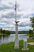 view gallery view gallerySE12.4 km |  Barnard Memorial - Barnard VT Barnard Memorial - Barnard VT
in Non-Specific Veteran Memorials Memorial is located on the shores of Silver Lake in the heart of Barnard VT posted by: nomadwillie location: Vermont date approved: 12/04/2015 last visited: never |
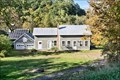
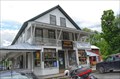 view gallery view gallerySE12.4 km |  Barnard General Store - Barnard VT Barnard General Store - Barnard VT
in The Local Neighborhood Grocer The Barnard General Store was established in 1832 and stands as one of the longest running General Stores in Vermont. posted by: nomadwillie location: Vermont date approved: 12/06/2015 last visited: never |
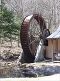 view gallery view gallery S13.7 km S13.7 km
|  Water Wheel Trading Post - Killington VT Water Wheel Trading Post - Killington VT
in Working Water Wheels This wheel is located at 4900 RT 4 in Killington VT posted by: nomadwillie location: Vermont date approved: 10/17/2009 last visited: 04/25/2009 |
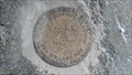 view gallery view galleryE16.6 km |  OD0287: 504 (USGS/NGS, Royalton, VT) OD0287: 504 (USGS/NGS, Royalton, VT)
in U.S. Benchmarks A USGS standard bench mark disk, located in Royalton, VT.
The NGS PID# is OD0287. posted by: NH2beers location: Vermont date approved: 10/11/2011 last visited: never |
 view gallery view galleryE16.6 km | DL8595: SILK (VTDH/NGS, Royalton, VT) in U.S. Benchmarks A VTHD standard bench mark disk, located in Royalton, VT.
The NGS PID# is DL8595. posted by: NH2beers location: Vermont date approved: 10/11/2011 last visited: 06/19/2013 |
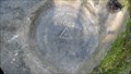 view gallery view galleryE16.7 km | DL8555: A00028 (VTDH/NGS, Royalton, VT) in U.S. Benchmarks A VTDH standard survey disk, located in Royalton, VT.
The NGS PID# is DL8555. posted by: NH2beers location: Vermont date approved: 10/11/2011 last visited: never |
 view gallery view gallery SW16.7 km SW16.7 km
| John Vincent - Mendon VT in Vermont Historical Markers This marker is on the side of Hwy 4 near Old Turnpike Rd. posted by: PeterNoG location: Vermont date approved: 10/09/2009 last visited: 03/07/2013 |
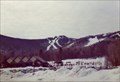 view gallery view galleryS16.7 km |  Killington Ski Area - Killington, VT Killington Ski Area - Killington, VT
in 1000 Places to See Before You Die Killington, in central Vermont, is the largest ski area in the eastern United States. posted by: hykesj location: Vermont date approved: 04/17/2022 last visited: never |
 view gallery view gallery NE18.5 km NE18.5 km
| Kingsbury Bridge in Covered Bridges This is one of several covered bridges in the local area - A good day's outing. posted by: CoveredBridgeGuy location: Vermont date approved: 01/02/2007 last visited: never |
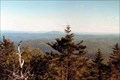 view gallery view galleryS19.5 km |  Killington Peak - Killington, Vermont Killington Peak - Killington, Vermont
in Mountain Summits Killington Peak, second highest summit in Vermont. posted by: Vermontish location: Vermont date approved: 06/20/2008 last visited: 07/24/2022 |
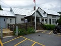
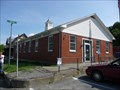 view gallery view galleryE19.8 km |  South Royalton, VT 05068 South Royalton, VT 05068
in U.S. Post Offices Located at 239 Chelsea Street South Royalton VT posted by: nomadwillie location: Vermont date approved: 05/17/2011 last visited: 06/25/2010 |
 view gallery view gallerySE20.4 km | Frank Lewis Bridge in Covered Bridges Frank Lewis, a farmer, wanted to get his farm animals across the stream, so he designed and built this unique bridge. The truss is a combination of a modified lattice between king post diagonals posted by: CoveredBridgeGuy location: Vermont date approved: 12/23/2006 last visited: never |
 view gallery view galleryE20.6 km |  Royalton Mill Complex - South Royalton VT Royalton Mill Complex - South Royalton VT
in U.S. National Register of Historic Places The Royalton Mill Complex is a three-building residential site in what is now a rural setting of Royalton, Vermont. posted by: nomadwillie location: Vermont date approved: 10/04/2019 last visited: never |
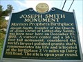 view gallery view galleryE20.8 km | Joseph Smith Monument - Royalton in Vermont Historical Markers The marker is located at the northeast corner of the intersection of Route 14 and Dairy Hill Road. The actual historical site is 2.5 miles along Dairy Hill Road. posted by: elyob location: Vermont date approved: 06/08/2012 last visited: 05/01/2019 |
 view gallery view galleryNE21.1 km | A00033 in U.S. Benchmarks A State of Vermont Highway Department benchmark located southeast of the intersection of VT Rt 14 and Dugout Road. posted by: Jay-7 location: Vermont date approved: 06/21/2013 last visited: never |
 view gallery view gallerySE21.1 km |  Suicide Six Ski Area Suicide Six Ski Area
in Winter Sports Locations A family ski area with something for everyone. posted by: Speeding Druid location: Vermont date approved: 06/04/2006 last visited: 09/29/2017 |
 view gallery view gallerySE21.7 km | Frank Smith Bridge in Covered Bridges 1973 - Mr. Twigg-Smith bought a 100 ft bridge and split it into 2 pieces. This is one of them - The other is the Twigg-Smith bridge, demolished in 2002 posted by: CoveredBridgeGuy location: Vermont date approved: 12/23/2006 last visited: never |
 view gallery view galleryS22.2 km | Bridgewater Corners, VT 05035 in U.S. Post Offices Located at 39 Vermont 100A, Bridgewater Corners, VT 05035 posted by: nomadwillie location: Vermont date approved: 03/13/2012 last visited: never |
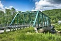 view gallery view galleryS22.4 km |  Bridgewater Corners Bridge - Bridgewater VT Bridgewater Corners Bridge - Bridgewater VT
in Truss Bridges The Bridgewater Corners Bridge carries Vermont Route 100A across the Ottauquechee River. It was built in 1928 by the American Bridge Company, following devastating flooding. It is a single-span Pratt through truss structure. posted by: nomadwillie location: Vermont date approved: 02/08/2023 last visited: never |
 view gallery view galleryS22.4 km | Bridgewater Corners Bridge - Bridgewater VT in U.S. National Register of Historic Places The Bridgewater Corners Bridge carries Vermont Route 100A across the Ottauquechee River in the Bridgewater Corners village of Bridgewater, Vermont. It was built in 1928 by the American Bridge Company, following devastating flooding. posted by: nomadwillie location: Vermont date approved: 02/10/2023 last visited: never |
 view gallery view galleryS22.4 km |  Bridgewater Corners Bridge - Bridgewater VT Bridgewater Corners Bridge - Bridgewater VT
in Wikipedia Entries The Bridgewater Corners Bridge carries Vermont Route 100A across the Ottauquechee River in the Bridgewater Corners village of Bridgewater, Vermont. It was built in 1928 by the American Bridge Company, following devastating flooding. posted by: nomadwillie location: Vermont date approved: 02/08/2023 last visited: never |
|