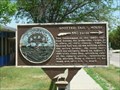
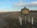
 view gallery view gallery SE9.7 km SE9.7 km
|   Spotted Tail's House Spotted Tail's House
in South Dakota Historical Markers Spotted Tail's house Historical Marker in Rosebud, SD posted by:  plainsdrifter358 plainsdrifter358 location: South Dakota date approved: 06/08/2006 last visited: 05/28/2006 |
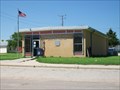 view gallery view gallery E19.6 km E19.6 km
|  Mission, South Dakota 57555 Mission, South Dakota 57555
in U.S. Post Offices Postoffice in a small town on the Rosebud Reservation. posted by: NGComets location: South Dakota date approved: 07/30/2011 last visited: never |
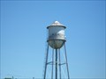 view gallery view galleryE22.4 km |  Watertower, Antelope, South Dakota Watertower, Antelope, South Dakota
in Water Towers Small community watertower. posted by: NGComets location: South Dakota date approved: 07/27/2011 last visited: never |
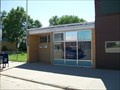 view gallery view gallery NE31.2 km NE31.2 km
| White River, South Dakota 57579 in U.S. Post Offices Small town post office. posted by: NGComets location: South Dakota date approved: 07/28/2011 last visited: never |
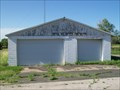
 view gallery view galleryNE31.2 km |  "American Legion Post 94" White River, South Dakota "American Legion Post 94" White River, South Dakota
in Legion Posts and Branches Named for two local men killed in WWI named Tom and Allen Otterman. posted by: NGComets location: South Dakota date approved: 12/04/2011 last visited: never |
 view gallery view gallery W40.1 km W40.1 km
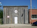
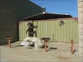
|  Vetal Volunteer Fire Dept. Vetal Volunteer Fire Dept.
in Firehouses Located on a wide spot in the road. posted by: NGComets location: South Dakota date approved: 07/27/2011 last visited: never |
 view gallery view galleryE42 km | Chauncey Eaglehorn War Memorial in South Dakota Historical Markers Eaglehorn WWI Memorial Stone along US Hwy 18 in Okreek, SD posted by: plainsdrifter358 location: South Dakota date approved: 06/08/2006 last visited: 05/28/2006 |
 view gallery view galleryE42 km | Okreek, South Dakota 57563 in U.S. Post Offices A post office sharing space with a community center. posted by: NGComets location: South Dakota date approved: 07/30/2011 last visited: never |
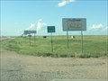 view gallery view gallerySE43.8 km |  South Dakota/Nebraska along US 83 South Dakota/Nebraska along US 83
in Border Crossings Border between South Dakota and Nebraska on US Highway 83. posted by:  Zaphody3k Zaphody3k location: Nebraska date approved: 10/15/2014 last visited: 06/27/2014 |
 view gallery view gallerySE47.3 km |  US Highway 83, Valentine, NE US Highway 83, Valentine, NE
in Blue Star Memorial Highway Markers A Blue Star Highway marker near Valentine, NE, on the "Blue Star Highway". posted by: Zaphody3k location: Nebraska date approved: 10/14/2014 last visited: 06/27/2014 |
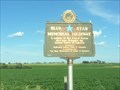
 view gallery view galleryW50.7 km | Civilian Conservation Corps Camp BF-3 in South Dakota Historical Markers Camp LaCreek built LaCreek National Wildlife Refuge near Tuthill, SD from May 1937 - Fall 1939 posted by: plainsdrifter358 location: South Dakota date approved: 12/06/2006 last visited: 06/19/2007 |
 view gallery view gallerySE56.2 km |  Multi-War Memorial, Cherry County, Valentine, NE Multi-War Memorial, Cherry County, Valentine, NE
in Non-Specific Veteran Memorials War Memorial on Main Street in Valentine, NE posted by: plainsdrifter358 location: Nebraska date approved: 06/06/2008 last visited: 06/29/2014 |
 view gallery view gallerySE56.3 km |  Welcome to Nebraska's Valentine Heart City Welcome to Nebraska's Valentine Heart City
in Welcome Signs Welcome to Valentine, NE posted by: plainsdrifter358 location: Nebraska date approved: 06/06/2008 last visited: never |
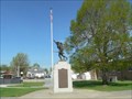
 view gallery view gallerySE56.5 km |  Land of the Buffalo Song Land of the Buffalo Song
in Figurative Public Sculpture Native American Hunter on Main Street in Valentine, NE posted by: plainsdrifter358 location: Nebraska date approved: 06/06/2008 last visited: never |
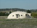 view gallery view gallerySE57.5 km |  Parked UFO Home, Valentine, NE Parked UFO Home, Valentine, NE
in Odd-Shaped Buildings Private home along NE Hwy 12 about 2 miles east of Valentine, NE posted by: plainsdrifter358 location: Nebraska date approved: 06/11/2008 last visited: never |
 view gallery view gallerySE59.4 km |  Fort Niobrara Fort Niobrara
in Nebraska Historical Markers Fort Niobrara, built in 1880 near Valentine, NE, was established to provide military protection of settlers in the region. posted by: plainsdrifter358 location: Nebraska date approved: 05/11/2008 last visited: 06/24/2009 |
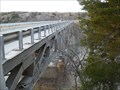
 view gallery view gallerySE59.7 km |  Borman Bridge - Valentine, NE Borman Bridge - Valentine, NE
in U.S. National Register of Historic Places Borman Bridge on Niobrara River near Valentine, NE posted by: plainsdrifter358 location: Nebraska date approved: 06/07/2008 last visited: 07/27/2009 |
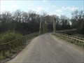 view gallery view gallerySE59.7 km |  Borman Truss Bridge on Niobrara River, Valentine, NE Borman Truss Bridge on Niobrara River, Valentine, NE
in Truss Bridges Borman Bridge on Niobrara River near Valentine, NE posted by: plainsdrifter358 location: Nebraska date approved: 06/09/2008 last visited: 06/24/2009 |
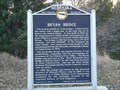 view gallery view gallerySE61.3 km | Bryan Bridge in Nebraska Historical Markers 1932 Bridge along old US 20 near Valentine crossing the Niobrara River. posted by: plainsdrifter358 location: Nebraska date approved: 11/13/2007 last visited: 10/21/2019 |
 view gallery view gallerySE61.3 km | Bryan Bridge - Valentine, NE in U.S. National Register of Historic Places Award winning 1932 Bridge along old US 20 near Valentine crossing the Niobrara River. posted by: plainsdrifter358 location: Nebraska date approved: 11/14/2007 last visited: 06/27/2014 |
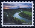 view gallery view gallerySE61.8 km |  Niobrara River, near Valentine, NE Niobrara River, near Valentine, NE
in Philatelic Photographs The Niobrara River in northern Nebraska was one of a dozen “Wild and Scenic” rivers featured on a set of U.S. postage stamps issued in 2019. posted by: hykesj location: Nebraska date approved: 06/15/2021 last visited: never |
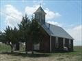 view gallery view gallery SW63.2 km SW63.2 km
|  The Wesleyan Church - NE The Wesleyan Church - NE
in Country Churches Small Wesleyan Church in the ghost town of Eli, NE. posted by: plainsdrifter358 location: Nebraska date approved: 05/12/2008 last visited: 04/11/2023 |
 view gallery view gallery N65 km N65 km
|  Belvidere Rest Area Belvidere Rest Area
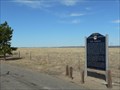
in Highway Rest Areas This Rest Area is located on the north side of Interstate Highway 90 at Milepost 166, about 3 miles east of Belvidere, South Dakota. posted by: brwhiz location: South Dakota date approved: 02/11/2013 last visited: 07/10/2016 |
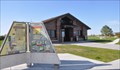
 view gallery view galleryN65 km |  Belvidere Westbound Rest Area Belvidere Westbound Rest Area
in 'You Are Here' Maps You Are Here at the Belvidere Rest Area on the north side of Interstate Highway 90 at milepost 167 about 3.6 miles east of Belvidere, South Dakota. posted by: brwhiz location: South Dakota date approved: 12/16/2012 last visited: never |
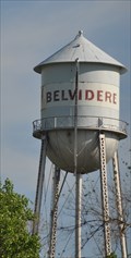 view gallery view gallery NW65 km NW65 km
|  OS0742 ~ BELVIDERE MUNICIPAL TANK OS0742 ~ BELVIDERE MUNICIPAL TANK
in U.S. Benchmarks This survey mark is the top center of the water tower located on the south side of B Street just southeast of the intersection with Main Street (South Dakota Highway 63) in Belvidere, South Dakota. posted by: brwhiz location: South Dakota date approved: 02/05/2013 last visited: never |
|