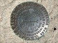
 view gallery view gallery NE17.5 km NE17.5 km
|   T40N R81W S9 S10 S15 S16 - Natrona County, Wyoming T40N R81W S9 S10 S15 S16 - Natrona County, Wyoming
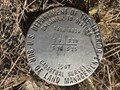
in Public Land Survey Marks A USDI-Bureau of Land Management section corner marker near the crest of a ridge on the edge of the Tisdale Anticline. posted by:  Tom.dog Tom.dog location: Wyoming date approved: 02/03/2024 last visited: never |
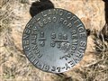
 view gallery view galleryNE19.2 km |  DUGOUT NO 2 - Natrona County, Wyoming DUGOUT NO 2 - Natrona County, Wyoming
in U.S. Benchmarks Reference mark 2 for triangulation station DUGOUT (OV0355). posted by: Tom.dog location: Wyoming date approved: 04/15/2024 last visited: never |
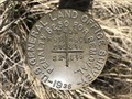
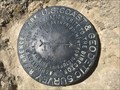
 view gallery view galleryNE19.2 km | DUGOUT (OV0355) - Natrona County, Wyoming in U.S. Benchmarks A triangulation station at the top of a relatively prominent hill near the southern end of the Tisdale Anticline. posted by: Tom.dog location: Wyoming date approved: 04/15/2024 last visited: never |
 view gallery view galleryNE19.2 km | DUGOUT NO 1 - Natrona County, Wyoming in U.S. Benchmarks Reference mark 1 for triangulation station DUGOUT (OV0355). posted by: Tom.dog location: Wyoming date approved: 04/15/2024 last visited: never |
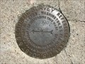
 view gallery view galleryNE19.2 km | T40N R81W S13 S24 R80W S18 S19 - Natrona County, Wyoming in Public Land Survey Marks This GLO section corner marker is set near the southern rim of an unnamed draw in the Tisdale Anticline. posted by: Tom.dog location: Wyoming date approved: 04/15/2024 last visited: never |
 view gallery view galleryNE19.6 km | DUGOUT AZIMUTH - Natrona County, Wyoming in U.S. Benchmarks The azimuth mark for triangulation station DUGOUT (OV0355). posted by: Tom.dog location: Wyoming date approved: 04/15/2024 last visited: never |
 view gallery view galleryNE19.6 km |  DUGOUT AZIMUTH - Natrona County, Wyoming DUGOUT AZIMUTH - Natrona County, Wyoming
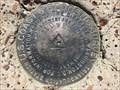
in Azimuth Benchmarks This azimuth mark for triangulation station DUGOUT (OV0355) is set on the southern end of the Tisdale Anticline in northeastern Natrona County. posted by: Tom.dog location: Wyoming date approved: 04/15/2024 last visited: never |
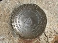
 view gallery view galleryNE19.6 km | T40N R80W S18 S19 1/4 - Natrona County, Wyoming in Public Land Survey Marks This GLO quarter corner mark is set near the crest of a ridge to the north of the Scott Creek drainage. posted by: Tom.dog location: Wyoming date approved: 04/15/2024 last visited: never |
 view gallery view galleryNE20.3 km | T40N R80W S18 S17 S20 S19 - Natrona County, Wyoming in Public Land Survey Marks A GLO section corner marker on the southern side of the Tisdale Anticline. posted by: Tom.dog location: Wyoming date approved: 04/15/2024 last visited: never |
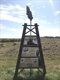 view gallery view gallery E33.8 km E33.8 km
|  Scandal!: Tempest at the Teapot - Teapot Dome, Wyoming Scandal!: Tempest at the Teapot - Teapot Dome, Wyoming
in Wyoming Historical Markers One of two historical markers at a pull-off along State Highway 259 that present history about the Salt Creek Oilfield, which was the site of a major U.S. oil scandal. posted by: Tom.dog location: Wyoming date approved: 08/27/2023 last visited: never |
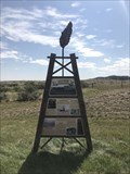 view gallery view galleryE33.8 km | Salt Creek: Producing Oil for over a Century - Teapot Dome, Wyoming in Wyoming Historical Markers One of two historical markers at a pull-off along State Highway 259 that present history about the Salt Creek Oilfield, which was the site of Wyoming's first oil boom. posted by: Tom.dog location: Wyoming date approved: 08/27/2023 last visited: never |
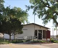 view gallery view galleryE34 km |  Midwest, Wyoming 82643 Midwest, Wyoming 82643
in U.S. Post Offices This Post Office is located at 132 Stock Street in Midwest, Wyoming. posted by: brwhiz location: Wyoming date approved: 07/02/2013 last visited: never |
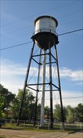 view gallery view galleryE34.1 km |  Midwest Water Tower Midwest Water Tower
in Water Towers This Water Tower is located on the west side of Ellison Avenue about halfway between Lewis Street and Stock Street in Midwest, Wyoming. posted by: brwhiz location: Wyoming date approved: 09/01/2013 last visited: 08/01/2015 |
 view gallery view galleryE34.4 km |  Midwest High School Time & Temperature Midwest High School Time & Temperature
in Time and Temperature Signs This Time and Temperature Sign is mounted on a stylized oil derrick on the northeast corner of Midwest High School at Lewis Street and Teachers Row in Midwest, Wyoming. posted by: brwhiz location: Wyoming date approved: 08/27/2013 last visited: never |
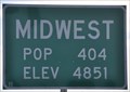
 view gallery view galleryE34.6 km |  Midwest, Wyoming ~ Elevation 4851 Feet Midwest, Wyoming ~ Elevation 4851 Feet
in Elevation Signs This combination Elevation/Population sign is on the southwest side of Wyoming Highway 387 at the northeastern town limits of Midwest, Wyoming. posted by: brwhiz location: Wyoming date approved: 07/25/2013 last visited: never |
 view gallery view galleryE34.6 km |  Midwest, Wyoming ~ Population 404 Midwest, Wyoming ~ Population 404
in Population Signs This combination Elevation/Population sign is on the southwest side of Wyoming Highway 387 at the northeastern town limits of Midwest, Wyoming. posted by: brwhiz location: Wyoming date approved: 07/25/2013 last visited: never |
 view gallery view galleryE34.8 km | MIDWEST AZI - Natrona County, Wyoming in Azimuth Benchmarks The cliff-edge azimuth mark for triangulation station MIDWEST (OV0346). posted by: Tom.dog location: Wyoming date approved: 07/05/2023 last visited: never |
 view gallery view galleryE34.8 km | MIDWEST AZI - Natrona County, Wyoming in U.S. Benchmarks This is the precariously-placed azimuth mark for triangulation station MIDWEST. posted by: Tom.dog location: Wyoming date approved: 05/08/2023 last visited: never |
 view gallery view galleryE34.9 km | MIDWEST NO 1 - Natrona County, Wyoming in U.S. Benchmarks Reference mark 1 for triangulation station MIDWEST. posted by: Tom.dog location: Wyoming date approved: 05/08/2023 last visited: never |
 view gallery view galleryE34.9 km | MIDWEST NO 2 - Natrona County, Wyoming in U.S. Benchmarks Reference mark 2 for triangulation station MIDWEST. posted by: Tom.dog location: Wyoming date approved: 05/08/2023 last visited: never |
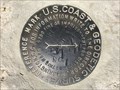
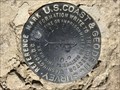
 view gallery view galleryE34.9 km | MIDWEST (OV0346) - Natrona County, Wyoming in U.S. Benchmarks Triangulation station MIDWEST is located at the top of a large butte to the south of the historic oil boom towns of Midwest and Edgerton. posted by: Tom.dog location: Wyoming date approved: 05/08/2023 last visited: never |
 view gallery view galleryE34.9 km | Midwest, Wyoming ~ Population 404 in Population Signs This combination Elevation/Population sign is on the north side of Wyoming Highway 387 at the eastern town limits of Midwest, Wyoming. posted by: brwhiz location: Wyoming date approved: 07/25/2013 last visited: never |
 view gallery view galleryE34.9 km | Midwest, Wyoming ~ Elevation 4851 Feet in Elevation Signs This combination Elevation/Population sign is on the north side of Wyoming Highway 387 at the eastern town limits of Midwest, Wyoming. posted by: brwhiz location: Wyoming date approved: 07/25/2013 last visited: never |
 view gallery view galleryE35.9 km | Edgerton, Wyoming ~ Elevation 5000 Feet in Elevation Signs This combination Elevation/Population sign is on the south side of Wyoming Highway 387 at the western town limits of Edgerton, Wyoming. posted by: brwhiz location: Wyoming date approved: 07/25/2013 last visited: never |
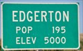 view gallery view galleryE35.9 km | Edgerton, Wyoming ~ Population 195 in Population Signs This combination Elevation/Population sign is on the south side of Wyoming Highway 387 at the western town limits of Edgerton, Wyoming. posted by: brwhiz location: Wyoming date approved: 07/25/2013 last visited: never |
|