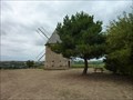
 view gallery view gallery NE7.4 km NE7.4 km
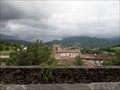
|   Le moulin de pesquies Le moulin de pesquies
in Windmills Le moulin à vent de Pesquies.
Restauré en 1991, il ne fonctionne plus. posted by:  niko_kristyn niko_kristyn location: Occitanie, France date approved: 07/31/2017 last visited: never |
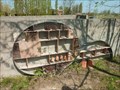 view gallery view gallery N18.2 km N18.2 km
|  L'hôtel à insectes de Lherm L'hôtel à insectes de Lherm
in Insect Hotels Magnifique hôtel à insectes posted by: niko_kristyn location: Occitanie, France date approved: 07/28/2017 last visited: never |
 view gallery view galleryN27 km |  IKEA Toulouse - France IKEA Toulouse - France
in IKEA IKEA store in Toulouse posted by:  Max93600 Max93600 location: Occitanie, France date approved: 10/07/2021 last visited: never |
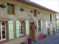 view gallery view galleryNE30.4 km |  Au Gré du Temps - Donneville, France Au Gré du Temps - Donneville, France
in Bed and Breakfast [FR] Blottie au coeur du village de Donneville, à 15 mn au sud-est de Toulouse, à 10 mn du métro-parking et à deux pas du canal du midi. [EN] Located in the heart of the village of Donneville, 15 minutes south-west of Toulouse. posted by: RakeInTheCache location: Occitanie, France date approved: 05/07/2012 last visited: never |
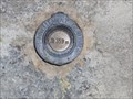
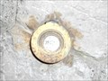
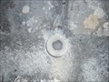 view gallery view gallery SW32 km SW32 km
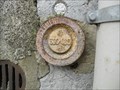
|  Benchmark - Petit pont - Caumont Benchmark - Petit pont - Caumont
in French Benchmarks Localisation : A 150 M AU NORD-EST DU CARREFOUR AVEC LA D.117
Support : PONT
Partie support : PARAPET AVAL, FACE ROUTE
Altitude : 354,400 m posted by: eolas location: Occitanie, France date approved: 02/21/2013 last visited: never |
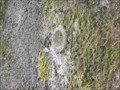
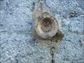
 view gallery view gallerySW32.2 km | Benchmark - l'Eglise - Caumont in French Benchmarks Support : EGLISE DE CAUMONT
Partie support : MUR DE FACADE ANTERIEUR, FACE SUD-OUEST, FACE ROUTE
Altitude : 359,171 m posted by: eolas location: Occitanie, France date approved: 02/21/2013 last visited: never |
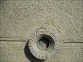
 view gallery view gallerySW32.8 km | Benchmark - Petit pont - Lorp in French Benchmarks Localisation : A 40 M AU SUD-EST DU CARREFOUR AVEC UN CHEMIN
Support : PONCEAU SUR LE MARCAZEAU
Altitude : 372,424 m posted by: eolas location: Occitanie, France date approved: 02/21/2013 last visited: never |
 view gallery view gallery S33 km S33 km
| Benchmark - LA PEYRADE - Lorp in French Benchmarks Localisation : AU LIEU-DIT "LA PEYRADE", AU NO 26, AVENUE CHARLES DE GAULLE
Altitude : 377,331 m posted by: eolas location: Occitanie, France date approved: 02/21/2013 last visited: 09/17/2009 |
 view gallery view galleryS33.2 km | Benchmark - EGLISE DE LORP in French Benchmarks Partie support : ABOUT DU TROISIEME CONTREFORT A COMPTER DE LA ROUTE, DANS LE MUR DE FACADE
ANTERIEUR
Altitude : 377,995 m posted by: eolas location: Occitanie, France date approved: 02/21/2013 last visited: never |
 view gallery view galleryS33.5 km |  Cathédrale Saint-Lizier - Saint-Lizier Cathédrale Saint-Lizier - Saint-Lizier
in Monuments Historiques Français Première cathédrale du village de Saint-Lizier avec son cloître roman, rare en Occitanie et le seul en Ariège. posted by: 09Naturel location: Occitanie, France date approved: 06/28/2018 last visited: 02/24/2020 |
 view gallery view galleryS33.5 km |  Cathédrale Saint-Lizier - Saint-Lizier Cathédrale Saint-Lizier - Saint-Lizier
in World Heritage Sites Première cathédrale du village de Saint-Lizier avec son cloître roman, rare en Occitanie et le seul en Ariège. posted by: 09Naturel location: Occitanie, France date approved: 06/28/2018 last visited: 02/24/2020 |
 view gallery view galleryS33.5 km |  Cathédrale Saint-Lizier - Saint-Lizier Cathédrale Saint-Lizier - Saint-Lizier
in Cathedrals Première cathédrale du village de Saint-Lizier avec son cloître roman, rare en Occitanie et le seul en Ariège. posted by: 09Naturel location: Occitanie, France date approved: 06/28/2018 last visited: 02/24/2020 |
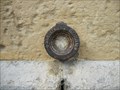
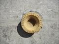
 view gallery view galleryS33.5 km | Benchmark - EE' - 43 BIS - Saint-Lizier in French Benchmarks Localisation : AU NORD-OUEST DU CARREFOUR GIRATOIRE AVEC LA D.33A
Support : MUR DE CLOTURE
*** Ce repère n'a pas été observé par l' I.G.N.
Altitude : 386,417 m posted by: eolas location: Occitanie, France date approved: 02/21/2013 last visited: never |
 view gallery view galleryS33.5 km |  Borne de recharge - Vigne de l'évêché, Saint-Lizier Borne de recharge - Vigne de l'évêché, Saint-Lizier
in Electric Car Charging Stations 2 points de charge disponibles, place Vigne de L'Eveche, d'une puissance de 22kW max chacun. posted by: 09Naturel location: Occitanie, France date approved: 06/27/2018 last visited: 02/24/2020 |
 view gallery view galleryNE34.3 km |  Ramonville - Toulouse, France Ramonville - Toulouse, France
in The Underground [FR] La station Ramonville est le terminus de la ligne B du métro de Toulouse. [EN] The Ramonville station is the terminus of line B of the Toulouse metro. posted by: RakeInTheCache location: Occitanie, France date approved: 05/07/2012 last visited: never |
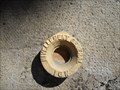
 view gallery view galleryS34.6 km | Benchmark - ANCIEN COLLEGE D'ENSEIGNEMENT TECHNIQUE in French Benchmarks Localisation : A SAINT-GIRONS, AU NO 28 DE L'AVENUE RENE PLAISANT
Support : MAISON (ANCIEN COLLEGE D'ENSEIGNEMENT TECHNIQUE)
Altitude : 390,435 m posted by: eolas location: Occitanie, France date approved: 02/21/2013 last visited: never |
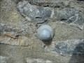
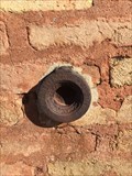
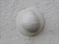 view gallery view galleryS34.8 km | Benchmark - L'ancienne gare - Saint-Girons in French Benchmarks Type : REPERE BOULE
Localisation : A 50 M A L'OUEST DE LA D.117
Support : GARE DE SAINT-GIRONS
Partie support : MUR DE FACADE DE L'AILE NORD, FACE VOIE FERREE
*** Ce repère n'a pas été observé par l' I.G.N.
Altitude : 391,720 m posted by: eolas location: Occitanie, France date approved: 02/20/2013 last visited: never |
 view gallery view galleryS34.9 km | Benchmark Pont neuf - Saint-Girons in French Benchmarks Localisation : A L'ANGLE SUD-OUEST DU SQUARE BALAGUE
Support : PONT SUR LE SALAT
Altitude : 390,329 m posted by: eolas location: Occitanie, France date approved: 02/21/2013 last visited: never |
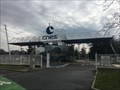 view gallery view galleryNE35.1 km |  Le CNES - Toulouse - France Le CNES - Toulouse - France
in Research Institutes Le site du Centre national d'études spatiales.
The site of the National Center for Space Studies. posted by: Alfouine location: Centre-Val-de-Loire, France date approved: 04/17/2018 last visited: 05/24/2022 |
 view gallery view galleryNE35.1 km |  Le CNES - Toulouse - France Le CNES - Toulouse - France
in Wikipedia Entries Le site du Centre national d'études spatiales.
The site of the National Center for Space Studies. posted by: Alfouine location: Occitanie, France date approved: 02/10/2018 last visited: never |
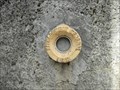
 view gallery view galleryN35.1 km | Repère de nivellement - Cimetière - Pujaudran, France in French Benchmarks Repère de nivellement sur le pilier Est du portail posted by: lynx36 location: Occitanie, France date approved: 04/27/2020 last visited: 02/19/2019 |
 view gallery view galleryS35.1 km | Benchmark L'église de Saint-Girons in French Benchmarks Localisation : A 190 M AU SUD DU CARREFOUR DE LA D.117 ET DE LA RUE DU MARCHE, PLACE DE VERDUN
Partie support : ABOUT DU 2EME CONTREFORT DU TRANSEPT GAUCHE A PARTIR DU CHOEUR, FACE A LA
PLACE, FACE NORD-OUEST
Altitude: 390.818 m. posted by: eolas location: Occitanie, France date approved: 02/20/2013 last visited: never |
 view gallery view galleryS35.2 km | Benchmark E.C.O3P3 - 1 - Saint-Girons in French Benchmarks Support : ECOLE PAUL SAINT-ALARY
Partie support : SOUBASSEMENT DU MUR DE FACADE SUD-OUEST, FACE PLACE
Altitude : 391,825 m posted by: eolas location: Occitanie, France date approved: 02/20/2013 last visited: never |
 view gallery view galleryS35.2 km | Benchmark E.C.O3P3 - 2 - Saint-Girons in French Benchmarks Localisation : AU CARREFOUR AVEC LE BOULEVARD PEYREVIDOL
Partie support : MUR DE FACADE SUD-OUEST, FACE RUE DESBIAUX
Altitude : 392,194 m posted by: eolas location: Occitanie, France date approved: 02/20/2013 last visited: never |
 view gallery view galleryS35.4 km | Benchmark - E.C.N3O3 - 37 - Saint-Girons in French Benchmarks Localisation : AU QUARTIER DE LEDAR, AU NO 19, AVENUE DU MARECHAL FOCH
Partie support : SOUBASSEMENT DU MUR PIGNON NORD-OUEST, FACE ROUTE
Altitude : 394,549 m posted by: eolas location: Occitanie, France date approved: 02/20/2013 last visited: never |
|