 view gallery view gallery N4.8 km N4.8 km
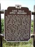
|   Gays Mills Apple Orchards Historical Marker Gays Mills Apple Orchards Historical Marker
in Wisconsin Historical Markers Gays Mills Apple Orchards Historical Marker on Hwy 171 1/2 mile east of Gays Mills, WI posted by:  onfire4jesus onfire4jesus location: Wisconsin date approved: 08/16/2007 last visited: 07/30/2007 |
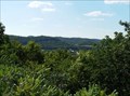 view gallery view galleryN4.8 km |  Gays Mills Wisconsin Overlook Gays Mills Wisconsin Overlook
in Scenic Roadside Look-Outs Gays Mills Wisconsin Overlook at wayside on Hwy 171 1/2 mile east of Gays Mills posted by: onfire4jesus location: Wisconsin date approved: 09/27/2007 last visited: 07/30/2007 |
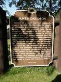 view gallery view gallery NE14 km NE14 km
| James Davidson Historical Marker in Wisconsin Historical Markers James Davidson Historical Marker posted by: onfire4jesus location: Wisconsin date approved: 08/16/2007 last visited: 10/03/2022 |
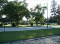 view gallery view galleryN14.5 km |  Beauford T. Anderson Memorial Park - Soldiers Grove, WI Beauford T. Anderson Memorial Park - Soldiers Grove, WI
in Municipal Parks and Plazas Beauford T. Anderson Memorial Park on Main St. in Soldiers Grove, Wisconsin posted by: onfire4jesus location: Wisconsin date approved: 07/30/2007 last visited: 03/31/2013 |
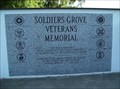 view gallery view galleryN14.6 km |  Soldiers Grove Veterans Memorial Soldiers Grove Veterans Memorial
in Non-Specific Veteran Memorials Soldiers Grove Veterans Memorial in Beauford T. Anderson Memorial Park in Soldiers Grove, Wisconsin posted by: onfire4jesus location: Wisconsin date approved: 08/02/2007 last visited: 03/31/2013 |
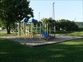 view gallery view galleryN14.6 km |  Beauford T. Anderson Memorial Park Playground Beauford T. Anderson Memorial Park Playground
in Public Playgrounds Beauford T. Anderson Memorial Park Playground on Main St in Soldiers Grove, Wisconsin posted by: onfire4jesus location: Wisconsin date approved: 07/30/2007 last visited: 03/31/2013 |
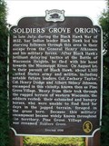 view gallery view galleryN14.6 km | Soldiers Grove Origin Historical Marker in Wisconsin Historical Markers Soldiers Grove Origin Historical Marker in Park at Mill and Main Sts. in Soldiers Grove, WI posted by: onfire4jesus location: Wisconsin date approved: 08/16/2007 last visited: 03/31/2013 |
 view gallery view gallery SE18 km SE18 km
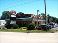
|  A&W - Boscobel, Wisconsin A&W - Boscobel, Wisconsin
in A + W Restaurants This is a cute restaurant in a cute town. posted by:  SageInThyme82 SageInThyme82 location: Wisconsin date approved: 08/14/2015 last visited: 06/11/2007 |
 view gallery view gallery W20 km W20 km
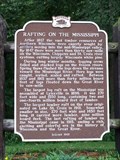
| Rafting on the Mississippi in Wisconsin Historical Markers Here logs were caught, sorted, scaled and rafted posted by: jcak1979 location: Wisconsin date approved: 08/06/2006 last visited: 10/20/2013 |
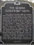 view gallery view gallerySE20.1 km | The Gideons - Boscobel, WI in Wisconsin Historical Markers This marker is located in a wayside a quarter mile south of Boscobel, WI. posted by: onfire4jesus location: Wisconsin date approved: 10/30/2008 last visited: 10/03/2022 |
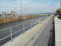
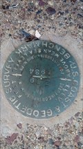
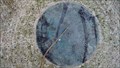
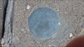 view gallery view galleryN20.4 km |  2S56 Control Station - Readstown, WI 2S56 Control Station - Readstown, WI
in U.S. Benchmarks Located on the Southeast wing wall of the bridge spanning the creek that flows from Spring Valley, this disk was set be the Wisconsin DOT in 2004 posted by: mrjcanger location: Wisconsin date approved: 10/14/2016 last visited: never |
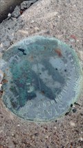 view gallery view galleryN20.4 km | Spring Valley Elevation Disk - Readstown, WI in U.S. Benchmarks Set on a bridge that spans the creek flowing from Spring Valley, this disk shows a small portion of Wisconsin's highway history. posted by: mrjcanger location: Wisconsin date approved: 10/14/2016 last visited: never |
 view gallery view galleryW22.4 km |  Mississippi River Lock and Dam No. 9 - Lynxville, WI Mississippi River Lock and Dam No. 9 - Lynxville, WI
in Waterway Locks, Planes and Lifts The Mississippi River Lock and Dam No. 9 is located along Highway 35 a couple of miles south of Lynxville, WI. It is part of the St. Paul district. posted by: onfire4jesus location: Wisconsin date approved: 10/16/2008 last visited: 10/12/2008 |
 view gallery view galleryN24.1 km | Green Acres Vertical Control - Franklin Township, WI in U.S. Benchmarks Placed on the top of the Southwest wing wall of a bridge traversing Reads Creek, this disk marks a very good place to catch brown trout. posted by: mrjcanger location: Wisconsin date approved: 10/07/2016 last visited: never |
 view gallery view gallery E25.9 km E25.9 km
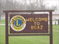
|  Boaz, Wi Boaz, Wi
in Names From the Bible The village of Boaz in Richland County, Wisconsin. Boaz married Ruth and was the father of Jesse, the father of King David posted by: onfire4jesus location: Wisconsin date approved: 04/30/2007 last visited: 08/07/2018 |
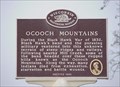 view gallery view galleryE26.1 km | Ocooch Mountains in Wisconsin Historical Markers Ocooch Mountains Historical Marker in Boaz Park on Hwy 171 in Boaz posted by: onfire4jesus location: Wisconsin date approved: 04/24/2007 last visited: 08/07/2018 |
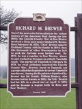 view gallery view galleryE26.1 km | Richard M. Brewer in Wisconsin Historical Markers Richard M. Brewer Historical Marker in Boaz Park on Hwy 171 in Boaz posted by: onfire4jesus location: Wisconsin date approved: 04/24/2007 last visited: 08/07/2018 |
 view gallery view gallery NW27 km NW27 km
|  Francis A Waller AKA Francis A. Wallar-Retreat, WI Francis A Waller AKA Francis A. Wallar-Retreat, WI
in Medal Of Honor Resting Places Civil War Medal of Honor Recipient for action at Gettysburg, PA on July 1, 1863. He is buried in Walnut Mound Cemetery, Retreat, WI in West Block, Lot 13. posted by: Don.Morfe location: Wisconsin date approved: 06/28/2019 last visited: 12/05/2021 |
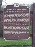 view gallery view galleryE28.2 km | Rural Electrification in Wisconsin Historical Markers Rural Electrification Historical Marker in wayside on Hwy 14 east of Boaz posted by: onfire4jesus location: Wisconsin date approved: 04/24/2007 last visited: 11/29/2022 |
 view gallery view galleryE28.2 km |  FIRST - Wisconsin farm with rural electrical power FIRST - Wisconsin farm with rural electrical power
in First of its Kind This farm was the first in Wisconsin to obtain central station electric power from a rural electric cooperative posted by: onfire4jesus location: Wisconsin date approved: 08/10/2007 last visited: 11/29/2022 |
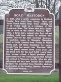 view gallery view galleryE28.2 km | Boaz Mastodon in Wisconsin Historical Markers Boaz Mastodon Historical Marker in wayside on Hwy 14 east of Boaz posted by: onfire4jesus location: Wisconsin date approved: 04/24/2007 last visited: 11/29/2022 |
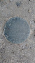
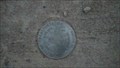
 view gallery view galleryN29.1 km | Z 79 Benchmark - Viroqua, WI in U.S. Benchmarks This disk was set in 1934 on top of the North end of a wing wall on the East side of County Hwy J. posted by: mrjcanger location: Wisconsin date approved: 09/29/2016 last visited: never |
 view gallery view galleryN29.5 km | VIROQUA S GPS Control Station - Viroqua, WI in U.S. Benchmarks Placed in 2004, this disk sits on the West side of County Hwy J. posted by: mrjcanger location: Wisconsin date approved: 09/29/2016 last visited: never |
 view gallery view galleryN30.7 km | Maple Dale Vertical Control - Viroqua, WI in U.S. Benchmarks Located on a bridge that spans the small creek from Maple Dale and 7 Reservoir, this disk is located on the Southwest wing wall. posted by: mrjcanger location: Wisconsin date approved: 10/20/2016 last visited: never |
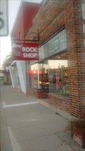 view gallery view galleryN31.5 km |  Gary's Rock Shop - Viroqua, WI, USA Gary's Rock Shop - Viroqua, WI, USA
in Mom and Pop Rock Shops In business for over 20 years, Gary's offers an amazing choice of rocks and fossils from around the world and locally. posted by: mrjcanger location: Wisconsin date approved: 11/14/2016 last visited: never |
|