 view gallery view gallery N16.1 km N16.1 km
|   Cows, Wildlife and Gold Cows, Wildlife and Gold
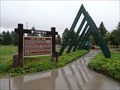
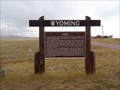
in Wyoming Historical Markers This Wyoming Historical Marker is one of two at the Mule Creek Junction Rest Area at Hwy 18 & 85 about 45 miles north of Lusk, Wyoming. posted by:  PeterNoG PeterNoG location: Wyoming date approved: 11/09/2016 last visited: 09/30/2016 |
 view gallery view galleryN16.1 km | Stewards of the Grassland Prairies in Wyoming Historical Markers This Wyoming Historical Marker is one of two at the Mule Creek Junction Rest Area at Hwy 18 & 85 about 45 miles north of Lusk, Wyoming. posted by: PeterNoG location: Wyoming date approved: 11/09/2016 last visited: 09/30/2016 |
 view gallery view galleryN16.1 km |  Highway 18 & 85 Rest Area, Mule Creek Junction, Wyoming Highway 18 & 85 Rest Area, Mule Creek Junction, Wyoming
in Blue Star Memorial Highway Markers The Blue Star Memorial Marker Program was adopted in 1945 by National Garden Clubs, Inc. (formerly National Council Of State Garden Clubs, Inc.), to honor the men and women of the Armed Forces of WWII. posted by: MNSearchers location: Wyoming date approved: 08/11/2006 last visited: 07/22/2007 |
 view gallery view gallery E20 km E20 km
|  Wyoming - South Dakota on Rt. 18 Wyoming - South Dakota on Rt. 18
in Border Crossings Open range area on the Great Plains. The southeast corner of this intersection is also a boundary in SD for the Buffalo Gap National Grassland. posted by:  Algoma! Algoma! location: South Dakota date approved: 06/04/2009 last visited: 09/30/2016 |
 view gallery view galleryE37.8 km |  Teddy Roosevelt's Visit to Edgemont Teddy Roosevelt's Visit to Edgemont
in South Dakota Historical Markers In 1903, Edgemont was host to President Teddy Roosevelt. An old friend from Deadwood, Seth Bullock, arrived with him to Edgemont. posted by: MNSearchers location: South Dakota date approved: 08/11/2006 last visited: 07/17/2007 |
 view gallery view galleryE38 km | Siding 7 in South Dakota Historical Markers In early 1890, the Burlington Railroad established Siding 7, three quarters ofa mile up the tracks north from Edgemont. posted by: MNSearchers location: South Dakota date approved: 08/11/2006 last visited: 07/17/2007 |
 view gallery view galleryE42.2 km | Camp Collier June 1876 ~ June 1877 in South Dakota Historical Markers Camp at the Mouth of Red Canyon, sometimes called Camp Collier , was established at this site in mid june 1876 to protect travelers over the 150 mile Cheyenne-Black Hills Stage Road. posted by: MNSearchers location: South Dakota date approved: 08/11/2006 last visited: 07/22/2007 |
 view gallery view gallery S54.9 km S54.9 km
|  CNW 10380 - Lusk, WY CNW 10380 - Lusk, WY
in Train Cabooses A CNW caboose on roadside display in a small Wyoming town. posted by: Telomere location: Wyoming date approved: 11/01/2016 last visited: never |
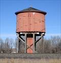 view gallery view galleryS54.9 km |  Lusk RR Water Tank, Lusk, WY Lusk RR Water Tank, Lusk, WY
in Water Towers Along side the railroad, an old tank made of redwood. posted by: ronjean location: Wyoming date approved: 11/27/2017 last visited: never |
 view gallery view galleryS55.7 km |  The Covered Wagon Motel -- Lusk WY The Covered Wagon Motel -- Lusk WY
in Covered Wagons Blasterz LOVE the Covered Wagon Motel in Lusk - we stay here everytime we are in the area. posted by: Benchmark Blasterz location: Wyoming date approved: 02/22/2013 last visited: 02/02/2013 |
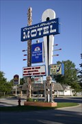 view gallery view galleryS55.7 km |  The Covered Wagon Motel -- Lusk WY The Covered Wagon Motel -- Lusk WY
in Recommended Accommodation The Covered Wagon is a historic motel now part of the America's Best Value Inn group. posted by: Benchmark Blasterz location: Wyoming date approved: 02/12/2013 last visited: 08/08/2009 |
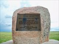 view gallery view galleryS55.7 km | Texas Trail Monument - Lusk, WY in Wyoming Historical Markers A simple monument describing the early cattle history of this part of Wyoming. posted by: cldisme location: Wyoming date approved: 07/14/2014 last visited: never |
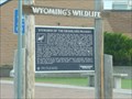
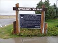 view gallery view galleryS57.3 km | Breaks in the Prairie - Lusk, WY in Wyoming Historical Markers A Wyoming's Wildlife marker at the rest area on the south side of US 18/20, a little over two miles southwest of Lusk, provides some background about the wildlife you'll see in the area. posted by: QuarrellaDeVil location: Wyoming date approved: 05/24/2020 last visited: 07/12/2024 |
 view gallery view galleryS57.3 km |  Breaks in the Prairie - Lusk, WY Breaks in the Prairie - Lusk, WY
in Flora and Fauna Information Signs A Wyoming's Wildlife sign at the rest area on the south side of US 18/20, a little over two miles southwest of Lusk, provides some background about the wildlife you'll see in the area. posted by: QuarrellaDeVil location: Wyoming date approved: 05/25/2020 last visited: 07/12/2024 |
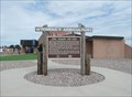
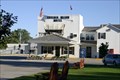
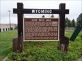 view gallery view galleryS57.3 km | Lusk Rest Area - Lusk, WY in Wyoming Historical Markers Wyoming Historical Marker at the rest area on the south side of US 18/20, a little over two miles southwest of Lusk, providing some history of this, Wyoming's first roadside beautification area, still blazing trails in the 21st century. posted by: QuarrellaDeVil location: Wyoming date approved: 05/22/2020 last visited: 07/12/2024 |
 view gallery view galleryS57.3 km |  Wyoming's FIRST Roadside Beautification Area - Lusk, WY Wyoming's FIRST Roadside Beautification Area - Lusk, WY
in First of its Kind A Wyoming Historical Marker at the rest area on the south side of US 18/20, a little over two miles southwest of Lusk, notes this as Wyoming's first roadside beautification area, still blazing trails in the 21st century. posted by: QuarrellaDeVil location: Wyoming date approved: 05/22/2020 last visited: 07/12/2024 |
 view gallery view galleryS57.3 km | Cheyenne-Deadwood Trail - Lusk, WY in Wyoming Historical Markers A historical marker at the rest area on the south side of US 18/20, a little over two miles southwest of Lusk, provides some history of the Cheyenne-Deadwood Trail, which passed right through where you're standing. posted by: QuarrellaDeVil location: Wyoming date approved: 05/24/2020 last visited: 07/12/2024 |
 view gallery view galleryE58.7 km |  Minnekahta Valley Cemetery, Hot Springs, South Dakota Minnekahta Valley Cemetery, Hot Springs, South Dakota
in Worldwide Cemeteries 35 graves in this small cemetery about a mile north of US Highway 18. posted by: NGComets location: South Dakota date approved: 12/10/2012 last visited: never |
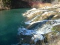 view gallery view galleryE59.1 km |  Cascade Falls Cascade Falls
in Waterfalls Cascade type falls with colorful blue/green waters and rocks that can crossed on foot just above the falls. posted by: plainsdrifter358 location: South Dakota date approved: 12/07/2006 last visited: 07/17/2007 |
 view gallery view galleryN60.7 km | Leaving South Dakota on HWY-16 in Border Crossings Its a barren HWY from Custer, SD to Moorcroft,WY posted by: BackPak location: Wyoming date approved: 10/20/2007 last visited: never |
 view gallery view galleryE61.3 km |  Cascade VFD Cascade VFD
in Firehouses Fire Department near Cascade, SD, now a ghost town. posted by: NGComets location: South Dakota date approved: 12/10/2012 last visited: never |
 view gallery view gallery W62 km W62 km
|  T40N R68W S28 S27 S34 S33 - Converse County, Wyoming T40N R68W S28 S27 S34 S33 - Converse County, Wyoming
in Public Land Survey Marks A section corner marker in the vicinity of Dull Center in northern Converse County. posted by: Tom.dog location: Wyoming date approved: 04/08/2024 last visited: never |
 view gallery view gallery SW63.6 km SW63.6 km
|  Jireh, WY Jireh, WY
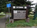
in Ghost Towns A Wyoming Historical Marker commemorates the now-vanished town of Jireh, as well as the college that was established there. Located on the south side of US 18/20, almost fifeen miles west of Lusk. posted by: QuarrellaDeVil location: Wyoming date approved: 10/12/2015 last visited: 05/03/2019 |
 view gallery view gallerySW63.6 km | Jireh in Wyoming Historical Markers Wyoming Historical Marker noting the establishment of the Jireh settlement, which grew into a college and a town. Located on the south side of US 18/20, almost fifteen miles west of Lusk. posted by: QuarrellaDeVil location: Wyoming date approved: 09/30/2015 last visited: 05/03/2019 |
 view gallery view gallery NE65 km NE65 km
|  Jewel Cave National Monument - Custer, South Dakota, USA Jewel Cave National Monument - Custer, South Dakota, USA
in National Parks of the World This cave was thought to a be a small yet exquisite cave in 1908 when it was made a National Monument. Now 137 miles have been explored and it may possibly be the longest continuous cave in the world. posted by: Hikenutty location: South Dakota date approved: 07/16/2007 last visited: 07/30/2023 |
|