 view gallery view gallery NE36.7 km NE36.7 km
|   J 57 (OU0221) - Converse County, Wyoming J 57 (OU0221) - Converse County, Wyoming
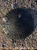
in U.S. Benchmarks A benchmark on the north side of USFS Road 961 a short distance west of WY State Highway 59. posted by:  Tom.dog Tom.dog location: Wyoming date approved: 10/21/2022 last visited: never |
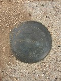
 view gallery view galleryNE38.1 km | BILL NO 2 - Converse County, Wyoming in U.S. Benchmarks Reference mark 2 for USGS benchmark BILL (OU0415). posted by: Tom.dog location: Wyoming date approved: 01/08/2023 last visited: never |
 view gallery view galleryNE38.1 km | BILL NO 1 - Converse County, Wyoming in U.S. Benchmarks Reference mark 1 for USGS benchmark BILL (OU0415). posted by: Tom.dog location: Wyoming date approved: 01/08/2023 last visited: never |
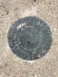
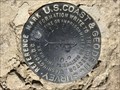
 view gallery view galleryNE38.1 km | BILL (OU0415) - Converse County, Wyoming in U.S. Benchmarks This USGS benchmark is located at the top of a rise adjacent to State Highway 59, about 2.9 miles to the northwest of the beautiful "blink-and-you'll-miss-it" town of Bill, Wyoming. posted by: Tom.dog location: Wyoming date approved: 01/08/2023 last visited: never |
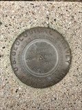
 view gallery view gallery SE43.9 km SE43.9 km
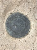
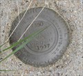
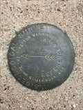
| SW 50 in U.S. Benchmarks USGS SW 50 set in concrete block posted by: corankinrok location: Wyoming date approved: 05/09/2009 last visited: never |
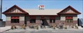 view gallery view gallerySE47.5 km |  Chicago, Burlington & Quincy Depot -- Douglas WY Chicago, Burlington & Quincy Depot -- Douglas WY
in Train Stations/Depots The old Chicago, Burlington, & Quincy depot in Douglas is now a restaurant called, surprisingly, The Depot. posted by: Benchmark Blasterz location: Wyoming date approved: 02/03/2014 last visited: 08/07/2013 |
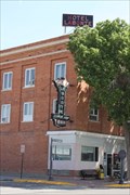 view gallery view gallerySE47.5 km |  Hotel Labonte -- Douglas WY Hotel Labonte -- Douglas WY
in U.S. National Register of Historic Places The Hotel Labonte in downtown Douglas WY is on the National Register of Historic Places. posted by: Benchmark Blasterz location: Wyoming date approved: 02/01/2014 last visited: 08/07/2013 |
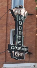 view gallery view gallerySE47.5 km |  Hotel Labonte -- Douglas WY Hotel Labonte -- Douglas WY
in Neon Signs The Hotel Labonte is a fixture in downtown Douglas. Its unique neon sign and high roof sign can be seen for miles across the prairie, beckoning travelers by rail, and by road. posted by: Benchmark Blasterz location: Wyoming date approved: 02/03/2014 last visited: 08/07/2013 |
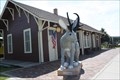
 view gallery view gallerySE47.6 km |  Douglas Railroad Interpretive Center -- Douglas WY Douglas Railroad Interpretive Center -- Douglas WY
in Railroad Museums A historic 1886 depot is now home to a very nice display of vintage local railroad equipment. posted by: Benchmark Blasterz location: Wyoming date approved: 02/03/2014 last visited: 05/26/2023 |
 view gallery view gallerySE47.6 km | Fremont, Elkhorn & Missouri Valley Railroad Passenger Depot -- Douglas WY in U.S. National Register of Historic Places The wood-frame former Fremont, Elkhorn & Missouri Valley Railroad Passenger Depot (also known as the Chicago & Northwestern RR Depot) is on the National Register of Historic Places. posted by: Benchmark Blasterz location: Wyoming date approved: 02/01/2014 last visited: 08/07/2013 |
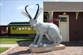
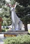 view gallery view gallerySE47.8 km |  Jackalope -- Douglas WY Jackalope -- Douglas WY
in Epic Beings and Creatures This 9 foot jackalope at the US 26 and 4th Street is one of many in the town of Douglas WY -- can you spot them all? posted by: Benchmark Blasterz location: Wyoming date approved: 02/02/2014 last visited: 08/07/2013 |
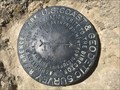
 view gallery view gallerySE48.1 km | SYBRANT NO 1 - Converse County, Wyoming in U.S. Benchmarks Reference mark 1 for USGS benchmark SYBRANT (NQ0535). posted by: Tom.dog location: Wyoming date approved: 01/07/2023 last visited: never |
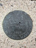
 view gallery view gallerySE48.1 km | SYBRANT (NQ0535) - Converse County, Wyoming in U.S. Benchmarks A USGS benchmark on top of a hill to the north of Douglas, Wyoming. posted by: Tom.dog location: Wyoming date approved: 01/07/2023 last visited: never |
 view gallery view gallerySE48.1 km | SYBRANT NO 2 - Converse County, Wyoming in U.S. Benchmarks Reference mark 2 for USGS benchmark SYBRANT (NQ0535). posted by: Tom.dog location: Wyoming date approved: 01/07/2023 last visited: never |
 view gallery view gallery NW49.1 km NW49.1 km
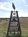
|  Scandal!: Tempest at the Teapot - Teapot Dome, Wyoming Scandal!: Tempest at the Teapot - Teapot Dome, Wyoming
in Wyoming Historical Markers One of two historical markers at a pull-off along State Highway 259 that present history about the Salt Creek Oilfield, which was the site of a major U.S. oil scandal. posted by: Tom.dog location: Wyoming date approved: 08/27/2023 last visited: never |
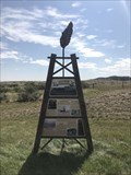 view gallery view galleryNW49.1 km | Salt Creek: Producing Oil for over a Century - Teapot Dome, Wyoming in Wyoming Historical Markers One of two historical markers at a pull-off along State Highway 259 that present history about the Salt Creek Oilfield, which was the site of Wyoming's first oil boom. posted by: Tom.dog location: Wyoming date approved: 08/27/2023 last visited: never |
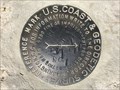
 view gallery view galleryNW51.5 km | MIDWEST AZI - Natrona County, Wyoming in U.S. Benchmarks This is the precariously-placed azimuth mark for triangulation station MIDWEST. posted by: Tom.dog location: Wyoming date approved: 05/08/2023 last visited: never |
 view gallery view galleryNW51.5 km |  MIDWEST AZI - Natrona County, Wyoming MIDWEST AZI - Natrona County, Wyoming
in Azimuth Benchmarks The cliff-edge azimuth mark for triangulation station MIDWEST (OV0346). posted by: Tom.dog location: Wyoming date approved: 07/05/2023 last visited: never |
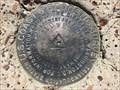 view gallery view galleryNW51.7 km | MIDWEST (OV0346) - Natrona County, Wyoming in U.S. Benchmarks Triangulation station MIDWEST is located at the top of a large butte to the south of the historic oil boom towns of Midwest and Edgerton. posted by: Tom.dog location: Wyoming date approved: 05/08/2023 last visited: never |
 view gallery view galleryNW51.7 km | MIDWEST NO 1 - Natrona County, Wyoming in U.S. Benchmarks Reference mark 1 for triangulation station MIDWEST. posted by: Tom.dog location: Wyoming date approved: 05/08/2023 last visited: never |
 view gallery view galleryNW51.7 km | MIDWEST NO 2 - Natrona County, Wyoming in U.S. Benchmarks Reference mark 2 for triangulation station MIDWEST. posted by: Tom.dog location: Wyoming date approved: 05/08/2023 last visited: never |
 view gallery view gallery N52.5 km N52.5 km
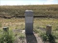
| Bozeman Trail - Campbell County, Wyoming in Wyoming Historical Markers A marker from 1914 that indicates where the historic Bozeman Trail would have crossed the modern State Highway 387. posted by: Tom.dog location: Wyoming date approved: 08/27/2023 last visited: never |
 view gallery view galleryN52.5 km |  Bozeman Trail Marker - Campbell County, Wyoming Bozeman Trail Marker - Campbell County, Wyoming
in Wagon Roads and Trails This 1914 Wyoming historical marker denotes where the Bozeman Trail, marked by John Bozeman and John Jacobs in the early 1860s, crosses State Highway 387. posted by: Tom.dog location: Wyoming date approved: 09/03/2023 last visited: never |
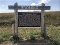
 view gallery view galleryN52.5 km | Bozeman Trail Historical Sign - Campbell County, Wyoming in Wagon Roads and Trails This sign, which gives a short history of the Bozeman Trail, has been erected where the trail would have crossed State Highway 387. posted by: Tom.dog location: Wyoming date approved: 09/03/2023 last visited: never |
 view gallery view galleryN52.5 km | The Bozeman Trail - Campbell County, Wyoming in Wyoming Historical Markers A historical marker on the side of State Highway 387 where the Bozeman Trail once crossed. posted by: Tom.dog location: Wyoming date approved: 08/27/2023 last visited: never |
|