 view gallery view gallery S3.9 km S3.9 km
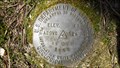
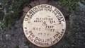
|   25 DVH 1980 (USDI, Hancock, NH) 25 DVH 1980 (USDI, Hancock, NH)
in U.S. Benchmarks A USDI standard disk, located in Hancock, NH.
The NHDOT ID# is 201-0150. posted by:  NH2beers NH2beers location: New Hampshire date approved: 04/09/2012 last visited: never |
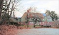 view gallery view galleryS5 km |  Harris Center for Conservation & Education - Hancock, NH Harris Center for Conservation & Education - Hancock, NH
in Nature Centers As a land trust, the Harris Center conserves over 8800 acres in the Monadnock Region of southern New Hampshire. With a large interpretive center with displays and meeting rooms, an extensive trail system, they conduct educational and school programs posted by: silverquill location: New Hampshire date approved: 06/26/2007 last visited: never |
 view gallery view galleryS5 km |  Bobcat Weathervane on Harris Center - Hancock, NH Bobcat Weathervane on Harris Center - Hancock, NH
in Unique Weathervanes This weather vane depicting a bobcat is on the Harris Nature Center near the rural community of Hancock, New Hampshire. posted by: silverquill location: New Hampshire date approved: 10/10/2007 last visited: never |
 view gallery view galleryS5 km |  Harris Center for Conservation & Education - Hancock, NH Harris Center for Conservation & Education - Hancock, NH
in Octagon Buildings This octagonal building is part of the visitors center and educational complex at the Harris Center for Conservation & Education in Hancock, New Hampshire. They a land trust for over 8,800 acres and conduct many educational programs in this building posted by: silverquill location: New Hampshire date approved: 06/24/2007 last visited: never |
 view gallery view gallery NW5.1 km NW5.1 km
|  Stoddard Glass Stoddard Glass
in New Hampshire Historical Markers A sign marking New Hampshire glassworks in the mid to late 1800's. posted by:  New England n00b New England n00b location: New Hampshire date approved: 09/04/2006 last visited: 09/25/2005 |
 view gallery view gallery N5.8 km N5.8 km
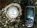
| 425 0150 in U.S. Benchmarks A New Hampshire Department of Transporation survey marker located near a historic double stone arch bridge near the Stoddard/Antrim town line on NH Route 9. posted by: Jay-7 location: New Hampshire date approved: 06/24/2012 last visited: 11/13/2013 |
 view gallery view galleryN6 km |  Stone Arch Bridge - Stoddard, NH Stone Arch Bridge - Stoddard, NH
in Orphaned Bridges Bridge now fenced off, and you cannot walk on it, nor is it used for the 19th Century road for which it was built. posted by: YoSam. location: New Hampshire date approved: 01/02/2014 last visited: never |
 view gallery view galleryN6 km |  Stone Arch Bridge - Stoddard, NH Stone Arch Bridge - Stoddard, NH
in Arch Bridges Bridge was fenced off when I visited, but photos now show you can walk across it to view site. posted by: YoSam. location: New Hampshire date approved: 01/01/2014 last visited: never |
 view gallery view galleryN6 km |  Stone Arch Bridge, Cheshire County, New Hampshire Stone Arch Bridge, Cheshire County, New Hampshire
in Stone Bridges Twin arch structure built without mortar. posted by: YoSam. location: New Hampshire date approved: 07/03/2008 last visited: never |
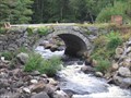 view gallery view galleryN6 km | Stone Arch Bridge in New Hampshire Historical Markers A marker noting early nineteenth century bridgework. posted by: New England n00b location: New Hampshire date approved: 09/04/2006 last visited: 09/25/2005 |
 view gallery view gallery SE6 km SE6 km
|  Seven Maples Campground (Hancock, NH) Seven Maples Campground (Hancock, NH)
in Campgrounds A privately owned campground, located in Hancock, New Hampshire. posted by: NH2beers location: New Hampshire date approved: 07/13/2011 last visited: never |
 view gallery view gallerySE6.1 km |  Hancock Town Library - Hancock, NH Hancock Town Library - Hancock, NH
in Libraries A trip around the Hancock town green is a journey into Colonial history! This small library is a primary resource for historical research in the town of Hancock, New Hampshire. posted by: silverquill location: New Hampshire date approved: 05/07/2007 last visited: never |
 view gallery view gallerySE6.1 km | MAC 37 1925 (USGS, Hancock, NH) in U.S. Benchmarks A USGS standard bench mark disk, located at the Hancock train depot, in Hancock, NH.
The NHDOT ID# is 201-0030. posted by: NH2beers location: New Hampshire date approved: 07/06/2011 last visited: never |
 view gallery view gallerySE6.1 km |  Hancock Train Station (Hancock, NH) Hancock Train Station (Hancock, NH)
in Train Stations/Depots This is the former train station/depot, located in Hancock, NH. posted by: NH2beers location: New Hampshire date approved: 07/13/2011 last visited: never |
 view gallery view gallerySE6.1 km | MY2227: B 12 1935 (USC&GS/NGS, Hancock, NH) in U.S. Benchmarks A USC&GS standard bench mark disk, located in Hancock, NH.
The NGS PID# is MY2227.
The NHDOT ID# is 201-0100. posted by: NH2beers location: New Hampshire date approved: 07/14/2011 last visited: never |
 view gallery view gallerySE6.6 km |  Norway Pond Beach - Hancock, NH Norway Pond Beach - Hancock, NH
in Municipal Parks and Plazas This beach area and hiking trails at Norway Pond are maintained by the historic village of Hancock, New Hampshire. posted by: silverquill location: New Hampshire date approved: 03/22/2008 last visited: never |
 view gallery view gallerySE6.6 km |  Hancock, NH 03449 Hancock, NH 03449
in U.S. Post Offices This traditional New England white frame building is home to the post office in the old historic town of Hancock, New Hampshire. posted by: silverquill location: New Hampshire date approved: 12/31/2007 last visited: never |
 view gallery view gallerySE6.6 km |  Congregational Church Clock - Hancock, NH Congregational Church Clock - Hancock, NH
in Town Clocks This clock is mounted in the steeple of the First Congregational Church in historic Hancock, New Hampshire. posted by: silverquill location: New Hampshire date approved: 02/26/2008 last visited: never |
 view gallery view gallerySE6.8 km |  Hancock, NH Hancock, NH
in City and Town Halls This is the city hall for the historic village of Hancock, New Hampshire. posted by: silverquill location: New Hampshire date approved: 02/27/2008 last visited: never |
 view gallery view gallerySE6.9 km |  Charles Symonds House - Hancock Village Historic District - Hancock NH Charles Symonds House - Hancock Village Historic District - Hancock NH
in NRHP Historic Districts - Contributing Buildings Historic home built in 1808/09. posted by: nomadwillie location: New Hampshire date approved: 12/15/2013 last visited: never |
 view gallery view gallerySE6.9 km |  Hancock Historical Society - Hancock NH Hancock Historical Society - Hancock NH
in Historical Society Headquarters Historic home built in 1808/09. posted by: nomadwillie location: New Hampshire date approved: 12/19/2013 last visited: never |
 view gallery view galleryS6.9 km | MZ0007: C 12 1935 (USC&GS/NGS, Hancock, NH) in U.S. Benchmarks A USG&GS standard bench mark disk, located in Hancock, NH.
The NGS PID# is MZ0007.
The NHDOT ID# is 201-0010. posted by: NH2beers location: New Hampshire date approved: 04/09/2012 last visited: never |
 view gallery view gallerySE7.6 km | MY2226: A 12 1935 (USC&GS/NGS, Hancock, NH) in U.S. Benchmarks A USC&GS standard bench mark disk, located in Hancock, NH.
The NGS PID# is MY2226.
The NHDOT ID# is 201-0090. posted by: NH2beers location: New Hampshire date approved: 07/11/2011 last visited: never |
 view gallery view gallery E7.6 km E7.6 km
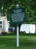
| New Hampshire's Last Soldier of the Revolution in New Hampshire Historical Markers This marker is located in Antrim on US 202 right neat the intersection with NH 31 posted by: nomadwillie location: New Hampshire date approved: 09/22/2009 last visited: 10/26/2009 |
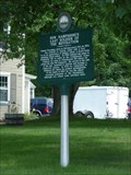 view gallery view galleryE7.6 km |  New Hampshire's Last Soldier of the Revolution New Hampshire's Last Soldier of the Revolution
in Last of its Kind This marker is located in Antrim on US 202 right neat the intersection with NH 31.
posted by: nomadwillie location: New Hampshire date approved: 10/26/2009 last visited: 10/26/2009 |
|