 view gallery view gallery E4.7 km E4.7 km
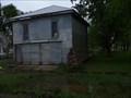
|   Abandoned Fire Station, Utica, South Dakota, USA Abandoned Fire Station, Utica, South Dakota, USA
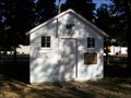
in Unoccupied Buildings, Shacks, and Cabins A new fire station was built several years ago, and this one abandoned.
Elevation 1373 posted by:  NGComets NGComets location: South Dakota date approved: 06/04/2019 last visited: never |
 view gallery view galleryE4.7 km |  Utica Public School, Utica, South Dakota Utica Public School, Utica, South Dakota
in Former Schools Elevation 1872 posted by: NGComets location: South Dakota date approved: 06/15/2019 last visited: never |
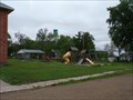 view gallery view galleryE4.7 km |  Utica City Park, Utica, South Dakota Utica City Park, Utica, South Dakota
in Public Playgrounds Nice little park in a very small town. Elevation 1872 posted by: NGComets location: South Dakota date approved: 06/03/2019 last visited: never |
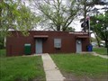 view gallery view galleryE4.7 km |  Utica, South Dakota 57067 Utica, South Dakota 57067
in U.S. Post Offices Small town post office. Elevation 1383 posted by: NGComets location: South Dakota date approved: 06/15/2019 last visited: never |
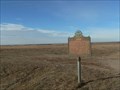
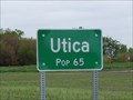 view gallery view galleryE5.1 km |  Utica, South Dakota - Population 65 Utica, South Dakota - Population 65
in Population Signs Very small town northwest of Yankton, SD. Elevation 1383 posted by: NGComets location: South Dakota date approved: 06/02/2019 last visited: never |
 view gallery view gallery NW7.4 km NW7.4 km
| Lesterville, South Dakota 57040 in U.S. Post Offices Small town post office.
Elevation 1390 posted by: NGComets location: South Dakota date approved: 12/11/2017 last visited: never |
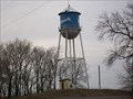 view gallery view galleryNW7.7 km |  Watertower, Lesterville, South Dakota Watertower, Lesterville, South Dakota
in Water Towers Small town watertower. Elevation 1405. posted by: NGComets location: South Dakota date approved: 12/06/2017 last visited: never |
 view gallery view gallery W9 km W9 km
|  "American Legion Post 183", Tabor, South Dakota "American Legion Post 183", Tabor, South Dakota
in Legion Posts and Branches Small post in a small town. posted by: NGComets location: South Dakota date approved: 03/26/2013 last visited: never |
 view gallery view galleryW9 km |  Tabor Jail, Tabor, South Dakota Tabor Jail, Tabor, South Dakota
in Retired Prisons Donated by Mary and Emil Dvoracek in memory of the John Dvoracek family. posted by: NGComets location: South Dakota date approved: 10/19/2012 last visited: never |
 view gallery view galleryW9 km | Tabor, South Dakota 57063 in U.S. Post Offices Small town post office. posted by: NGComets location: South Dakota date approved: 10/12/2012 last visited: never |
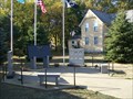 view gallery view galleryW9 km |  Tabor Memorial Tabor Memorial
in Non-Specific Veteran Memorials Nice memorial in a small town. posted by: NGComets location: South Dakota date approved: 10/22/2012 last visited: never |
 view gallery view gallery SW10.8 km SW10.8 km
|  FIRST -- School & Schoolteacher, Tabor SD USA FIRST -- School & Schoolteacher, Tabor SD USA
in First of its Kind A litany of firsts from 1872-1876 are listed on this historical marker on the South Dakota State Highway 50 south of the small SD Czech community of Tabor posted by: Benchmark Blasterz location: South Dakota date approved: 02/15/2023 last visited: 02/16/2023 |
 view gallery view gallerySW10.8 km | FIRST -- Priest & Catholic Church, Tabor SD USA in First of its Kind A litany of firsts from 1872-1876 are listed on this historical marker on the South Dakota State Highway 50 south of the small SD Czech community of Tabor posted by: Benchmark Blasterz location: South Dakota date approved: 02/15/2023 last visited: 02/16/2023 |
 view gallery view gallerySW10.8 km | FIRST -- Postmaster, Tabor SD USA in First of its Kind A litany of firsts from 1872-1876 are listed on this historical marker on the South Dakota State Highway 50 south of the small SD Czech community of Tabor posted by: Benchmark Blasterz location: South Dakota date approved: 02/15/2023 last visited: 02/16/2023 |
 view gallery view gallerySW10.8 km | FIRST -- Storekeeper, Tabor SD USA in First of its Kind A litany of firsts from 1872-1876 are listed on this historical marker on the South Dakota State Highway 50 south of the small SD Czech community of Tabor posted by: Benchmark Blasterz location: South Dakota date approved: 02/15/2023 last visited: 02/16/2023 |
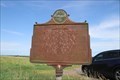
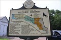
 view gallery view gallerySW10.8 km |  Tabor and Missouri River Historic Highway -- SD SH 50 south of Tabor SD Tabor and Missouri River Historic Highway -- SD SH 50 south of Tabor SD
in South Dakota Historical Markers Tabor is 'The Mother City of Dakota Czechs.' On obverse side of the marker is a map of historic places along the Missouri River Highway. posted by: plainsdrifter358 location: South Dakota date approved: 01/02/2007 last visited: 02/15/2023 |
 view gallery view gallerySW10.8 km | FIRST -- Town officers of Tabor, Tabor SD USA in First of its Kind A litany of firsts from 1872-1876 are listed on this historical marker on the South Dakota State Highway 50 south of the small SD Czech community of Tabor posted by: Benchmark Blasterz location: South Dakota date approved: 02/15/2023 last visited: 02/16/2023 |
 view gallery view gallery SE15.3 km SE15.3 km
|  Gavins Point Dam - Yankton, SD - USA Gavins Point Dam - Yankton, SD - USA
in Hydroelectric Power Stations Gavins Point Dam is a hydroelectric dam on the Missouri River on the border between Nebraska and South Dakota. Built from 1952 to 1957, it retains Lewis and Clark Lake. posted by: beta59 location: South Dakota date approved: 10/16/2012 last visited: 08/10/2014 |
 view gallery view gallerySE15.8 km |  Yankton Municipal Cemetery, Yankton, South Dakota Yankton Municipal Cemetery, Yankton, South Dakota
in Worldwide Cemeteries First city cemetery in the Dakota Territory. The Sacred Heart Catholic Cemetery is adjacent to this one. posted by: NGComets location: South Dakota date approved: 06/04/2019 last visited: never |
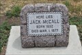 view gallery view gallerySE15.8 km |  "Broken Nose" Jack McCall - Yankton, SD "Broken Nose" Jack McCall - Yankton, SD
in Grave of a Famous Person "Broken Nose" Jack McCall is a western folk figure that is best known as the man who shot Wild Bill Hickok on April 2, 1876 in Deadwood, South Dakota. posted by: Sneakin Deacon location: South Dakota date approved: 03/11/2023 last visited: never |
 view gallery view gallerySE15.9 km |  Lewis & Clark Visitor Center - Gavins Point Dam, NE Lewis & Clark Visitor Center - Gavins Point Dam, NE
in NPS Passport Cancellation Stations The Lewis & Clark Center at Gavins Point Dam is administered by the NPS and has 2 cancellations, Missouri NRR and Lewis & Clark Heritage Trail. posted by: The WBs location: Nebraska date approved: 07/22/2014 last visited: 07/16/2014 |
 view gallery view gallerySE15.9 km |  John S. Lann AKA John S. Lanning-Yankton, SD John S. Lann AKA John S. Lanning-Yankton, SD
in Medal Of Honor Resting Places Civil War Medal of Honor Recipient for action on board the USS Magnolia at St. Marks, FL on March 5-6, 1862. He served in the military under an alias, John S. Lann. His true name was John S. Lanning. He is buried in Yankton City Cemetery, Yankton, SD in Block 352, Lot 1. posted by:  Don.Morfe Don.Morfe location: South Dakota date approved: 11/02/2018 last visited: 12/07/2021 |
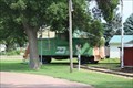 view gallery view gallerySE16.7 km |  BN 10014 -- Dakota Territorial Museum, Yankton SD USA BN 10014 -- Dakota Territorial Museum, Yankton SD USA
in Train Cabooses BN caboose number 10014 on public display at Dakota Territorial Museum, Yankton SD USA posted by: Benchmark Blasterz location: South Dakota date approved: 02/18/2023 last visited: 02/18/2023 |
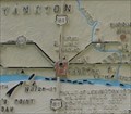 view gallery view gallerySE16.7 km |  You are Here -- Yankton SD USA You are Here -- Yankton SD USA
in 'You Are Here' Maps This "You are Here" map is located on the back of a historical marker at the Dakota Territorial Museum posted by: Benchmark Blasterz location: South Dakota date approved: 02/17/2023 last visited: 03/03/2023 |
 view gallery view gallerySE16.7 km |  Yankton: Mother City of the Dakotas -- Dakota Territorial Museum, Westside Park, Yankton SD USA Yankton: Mother City of the Dakotas -- Dakota Territorial Museum, Westside Park, Yankton SD USA
in Lewis and Clark Trail State historical marker for Yankton: Mother City of the Dakotas has a map of the Lewis and Clark campsites across 3 counties, and shows where they had a council with local Sioux Indians at the modern site of the Gavins Point Dam posted by: Benchmark Blasterz location: South Dakota date approved: 02/16/2023 last visited: 02/17/2023 |
|