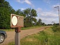
 view gallery view gallery SE2.7 km SE2.7 km
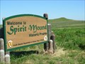
|   SPIRIT MOUND A NATIONAL HISTORIC SITE Vermillion, South Dakota SPIRIT MOUND A NATIONAL HISTORIC SITE Vermillion, South Dakota
in Lewis and Clark Trail On August 25, 1804, Lewis and Clark walked to this conical hill which the Indians believed to be the residence of "little people or Spirits." posted by:  RB2 RB2 location: South Dakota date approved: 06/27/2007 last visited: 07/30/2013 |
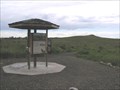 view gallery view gallerySE2.9 km |  Spirit Mound Spirit Mound
in U.S. National Register of Historic Places Spirit Mound is located approximately six miles north of Vermillion, South Dakota on Hwy. 19. A state park, Spirit Mound Historic Prairie, was recently established, and the landscape is being restored. An interpretive sign is located at the I-29 Information Center near Junction City, and a small parking lot and day use area will be established by 2004 at the NW corner of the intersection of State Hwy. 19 and 312th St. For more information, visit the Spirit Mound Historic Prairie website or call posted by:  MNSearchers MNSearchers location: South Dakota date approved: 06/27/2006 last visited: 07/30/2013 |
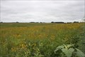 view gallery view gallerySE2.9 km |  Spirit Mound -- nr Vermillion SD Spirit Mound -- nr Vermillion SD
in Flower Fields The beautiful and mystical Spirit Mound prairie has been restored and preserved. Many kinds of flowers, grasses, and vines grow here. posted by: Benchmark Blasterz location: South Dakota date approved: 12/18/2013 last visited: 07/31/2013 |
 view gallery view gallery NE9.3 km NE9.3 km
|  Ball Field, Hub City, South Dakota Ball Field, Hub City, South Dakota
in Amateur Baseball Fields Ben Carlson Memorial Field. Not so used anymore. posted by: NGComets location: South Dakota date approved: 05/12/2010 last visited: never |
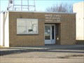
 view gallery view galleryNE9.3 km |  Hub City Hub City
in South Dakota Historical Markers On a midsummer's day on June 24, 1925 Wm. Inberg & Arvid Johnson opened the newly built gas station & repair business Hub City garage. posted by: GPX Navigators location: South Dakota date approved: 05/14/2006 last visited: 05/08/2010 |
 view gallery view galleryNE11.4 km | Dalesburg School - Dalesburg Village in South Dakota Historical Markers Name of Dalesburg, was suggested for this community of Swedish immigrants in 1869 when attempts were made to organize a church.
Dalesburg School was located one-half mile south of the village on land donated by the Bergs in 1872. posted by: GPX Navigators location: South Dakota date approved: 05/14/2006 last visited: 06/18/2006 |
 view gallery view gallery S11.7 km S11.7 km
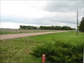
| The Missouri River Historic Highway & Vermillion in South Dakota Historical Markers Vermillion early history and description of the Missouri River historic highway. posted by: plainsdrifter358 location: South Dakota date approved: 05/24/2006 last visited: 08/08/2007 |
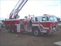 view gallery view galleryS11.9 km |  Vermillion, SD Vermillion, SD
in Fire Fighting Vehicles A few trucks from the Vermillion, SD volunteer fire department. posted by: TheNinnymuggins location: South Dakota date approved: 11/13/2005 last visited: 03/26/2011 |
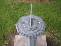 view gallery view galleryS12.4 km |  University of South Dakota Sun Dial University of South Dakota Sun Dial
in Sundials Sundial located on the grounds of University of South Dakota in Vermillion SD. posted by: MNSearchers location: South Dakota date approved: 07/12/2006 last visited: 03/26/2011 |
 view gallery view galleryS12.4 km |  National Music Museum - Vermillion, SD National Music Museum - Vermillion, SD
in History Museums The National Music Museum is a one of a kind museum with displays of all types of musical instruments from all cultures and covering the history of instruments. posted by: beta59 location: South Dakota date approved: 03/27/2011 last visited: 12/28/2011 |
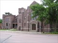 view gallery view galleryS12.7 km | The First Baptist Church in U.S. National Register of Historic Places First Baptist Church in Vermillion South Dakota. posted by: MNSearchers location: South Dakota date approved: 06/23/2006 last visited: 12/28/2011 |
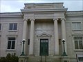
 view gallery view galleryS12.7 km | Carnegie Library in U.S. National Register of Historic Places Carnegie Library now used as a Law Office. posted by: MNSearchers location: South Dakota date approved: 06/24/2006 last visited: 03/26/2011 |
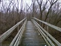 view gallery view galleryS13.4 km |  Cotton Park Suspension Bridge - Vermillion, SD Cotton Park Suspension Bridge - Vermillion, SD
in Pedestrian Suspension Bridges A suspension bridge in Cotton Park that brings the pedestrian to an island in the middle of the Vermillion River. posted by: beta59 location: South Dakota date approved: 03/28/2011 last visited: 02/18/2012 |
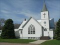 view gallery view gallery SW14.3 km SW14.3 km
|  Bergen Lutheran - SD Bergen Lutheran - SD
in Country Churches Historic and well-maintained rural church near the Missouri River. posted by: plainsdrifter358 location: South Dakota date approved: 05/12/2008 last visited: 04/23/2008 |
 view gallery view gallery W15 km W15 km
| Post Vermillion or Dicksons Post <----6 miles south### in South Dakota Historical Markers In 1822 the Columbis Fur Company established a post at Audubons Point. posted by: MNSearchers location: South Dakota date approved: 07/10/2006 last visited: 11/19/2006 |
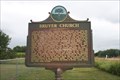 view gallery view gallerySE15.3 km | Bruyer Church -- nr Vermillion SD in South Dakota Historical Markers This roadside marker is located at a small cemetery a few miles east of Vermillion SD on the SD state highway 50 posted by: Benchmark Blasterz location: South Dakota date approved: 01/23/2014 last visited: 08/02/2013 |
 view gallery view galleryW15.8 km |  Gayville, South Dakota 57031 Gayville, South Dakota 57031
in U.S. Post Offices Small town post office. posted by: NGComets location: South Dakota date approved: 01/06/2013 last visited: never |
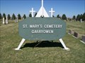 view gallery view gallery E15.9 km E15.9 km
|  St. Mary Cemetery; Garryowen, South Dakota St. Mary Cemetery; Garryowen, South Dakota
in Worldwide Cemeteries Located near the former town of Garryowen, South Dakota. Elevation 1230.
300 graves posted by: NGComets location: South Dakota date approved: 04/20/2015 last visited: never |
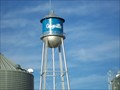 view gallery view galleryW15.9 km |  Watertower, Gayville, South Dakota Watertower, Gayville, South Dakota
in Water Towers Small town watertower. posted by: NGComets location: South Dakota date approved: 01/01/2013 last visited: never |
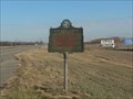 view gallery view gallerySE16.7 km | First Rural Electric Cooperative in South Dakota Historical Markers Site of the first rural electric cooperative in South Dakota. posted by: plainsdrifter358 location: South Dakota date approved: 11/26/2006 last visited: 08/07/2007 |
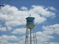 view gallery view gallery NW16.9 km NW16.9 km
| Watertower, Wakonda, South Dakota in Water Towers Watertower in a small town. posted by: NGComets location: South Dakota date approved: 05/11/2010 last visited: never |
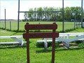
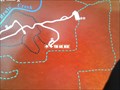 view gallery view galleryE16.9 km |  Union Grove Trail System - Beresford, SD Union Grove Trail System - Beresford, SD
in 'You Are Here' Maps This is a trail head at a place in the park called Parkview Hill which is also the highest point in eastern South Dakota. posted by: beta59 location: South Dakota date approved: 04/22/2012 last visited: 04/21/2012 |
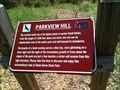 view gallery view galleryE17.1 km |  HIGHEST - Point in Eastern South Dakota - Parkview Hill HIGHEST - Point in Eastern South Dakota - Parkview Hill
in Superlatives Parkview Hill in Union Grove State park south of Beresford, SD is the highest point in Eastern South Dakota. posted by: beta59 location: South Dakota date approved: 04/22/2012 last visited: never |
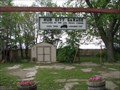
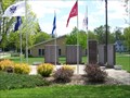 view gallery view galleryNW17.1 km |  Waconda Veterans Memorial Waconda Veterans Memorial
in Non-Specific Veteran Memorials Located in Waconda, SD. posted by: NGComets location: South Dakota date approved: 05/26/2010 last visited: 08/02/2010 |
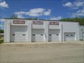 view gallery view galleryNW17.1 km | Waconda Community Fire Dept. in Firehouses Located in Waconda, South Dakota posted by: NGComets location: South Dakota date approved: 05/15/2010 last visited: never |
|