 view gallery view gallery NW0.3 km NW0.3 km
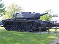
|   M60A2 - Armada Michigan M60A2 - Armada Michigan
in Military Ground Equipment Displays M60A2 Heavy Tank on static display at the north end of Armada, MI.,at AMVETS Post 93. posted by:  Leader1 Leader1 location: Michigan date approved: 06/14/2010 last visited: 10/28/2014 |
 view gallery view gallery S1 km S1 km
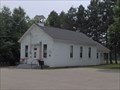
|  Armada Free Public Library; Armada, Michigan Armada Free Public Library; Armada, Michigan
in Carnegie Library Buildings The small town of Armada, Michigan has supported a public library for over a century. posted by: boatchick location: Michigan date approved: 12/30/2009 last visited: 12/07/2013 |
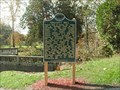
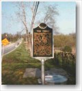
 view gallery view galleryS9.8 km |  Ray Township District No. 1 School Ray Township District No. 1 School
in Michigan Historical Markers This is a two-sided marker with two UNIQUE site numbers and two waymarks. The school is the north facing side of the marker. Located on the west side of Wolcott Road just north of the intersection with Indian Trail. Plenty of parking available. posted by: S5280ft location: Michigan date approved: 07/03/2006 last visited: 01/06/2014 |
 view gallery view galleryS9.8 km | Religious Society Church in Michigan Historical Markers This is a two-sided marker with two UNIQUE site numbers and two waymarks. The church is the south facing side of the marker. Located on the west side of Wolcott Road just north of the intersection with Indian Trail. Plenty of parking available. posted by: S5280ft location: Michigan date approved: 05/01/2007 last visited: 01/06/2014 |
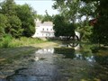
 view gallery view galleryS10 km | Wolcott Mill in Michigan Historical Markers Wolcott Mill is a part of the Metropark system and a park pass is necessary. posted by: Rattrak location: Michigan date approved: 10/31/2013 last visited: 05/28/2018 |
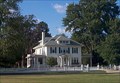
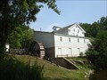 view gallery view galleryS10.1 km |  Wolcott Mill - Ray Township, MI Wolcott Mill - Ray Township, MI
in U.S. National Register of Historic Places Wolcott Metropark is a jewel in the Huron-Clinton Metropark chain. Sitting pride of place is the beautiful, historic Wolcott Mill. posted by: scrapcat location: Michigan date approved: 09/06/2011 last visited: 05/10/2014 |
 view gallery view galleryS10.1 km |  Wolcott Mill - Ray Township, MI Wolcott Mill - Ray Township, MI
in Water Mills Located within the Wolcott Mill Metropark. The park entrance is off the east side of Kuntsman Road, north of 29 Mile Road. posted by: S5280ft location: Michigan date approved: 09/19/2007 last visited: 05/10/2014 |
 view gallery view galleryS10.1 km | Wolcott Mill - Ray Township, MI in Working Water Wheels The park entrance is off the east side of Kuntsman Road, north of 29 Mile Road. posted by: S5280ft location: Michigan date approved: 08/03/2007 last visited: 05/10/2014 |
 view gallery view gallery NE10.1 km NE10.1 km
|  Memphis, MI USA Memphis, MI USA
in Small Town, Big Name Memphis, Michigan is located in the thumb area of the lower peninsula of Michigan. posted by: bobfrapples8 location: Michigan date approved: 10/06/2022 last visited: never |
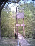 view gallery view galleryS10.1 km |  Little Mac Little Mac
in Pedestrian Suspension Bridges A miniature replica of the Mighty Mackinac Bridge spanning Michigan's two penninsulas. posted by: Screechowl location: Michigan date approved: 10/05/2005 last visited: 05/28/2018 |
 view gallery view gallery E10.8 km E10.8 km
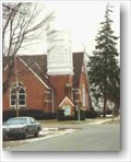
|  Richmond Community Theatre - Richmond, MI Richmond Community Theatre - Richmond, MI
in Live Stage Theaters Richmond Community Theatre operates out of the former First Congregational Church in Richmond, Michigan. posted by: bobfrapples8 location: Michigan date approved: 09/12/2022 last visited: never |
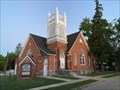
 view gallery view galleryE10.8 km |  First Congregational Church (Richmond, Michigan) First Congregational Church (Richmond, Michigan)
in Wikipedia Entries Richmond Community Theatre operates out of the former First Congregational Church in Richmond, Michigan. posted by: bobfrapples8 location: Michigan date approved: 09/11/2022 last visited: never |
 view gallery view gallery SE10.8 km SE10.8 km
| Richmond Center for the Performing Arts in Michigan Historical Markers Registered Local Historic Site 393. 69619 Parker St.
posted by:  jbrennan jbrennan location: Michigan date approved: 05/12/2006 last visited: 09/11/2022 |
 view gallery view galleryNE10.9 km | "The Thing" in Michigan Historical Markers "The Thing" Boardman Road at east village limits posted by: jbrennan location: Michigan date approved: 05/11/2006 last visited: 09/07/2022 |
 view gallery view galleryE11.1 km | Sanford Stone / Weller House in Michigan Historical Markers Sanford Stone / Weller House 36035 Washington St, Richmond posted by: jbrennan location: Michigan date approved: 05/11/2006 last visited: 09/10/2022 |
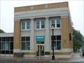 view gallery view gallerySE11.1 km |  National City Bank, Richmond, Michigan National City Bank, Richmond, Michigan
in Civil Defense Fallout Shelters This Shelter is located on Main St. on the North/West corner of Monroe St. in Richmond. posted by: EL1998P71 location: Michigan date approved: 08/25/2007 last visited: 05/29/2018 |
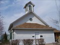 view gallery view galleryE11.3 km |  One Room Schoolhouse One Room Schoolhouse
in Preserved Architectural Remnants and Ruins Part of the Richmond Historic Village located on Park Street in between Stone and Beebe Street. Also just south of the Historical Marker. posted by: The D Zone location: Michigan date approved: 03/21/2012 last visited: 09/10/2022 |
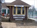 view gallery view galleryE11.3 km | Train Depot in Preserved Architectural Remnants and Ruins Part of the Richmond Historic Village located on Park Street in between Stone and Beebe Street. Also just south of the Historical Marker. posted by: The D Zone location: Michigan date approved: 03/21/2012 last visited: 09/10/2022 |
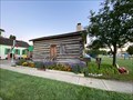
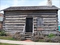 view gallery view galleryE11.3 km | Donley Family Cabin in Preserved Architectural Remnants and Ruins Part of the Richmond Historic Village located on Park Street in between Stone and Beebe Street. Also just south of the Historical Marker. posted by: The D Zone location: Michigan date approved: 03/21/2012 last visited: 09/10/2022 |
 view gallery view galleryE11.3 km |  Donley Farm - Richmond, MI Donley Farm - Richmond, MI
in Michigan Centennial Farms Marker for Donley Farm is located at the Bailey Historic Park at 36045 Park St, Richmond, Michigan 48062 posted by: bobfrapples8 location: Michigan date approved: 09/11/2022 last visited: never |
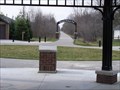 view gallery view gallerySE11.3 km |  Macomb Orchard Trail - Richmond Macomb Orchard Trail - Richmond
in Rails to Trails The start of the Macomb Orchard Trail but from the east. posted by: The D Zone location: Michigan date approved: 03/26/2012 last visited: 05/29/2018 |
 view gallery view gallery W11.4 km W11.4 km
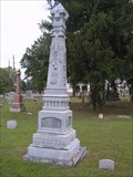
|  Streeter Zinc Headstone - McCafferty Cemetery - Romeo, MI Streeter Zinc Headstone - McCafferty Cemetery - Romeo, MI
in Zinc Headstones Located on the west side of Van Dyke just north of 34 Mile Road. posted by: Team--B location: Michigan date approved: 08/21/2010 last visited: 12/07/2013 |
 view gallery view gallery SW11.9 km SW11.9 km
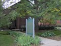
| Village of Romeo in Michigan Historical Markers In front of the Romeo District Library (Kezar Branch) on the west side of North Main Street, between Newberry Road and Church Streets. Parking available at the Library. posted by: S5280ft location: Michigan date approved: 09/17/2006 last visited: 01/06/2014 |
 view gallery view galleryNW12.2 km | Almont Society of the New Church in Michigan Historical Markers A cute church, located on the northeast corner of Cameron and Tubspring Roads. It is fenced off from the road, but the gate was open when we were there. Parking available inside the gate. posted by: S5280ft location: Michigan date approved: 10/08/2006 last visited: 11/02/2014 |
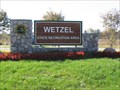 view gallery view galleryS12.4 km |  Wetzel State Recreation Area - Michigan Wetzel State Recreation Area - Michigan
in State/Provincial Parks Welcome to Wetzel State Recreation Area posted by: Lenox location: Michigan date approved: 08/29/2007 last visited: 07/23/2016 |
|