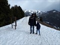
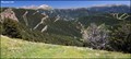
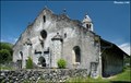
 view gallery view gallery S17.9 km S17.9 km
|   En Roc del Quer - Canillo, Andorra En Roc del Quer - Canillo, Andorra
in Framed Views One frame in this place posted by:  Ariberna Ariberna location: Andorra date approved: 09/25/2020 last visited: 11/17/2022 |
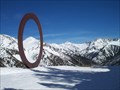 view gallery view gallery SE24.3 km SE24.3 km
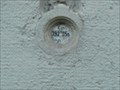
|  Arcalis 91 Arcalis 91
in Abstract Public Sculptures Arcalís 91, un gigantesco aro rojo con doce metros de diámetro, que se eleva en la estación de esquí de Vallnord (Sector de Arcalis). posted by:  falaubabau falaubabau location: Andorra date approved: 04/06/2010 last visited: 06/30/2017 |
 view gallery view gallery SW24.9 km SW24.9 km
|  Gran Encantat (2748.69m) Gran Encantat (2748.69m)
in Vértices Geodésicos Gran Encantat, 2748.69m. posted by: SastRe.O location: Cataluña, Spain date approved: 10/19/2022 last visited: never |
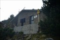 view gallery view gallerySE25.6 km |  Refugi de Les Fonts - La Massana, Andorra Refugi de Les Fonts - La Massana, Andorra
in Remote Backcountry Shelters El refugi de les Fonts és un refugi de muntanya de la Parròquia de La Massana (Andorra) a 2.200 m d'altitud i situat a la Percanela sota el Pic de Les Fonts entre la Coruvilla i Montmantell. posted by: SastRe.O location: Andorra date approved: 11/21/2018 last visited: never |
 view gallery view gallerySE27.2 km |  Andorra from Col de la Botella (Andorra) Andorra from Col de la Botella (Andorra)
in Scenic Overlooks From the Col de la Botella (Pass the Botella) you can see beautiful mountain Landscape of Andorran Pyrenees, which creates the majority of territory of this tiny country... posted by: Dorcadion Team location: Andorra date approved: 09/09/2009 last visited: never |
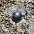
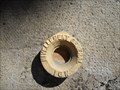
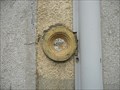 view gallery view gallery N27.2 km N27.2 km
|  Benchmark E.C.O3P3 - 9 - Eycheil Benchmark E.C.O3P3 - 9 - Eycheil
in French Benchmarks Localisation : AU NO 16, ROUTE DES PYRENEES
Partie support : MUR DE FACADE SUD-OUEST DE LA PARTIE CENTRALE, FACE ROUTE
Altitude : 408,025 m posted by: eolas location: Occitanie, France date approved: 02/21/2013 last visited: never |
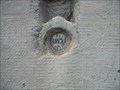 view gallery view galleryN27.5 km | Benchmark E.C.O3P3 - 7 - Saint-Girons in French Benchmarks Localisation : A LA PLAINE D'EYCHEIL, AU NO 72, AVENUE DE LA RESISTANCE
Altitude : 405,245 m posted by: eolas location: Occitanie, France date approved: 02/21/2013 last visited: never |
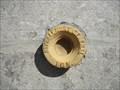
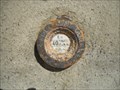 view gallery view galleryN27.7 km | Benchmark E.C.O3P3 - 6 - D.618 - Saint-Girons in French Benchmarks Type : Repère cylindrique
Localisation : Plaine d'Eycheil, 61 Avenue de la Résitance
Partie support : Soubassement du mur pignon sud-ouest, face route
Altitude : 403.25 posted by: eolas location: Occitanie, France date approved: 02/20/2013 last visited: never |
 view gallery view gallery NW28 km NW28 km
|  Church of Our Lady in Luzenac / L'Eglise de Notre-Dame-de-Luzenac-de-Moulis (Ariege, France) Church of Our Lady in Luzenac / L'Eglise de Notre-Dame-de-Luzenac-de-Moulis (Ariege, France)
in Medieval Churches Interesting and in shape very unusual Romanesque church of Our Lady (Eglise de Notre-Dame) you can find in Luzenac, small village in Ariege department in south-western France... posted by: Dorcadion Team location: France date approved: 07/01/2009 last visited: 03/03/2018 |
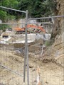 view gallery view galleryN28.2 km |  Carrière de marbre, Aubert Carrière de marbre, Aubert
in Active Quarries Petite carrière située à Aubert qui produit du marbre très prestigieux, nommé "Grand Antique". posted by: 09Naturel location: Occitanie, France date approved: 07/01/2018 last visited: 02/24/2020 |
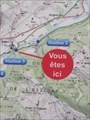 view gallery view galleryN28.3 km |  "Vous êtes ici" - Station 3 du sentier Vél'eau, Aubert "Vous êtes ici" - Station 3 du sentier Vél'eau, Aubert
in 'You Are Here' Maps "Vous êtes ici" sur un panneau explicatif du sentier Vél'eau, station 3, Aubert. posted by: 09Naturel location: Occitanie, France date approved: 06/29/2018 last visited: 06/28/2018 |
 view gallery view gallerySE28.5 km |  Bridge in LLors - Andorra Bridge in LLors - Andorra
in Arch Bridges Bridge in Iron Route posted by: Ariberna location: Andorra date approved: 02/01/2022 last visited: 02/01/2022 |
 view gallery view gallerySE28.5 km |  Bridge in LLors - Andorra Bridge in LLors - Andorra
in Orphaned Bridges Bridge in Iron Route posted by: Ariberna location: Andorra date approved: 01/31/2022 last visited: 02/01/2022 |
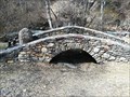 view gallery view gallerySE28.5 km |  Bridge in LLors - Andorra Bridge in LLors - Andorra
in Stone Bridges Bridge in Iron Route posted by: Ariberna location: Andorra date approved: 02/10/2022 last visited: 02/11/2022 |
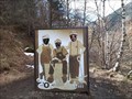
 view gallery view gallerySE28.6 km |  Familia Jordino - Andorra Familia Jordino - Andorra
in Sculpture Gardens Place with seven sculptures posted by: Ariberna location: Andorra date approved: 02/20/2022 last visited: 02/20/2022 |
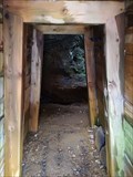 view gallery view gallerySE28.6 km |  Llorts Iron Mine - Ordino, Andorra Llorts Iron Mine - Ordino, Andorra
in Official Local Tourism Attractions The iron mine Llorts is a mine of iron which is Llorts ( Ordino ) and, along with mines and Sedornet Meners de Ransol , fed the forges of Ordino posted by: Ariberna location: Andorra date approved: 08/21/2021 last visited: 08/22/2021 |
 view gallery view gallerySE28.6 km |  Llorts Iron Mine - Ordino, Andorra Llorts Iron Mine - Ordino, Andorra
in Mines The iron mine Llorts is a mine of iron which is Llorts ( Ordino ) and, along with mines and Sedornet Meners de Ransol , fed the forges of Ordino posted by: Ariberna location: Andorra date approved: 08/21/2021 last visited: 08/22/2021 |
 view gallery view gallerySE28.6 km |  Llorts Iron Mine - Ordino, Andorra Llorts Iron Mine - Ordino, Andorra
in Wikipedia Entries The iron mine Llorts is a mine of iron which is Llorts ( Ordino ) and, along with mines and Sedornet Meners de Ransol , fed the forges of Ordino posted by: Ariberna location: Andorra date approved: 08/21/2021 last visited: 08/22/2021 |
 view gallery view gallerySE28.6 km |  Llorts Iron Mine - Ordino, Andorra Llorts Iron Mine - Ordino, Andorra
in History Museums museum of iron work in the mine posted by: Ariberna location: Andorra date approved: 08/21/2021 last visited: 08/22/2021 |
 view gallery view gallerySE28.6 km |  I am a miner! - Ordino, Andorra I am a miner! - Ordino, Andorra
in Photo Cutouts Take a picture as if you were a miner posted by: Ariberna location: Andorra date approved: 08/23/2021 last visited: 08/25/2021 |
 view gallery view galleryN28.8 km | Benchmark E.C.O3P3 - 4 - D.618 - Saint-Girons in French Benchmarks Type : Repère cylindrique de nivellement
Localisation : à 15 mètres au sud-est du carrefour avec la rue Morinière
Altitude : 398.94 posted by: eolas location: Occitanie, France date approved: 02/20/2013 last visited: never |
 view gallery view galleryN28.8 km | Benchmark E.C.P3 - 3 - D.117 - Saint-Girons in French Benchmarks Type : repère cylindrique nivellement
Localisation : pont D117
Altitude : 391.45 posted by: eolas location: Occitanie, France date approved: 02/20/2013 last visited: never |
 view gallery view galleryN29.1 km | Benchmark E.C.O3P3 - 3 - Saint-Girons in French Benchmarks Voie suivie : AVENUE GALLIENI (D.618) - 24
Partie support : SOUBASSEMENT DU MUR DE FACADE EST, FACE AVENUE
Altitude : 392.34 posted by: eolas location: Occitanie, France date approved: 02/20/2013 last visited: never |
 view gallery view galleryN29.1 km | Benchmark E.C.O3P3 - 2 - Saint-Girons in French Benchmarks Localisation : AU CARREFOUR AVEC LE BOULEVARD PEYREVIDOL
Partie support : MUR DE FACADE SUD-OUEST, FACE RUE DESBIAUX
Altitude : 392,194 m posted by: eolas location: Occitanie, France date approved: 02/20/2013 last visited: never |
 view gallery view galleryN29.1 km | Benchmark E.C.O3P3 - 1 - Saint-Girons in French Benchmarks Support : ECOLE PAUL SAINT-ALARY
Partie support : SOUBASSEMENT DU MUR DE FACADE SUD-OUEST, FACE PLACE
Altitude : 391,825 m posted by: eolas location: Occitanie, France date approved: 02/20/2013 last visited: never |
|