 view gallery view gallery E0.3 km E0.3 km
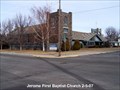
|   Jerome First Baptist Church Jerome First Baptist Church
in U.S. National Register of Historic Places If you like older churches, this is one to see. posted by:  greywolf1242 greywolf1242 location: Idaho date approved: 02/05/2007 last visited: 08/14/2015 |
 view gallery view gallery SE0.5 km SE0.5 km
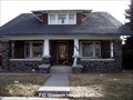
| F.C. Gleason House in U.S. National Register of Historic Places This is a good example of the craftsman style houses built in the area. posted by: greywolf1242 location: Idaho date approved: 02/05/2007 last visited: 04/15/2011 |
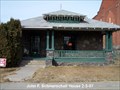 view gallery view gallerySE0.5 km | Schmerschall, John F., House in U.S. National Register of Historic Places One of a number of craftsman style houses with H.T. Pugh's influence. posted by: greywolf1242 location: Idaho date approved: 02/05/2007 last visited: 08/14/2015 |
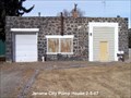 view gallery view gallerySE1 km | Jerome City Pump House in U.S. National Register of Historic Places Although not a house, H.T. Pugh, along with Ed Bennett, was involved with the construction of this building for commercial use. posted by: greywolf1242 location: Idaho date approved: 02/05/2007 last visited: 04/15/2011 |
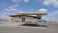 view gallery view gallerySE9.2 km |  Junction US 93 Rest Area ~ Eastbound Junction US 93 Rest Area ~ Eastbound
in Highway Rest Areas This Highway Rest Area is located on the south side of Interstate Highway 84 at Milepost 171 southeast of Jerome, Idaho. posted by:  brwhiz brwhiz location: Idaho date approved: 02/02/2013 last visited: never |
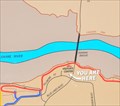
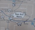 view gallery view gallerySE9.2 km |  Junction US 93 Eastbound Rest Area Junction US 93 Eastbound Rest Area
in 'You Are Here' Maps You Are Here at the Junction US 93 Eastbound Rest Area on the south side of Interstate Highway 84 at Milepost 171, just south of Jerome, Idaho. posted by: brwhiz location: Idaho date approved: 02/02/2013 last visited: never |
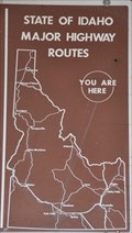 view gallery view gallerySE9.2 km | Junction US 93 Eastbound Rest Area Restrooms in 'You Are Here' Maps You Are Here at the restrooms at the Junction US 93 Eastbound Rest Area on the south side of Interstate Highway 84 at Milepost 171, just southeast of Jerome, Idaho. posted by: brwhiz location: Idaho date approved: 02/02/2013 last visited: never |
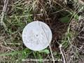
 view gallery view gallery NE9.3 km NE9.3 km
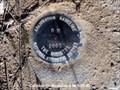
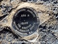
|  Calibration Baseline 0 M Calibration Baseline 0 M
in U.S. Benchmarks This is a National Geodetic Survey Marker. posted by: greywolf1242 location: Idaho date approved: 01/23/2007 last visited: never |
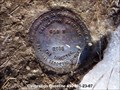
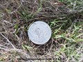
 view gallery view galleryNE9.5 km | Calibration Baseline BM 150 M in U.S. Benchmarks This is a National Geodetic survey marker. posted by: greywolf1242 location: Idaho date approved: 01/23/2007 last visited: never |
 view gallery view galleryNE9.7 km | Calibration Baseline 480 M in U.S. Benchmarks This is a National Geodetic Society Survey Marker. posted by: greywolf1242 location: Idaho date approved: 01/23/2007 last visited: never |
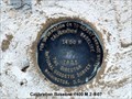 view gallery view galleryNE10.5 km | Calibration Baselinge 1400 M in U.S. Benchmarks This is a calibration marker. posted by: greywolf1242 location: Idaho date approved: 02/05/2007 last visited: never |
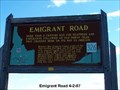 view gallery view gallerySE13 km |  Emigrant Road Emigrant Road
in Idaho Historical Markers Hudson's Bay Company traders preferred this route between Fort Hall and Fort Boise. posted by: greywolf1242 location: Idaho date approved: 04/02/2007 last visited: 05/30/2008 |
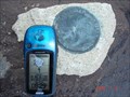
 view gallery view gallerySE14.2 km | Idaho Transportation Dept. # 6 in U.S. Benchmarks This is an Idaho Trasportation Dept R/W marker. posted by: greywolf1242 location: Idaho date approved: 03/09/2007 last visited: never |
 view gallery view gallerySE14.2 km | Idaho Transportation Dept. # 5 in U.S. Benchmarks This is an Idaho Transportation Dept. R/W marker. posted by: greywolf1242 location: Idaho date approved: 03/09/2007 last visited: 11/29/2011 |
 view gallery view gallery S14.8 km S14.8 km
| Idaho State Highway survey marker in U.S. Benchmarks State of Idaho Highway survey marker. posted by: salvager location: Idaho date approved: 07/09/2007 last visited: 11/28/2011 |
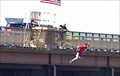 view gallery view galleryS15 km |  Perrine's Bridge, Twin Falls, Idaho Perrine's Bridge, Twin Falls, Idaho
in Bungee Jump Sites A 500 ft. free fall towards the Snake river with over 200ft. of cord! Just down from where Evil Knievel tried to jump the canyon.
posted by: Bernd das Brot Team location: Idaho date approved: 07/20/2006 last visited: 04/16/2023 |
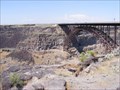
 view gallery view galleryS15 km |  I.B. Perrine Bridge - Twin Falls, Idaho I.B. Perrine Bridge - Twin Falls, Idaho
in Arch Bridges The I.B. Perrine Bridge across the Snake River at Twin Falls, Idaho. posted by: Volcanoguy location: Idaho date approved: 07/10/2011 last visited: 05/08/2023 |
 view gallery view galleryS15 km |  Perrine Bridge - Twin Falls ID Perrine Bridge - Twin Falls ID
in Wikipedia Entries The I. B. Perrine Bridge is a four-lane truss arch span in the western United States. Located at Twin Falls, Idaho, it carries U.S. Highway 93 over the Snake River Canyon, connecting to Jerome County and Interstate 84. posted by: Don.Morfe location: Idaho date approved: 11/22/2022 last visited: 12/24/2022 |
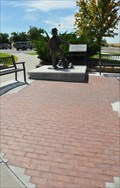
 view gallery view galleryS15.1 km |  Buzz Langdon Visitor Center Buzz Langdon Visitor Center
in Scenic Roadside Look-Outs This Roadside Lookout is a concrete platform built out over the Snake River Gorge at the Buzz Langdon Visitor Center on the south end of the I.B. Perrine Memorial Bridge on the north edge of Twin Falls, Idaho. posted by: brwhiz location: Idaho date approved: 12/03/2012 last visited: 04/16/2023 |
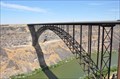 view gallery view galleryS15.1 km |  Perrine Memorial Bridge Perrine Memorial Bridge
in Truss Bridges This Arch-Truss Bridge carries US Highway 93 across the Snake River Gorge on the north side of Twin Falls, Idaho. posted by: brwhiz location: Idaho date approved: 12/03/2012 last visited: 04/16/2023 |
 view gallery view galleryS15.1 km |  Buzz Langdon Visitor Center Buzz Langdon Visitor Center
in Official Local Tourism Attractions This Official Local Tourism Attraction is on the south end of the I.B. Perrine Memorial Bridge on the north edge of Twin Falls, Idaho. posted by: brwhiz location: Idaho date approved: 12/03/2012 last visited: 04/16/2023 |
 view gallery view galleryS15.1 km |  Thousand Springs Scenic Byway ~ Perrine Memorial Bridge Thousand Springs Scenic Byway ~ Perrine Memorial Bridge
in National Scenic Byways The Perrine Memorial Bridge is Stop Number 7 on the Thousand Springs Scenic Byway in Idaho. posted by: brwhiz location: Idaho date approved: 12/04/2012 last visited: 04/16/2023 |
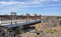
 view gallery view galleryS15.1 km |  Ira Burton Perrine Memorial Ira Burton Perrine Memorial
in Donated Engraved Bricks and Pavers These donor bricks are for the Ira Burton Perrine Memorial at the south end of the I.B. Memorial Bridge. posted by: brwhiz location: Idaho date approved: 12/03/2012 last visited: 12/24/2022 |
 view gallery view galleryS15.1 km | Buzz Langdon Visitor Center in 'You Are Here' Maps You Are Here at the Buzz Langdon Visitor Center at the south end if the I.B. Perrine Memoral Bridge on the north edge of Twin Falls, Idaho. posted by: brwhiz location: Idaho date approved: 12/03/2012 last visited: 08/31/2018 |
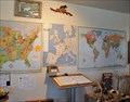 view gallery view galleryS15.1 km |  Buzz Langdon Visitor Center Guest Book Buzz Langdon Visitor Center Guest Book
in Guest Books This Guest Book is located in the Buzz Langdon Visitor Center on the south end of the I.B. Perrine Memorial Bridge on the north edge of Twin Falls, Idaho. posted by: brwhiz location: Idaho date approved: 12/03/2012 last visited: 08/31/2018 |
|