 view gallery view gallery NE3.7 km NE3.7 km
|   Pico Pacino (Huesca) Pico Pacino (Huesca)
in Vértices Geodésicos Vertice situado en el Pico Pacino, en Sallent de Gállego (Huesca) posted by:  jcast jcast location: Aragón, Spain date approved: 04/16/2006 last visited: never |
 view gallery view gallery NW18.7 km NW18.7 km
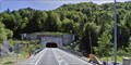
|  Tunnel du Somport - France/Espagne Tunnel du Somport - France/Espagne
in Border Crossings Entrée du tunnel du Somport à la fontière Franco-espagnole posted by:  pilouille pilouille location: Pays de la Loire, France date approved: 04/02/2015 last visited: 06/23/2019 |
 view gallery view gallery N19.2 km N19.2 km
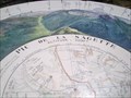
|  Pic de la Sagette Pic de la Sagette
in Named Mountain Gaps Pic de la Sagette 2030 mètres. posted by: lulu_et_compagnie location: Nouvelle-Aquitaine, France date approved: 04/08/2022 last visited: 04/09/2022 |
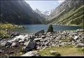 view gallery view galleryNE22.2 km |  Lac de Gaube / Gaube Lake - Pyrenees (France) Lac de Gaube / Gaube Lake - Pyrenees (France)
in Natural Lakes Small glacial Lac de Gaube (Gaube Lake), located close to the Pont d’Espagne in Pyrenees Mts., belongs among the most pictoresques lakes of the Pyrenees National Park... posted by: Dorcadion Team location: Occitanie, France date approved: 08/25/2014 last visited: 09/09/2023 |
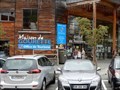
 view gallery view gallery SW22.2 km SW22.2 km
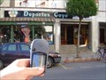
|  Goyo Goyo
in Bicycle Shops Tienda de bicicletas y material para esquiar. posted by: >fetiche< location: Aragón, Spain date approved: 09/07/2006 last visited: never |
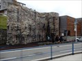
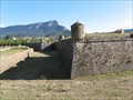 view gallery view gallerySW22.9 km |  La Ciudadela La Ciudadela
in Castles Militar Castle located in Jaca (Spain) posted by: jcast location: Aragón, Spain date approved: 08/18/2006 last visited: 07/05/2019 |
 view gallery view gallerySW22.9 km |  Catedral de Jaca Catedral de Jaca
in Web Cameras Webcam cache, en el que hay que colocarse en las coordenas indicadas y registralo junto con la foto de tu presencia en el lugar. posted by: geosanmon location: Aragón, Spain date approved: 03/07/2011 last visited: never |
 view gallery view gallery S23 km S23 km
| Navasa in Bicycle Shops En el centro de Sabiñánigo posted by: >fetiche< location: Aragón, Spain date approved: 09/07/2006 last visited: never |
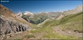 view gallery view gallery E24.8 km E24.8 km
|  Ara Valley from Puerto de Bujaruelo (Pyrennes Mts., Spain) Ara Valley from Puerto de Bujaruelo (Pyrennes Mts., Spain)
in Scenic Overlooks Beautiful vista over Ara valley in Aragonian part of Pyrenees Mts. you can find couple meters from French-Spain borders, in mountain pass called Puerto de Bujaruelo... posted by: Dorcadion Team location: Aragón, Spain date approved: 09/09/2009 last visited: 03/06/2014 |
 view gallery view galleryE25.9 km | Col de Tentes - Refuge des Sarradets (Pyrennes Mts., France) in Scenic Hikes Short, but magnificent vistas offering trail from parking at Col de Tentes (2200 m) to Refuge des Sarradets (2600 m) in Pyrennes Mountains, is a perfect 1/2 day program for any mountains lover... posted by: Dorcadion Team location: Occitanie, France date approved: 06/26/2009 last visited: 08/01/2019 |
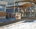 view gallery view galleryN25.9 km |  Télécabine du Bézou - Gourette, Aquitaine/Pyrénées-Atlantiques, France Télécabine du Bézou - Gourette, Aquitaine/Pyrénées-Atlantiques, France
in Aerial Lifts Télécabine du Bézou posted by: pilouille location: Nouvelle-Aquitaine, France date approved: 04/01/2015 last visited: 09/04/2021 |
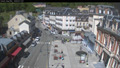
 view gallery view galleryN26.1 km |  Office de Tourisme Gourette - Eaux Bonnes, Nouvelle Aquitaine, France Office de Tourisme Gourette - Eaux Bonnes, Nouvelle Aquitaine, France
in Tourist Information Centers - Visitor Centers In the town center.
Dans le centre Ville. posted by: sara et gege location: Nouvelle-Aquitaine, France date approved: 09/19/2019 last visited: 12/31/2019 |
 view gallery view galleryN26.1 km |  Mur escalade Gourette - Eaux Bonnes, Nouvelle Aquitaine, France Mur escalade Gourette - Eaux Bonnes, Nouvelle Aquitaine, France
in Artificial Climbing Walls In the town center
Dans le centre ville. posted by: sara et gege location: Nouvelle-Aquitaine, France date approved: 09/18/2019 last visited: 12/31/2019 |
 view gallery view galleryN26.1 km |  Gourette - Aquitaine/Pyrénées-Atlantiques, France Gourette - Aquitaine/Pyrénées-Atlantiques, France
in Winter Sports Locations Station de ski Gourette posted by: pilouille location: Pays de la Loire, France date approved: 03/29/2015 last visited: 09/04/2021 |
 view gallery view galleryNE27.5 km | Webcam Cauterets (65) in Web Cameras Webcam de Cauterets - Village posted by: JulieDavy location: Occitanie, France date approved: 05/31/2019 last visited: never |
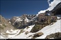 view gallery view galleryE27.5 km |  Refuge des Sarradets - Pyrenees Mts. (France) Refuge des Sarradets - Pyrenees Mts. (France)
in Remote Backcountry Shelters Depicted chalet "Refuge des Sarradets" is mountain refuge (altitude 2 587 m) located in the heart of Pyrénées National Park, close to the stunning Cirque Gavarnie and under mythic Brèche de Roland at French-Spanish border... posted by: Dorcadion Team location: Occitanie, France date approved: 08/21/2014 last visited: 06/05/2022 |
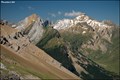
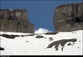 view gallery view galleryE27.5 km |  La Brèche de Roland - Pyrenees Mts. (France) La Brèche de Roland - Pyrenees Mts. (France)
in Wikipedia Entries La Brèche de Roland is a natural gap, 40 m wide and 100 m high at an elevation of 2804 m, located in the Pyrenees Mts. on the border of Aragón, northern Spain and Hautes-Pyrénées, France. posted by: Dorcadion Team location: Occitanie, France date approved: 08/20/2014 last visited: 08/01/2019 |
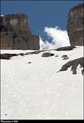 view gallery view galleryE27.5 km | La Brèche de Roland / Roland's Gap - Pyrenees Mts. (France) in Named Mountain Gaps La Brèche de Roland (Roland's Gap) is a natural mountain gap, 40 m wide and 100 m high at an elevation of 2804 m, located in the Pyrenees Mts. on the French-Spanish borders. posted by: Dorcadion Team location: Occitanie, France date approved: 08/21/2014 last visited: 06/05/2022 |
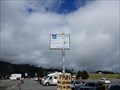
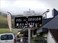 view gallery view galleryN27.5 km |  1474 m - col du Soulor - Arrens Marsous, Occitanie, France 1474 m - col du Soulor - Arrens Marsous, Occitanie, France
in Elevation Signs le col du Soulor posted by: sara et gege location: Occitanie, France date approved: 08/22/2019 last visited: 11/28/2019 |
 view gallery view galleryN27.5 km | Col du Soulor - Arbeost, Occitanie, France in Wikipedia Entries the panels are at the neck of Soulor.
les panneaux sont au col du Soulor. posted by: sara et gege location: Occitanie, France date approved: 09/17/2019 last visited: 12/29/2019 |
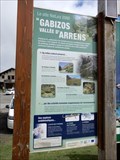 view gallery view galleryN27.5 km |  Col du Soulor site Natura 2000 - Arbeost, Occitanie, France Col du Soulor site Natura 2000 - Arbeost, Occitanie, France
in Flora and Fauna Information Signs the panels are at the neck of Soulor.
les panneaux sont au col du Soulor. posted by: sara et gege location: Occitanie, France date approved: 09/16/2019 last visited: 12/29/2019 |
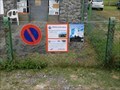 view gallery view galleryN27.5 km | Col du Soulor Faune Migration, Arbeost, Occitanie, France in Flora and Fauna Information Signs The panels are at the neck of Soulor.
Les panneaux sont au col du Soulor. posted by: sara et gege location: Occitanie, France date approved: 09/16/2019 last visited: 12/29/2019 |
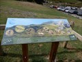 view gallery view galleryN27.5 km | Col du Soulor Faune, Arbeost, Occitanie, France in Flora and Fauna Information Signs The panels are at the neck of Soulor.
Les panneaux sont au col du Soulor. posted by: sara et gege location: Occitanie, France date approved: 09/16/2019 last visited: 12/29/2019 |
 view gallery view galleryN27.5 km |  Tyrolienne Deval Cable Col du Soulor - Arbeost, Occitanie, France Tyrolienne Deval Cable Col du Soulor - Arbeost, Occitanie, France
in Zip-line the zipline is at the neck of Soulor.
La tyrolienne est au col du Soulor. posted by: sara et gege location: Occitanie, France date approved: 09/19/2019 last visited: 12/29/2019 |
 view gallery view galleryN27.7 km | Col du Soulor Migrer, Arbeost, Occitanie, France in Flora and Fauna Information Signs the panels are at the neck of Soulor.
les panneaux sont au col du Soulor. posted by: sara et gege location: Occitanie, France date approved: 09/16/2019 last visited: 12/29/2019 |
|