 view gallery view gallery W1 km W1 km
|   Basketball Court at Bicentennial Field Complex - Tyngsboro, Massachusetts Basketball Court at Bicentennial Field Complex - Tyngsboro, Massachusetts
in Outdoor Basketball Courts This basketball court with two hoops is part of the Bicentennial Field Complex in Tyngsboro, Massachusetts. It is oriented northwest/southeast and is not lit for nighttime use. posted by:  401Photos 401Photos location: Massachusetts date approved: 06/07/2021 last visited: never |
 view gallery view gallery S1.1 km S1.1 km
|  The Butterfly Place The Butterfly Place
in Butterfly Houses An atrium-style butterfly house in Westford Massachusetts posted by:  cache_test_dummies cache_test_dummies location: Massachusetts date approved: 09/13/2005 last visited: 05/19/2012 |
 view gallery view gallery N2.9 km N2.9 km
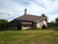
|  TYNGSBOROUGH - Tyngsborough, MA TYNGSBOROUGH - Tyngsborough, MA
in American Guide Series At the 2020 census, the town population was 12,380. By its location, the town serves as a suburb of neighboring cities such as Nashua, New Hampshire and Lowell, Massachusetts. posted by: nomadwillie location: Massachusetts date approved: 02/04/2023 last visited: never |
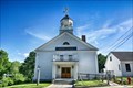
 view gallery view galleryN2.9 km |  Old Town Hall (Tyngsborough, Massachusetts) Old Town Hall (Tyngsborough, Massachusetts)
in Wikipedia Entries Tyngsborough’s Old Town Hall is a wood-framed Federal style building built ca. 1834. The former Baptist church was adapted for use as the Town Hall in 1864, a purpose it served until 1998. posted by: nomadwillie location: Massachusetts date approved: 02/04/2023 last visited: never |
 view gallery view galleryN2.9 km | Tyngsborough, Massachusetts in Wikipedia Entries Tyngsborough (also spelled Tyngsboro) is a town in northern Middlesex County, Massachusetts, United States. Tyngsborough is 28 miles (45 km) from Boston along the Route 3 corridor, and located on the New Hampshire state line. posted by: nomadwillie location: Massachusetts date approved: 02/04/2023 last visited: never |
 view gallery view galleryN2.9 km |  Old Town Hall - Tyngsborough MA Old Town Hall - Tyngsborough MA
in U.S. National Register of Historic Places Tyngsborough’s Old Town Hall is a wood-framed Federal style building built ca. 1834. The former Baptist church was adapted for use as the Town Hall in 1864, a purpose it served until 1998. posted by: nomadwillie location: Massachusetts date approved: 02/04/2023 last visited: never |
 view gallery view galleryN2.9 km |  Baptist Church (historic) - Tyngsborough, MA Baptist Church (historic) - Tyngsborough, MA
in This Old Church The Baptist Church is wood-frame building was built in 1834 as a church to house the local Baptist congregation, a role it served until 1857, when it was sold to the town. posted by: nomadwillie location: Massachusetts date approved: 02/04/2023 last visited: never |
 view gallery view gallery NE2.9 km NE2.9 km
|  Tyngsborough replacement temporary bridge Tyngsborough replacement temporary bridge
in Bailey Bridges Two bridges, side-by-side, spanning the Merrimack River.
One is a regal symbol of a community, its green arches in harmony with the lush scenery. The other, a temporary blemish to the landscape.
posted by: Mountain_Wanderer location: Massachusetts date approved: 10/07/2008 last visited: 09/02/2012 |
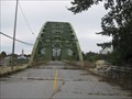 view gallery view galleryNE2.9 km |  Tyngsborough Bridge Tyngsborough Bridge
in Arch Bridges Replaced a 4-span iron whipple truss bridge built 1873. posted by: Mountain_Wanderer location: Massachusetts date approved: 10/08/2008 last visited: 12/05/2012 |
 view gallery view gallery SE3.2 km SE3.2 km
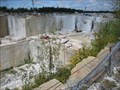
|  Fletcher Granite Company - Westford, MA Fletcher Granite Company - Westford, MA
in Active Quarries The Fletcher Granite quarry in Westford provides many kinds of landscaping and building products made with a grey granite that has many flecks of mica. posted by: NorStar location: Massachusetts date approved: 10/02/2009 last visited: 09/29/2019 |
 view gallery view gallery E3.4 km E3.4 km
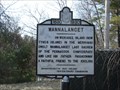
|  Wannalancet - Lowell, MA Wannalancet - Lowell, MA
in Massachusetts Historical Markers This historical marker about Wannalancet is located along Pawtucket Boulevard (Route 113) at the Vesper Country Club in Lowell, Massachusetts. posted by: Marine Biologist location: Massachusetts date approved: 03/29/2009 last visited: 03/27/2009 |
 view gallery view galleryN3.5 km |  60 AA (MAGS, Tyngsborough, MA) 60 AA (MAGS, Tyngsborough, MA)
in U.S. Benchmarks A monel rivet mark located in Tyngsborough, MA.
The MHD ID# is 16140 posted by: NH2beers location: Massachusetts date approved: 10/11/2010 last visited: never |
 view gallery view galleryS3.7 km | MY2189: N 18 (NGS, Westford, MA) in U.S. Benchmarks A NGS standard vertical control disk, located in Westford, MA.
The NGS PID# is MY2189.
The MHD ID# is 23231. posted by: NH2beers location: Massachusetts date approved: 07/22/2011 last visited: never |
 view gallery view galleryN4 km |  Skate 3 Roller Kingdom - Tyngsboro, MA Skate 3 Roller Kingdom - Tyngsboro, MA
in Roller Skating Rinks A roller rink in a building that also has 2 ice skating rinks. posted by: Mountain_Wanderer location: Massachusetts date approved: 10/07/2008 last visited: 10/04/2011 |
 view gallery view gallery NW4.5 km NW4.5 km
|  Dunstable, MA Dunstable, MA
in City and Town Halls Also known as Sarah R.S. Robey Memorial Building, prominently situated on the Dunstable town green, the building is a reflection of the community’s civic pride in the early 20th century. posted by: nomadwillie location: Massachusetts date approved: 07/02/2013 last visited: never |
 view gallery view galleryNW4.5 km |  1907 - Dunstable Town Hall - Dunstable, MA 1907 - Dunstable Town Hall - Dunstable, MA
in Dated Buildings and Cornerstones Also known as Sarah R.S. Robey Memorial Building, prominently situated on the Dunstable town green, the building is a reflection of the community’s civic pride in the early 20th century. posted by: nomadwillie location: Massachusetts date approved: 06/27/2013 last visited: never |
 view gallery view galleryNW4.5 km | Dunstable Town Hall - Dunstable, MA in U.S. National Register of Historic Places Also known as Sarah R.S. Robey Memorial Building, prominently situated on the Dunstable town green, the building is a reflection of the community’s civic pride in the early 20th century. posted by: nomadwillie location: Massachusetts date approved: 06/25/2013 last visited: never |
 view gallery view galleryNW4.5 km | 60 AC (MADPW/MAGS, Dunstable, MA) in U.S. Benchmarks A MassDPW standard bench mark disk located in Dunstable, MA.
The MHD ID# is 16142. posted by: NH2beers location: Massachusetts date approved: 10/23/2010 last visited: never |
 view gallery view galleryE5.3 km |  Lowell First Church of the Nazarene - Lowell, MA Lowell First Church of the Nazarene - Lowell, MA
in Church of the Nazarene The Church of the Nazarene in Lowell, Massachusetts. posted by: Strattonator location: Massachusetts date approved: 06/11/2013 last visited: never |
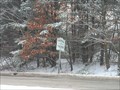 view gallery view galleryN5.5 km |  Route 3 MA to NH Route 3 MA to NH
in Border Crossings The sign at the MA/NH border on Route 3 between Nashua and Tyngsboro, MA posted by: Mountain_Wanderer location: New Hampshire date approved: 01/05/2006 last visited: never |
 view gallery view gallery SW5.5 km SW5.5 km
|  Wright Cemetery - Westford MA USA Wright Cemetery - Westford MA USA
in Worldwide Cemeteries The town of Westford granted the privilege of a burying ground on Groton Road (then called the North Road) in 1836. posted by: nomadwillie location: Massachusetts date approved: 06/27/2013 last visited: 08/21/2017 |
 view gallery view gallerySW5.5 km | Wright Cemetery - Westford MA in U.S. National Register of Historic Places The town of Westford granted the privilege of a burying ground on Groton Road (then called the North Road) in 1836. posted by: nomadwillie location: Massachusetts date approved: 06/25/2013 last visited: 08/21/2017 |
 view gallery view galleryN5.5 km | Welcome To New Hampshire in Border Crossings Welcome to New Hampshire sign on border between NH and MA on route 3A. posted by: cache_test_dummies location: New Hampshire date approved: 09/04/2005 last visited: never |
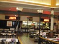 view gallery view galleryN5.5 km |  Arby's- Pheasant Lane Mall- Nashua, NH Arby's- Pheasant Lane Mall- Nashua, NH
in Arby's Restaurants In the food court of the mall. posted by: Mountain_Wanderer location: New Hampshire date approved: 09/04/2008 last visited: never |
 view gallery view galleryS5.5 km | TBM 394 (MAGS, Westford, MA) in U.S. Benchmarks A copper rivet, located on a railroad bridge, in Westford, MA. This is the same bridge that has survey disk 44 J set in it (See).
The MHD ID# is 10180. posted by: NH2beers location: Massachusetts date approved: 07/19/2011 last visited: never |
|