 view gallery view gallery SW5.1 km SW5.1 km
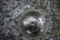
|   Pic de Comaloforno (3029.18m) Pic de Comaloforno (3029.18m)
in Vértices Geodésicos Pic de Comaloforno, 3029.18m, sostre comarcal de l'Alta Ribagorça.
[ENG] Comaloforno peak, 3029.18m, Alta Ribagorça's county summit. posted by:  SastRe.O SastRe.O location: Cataluña, Spain date approved: 03/15/2017 last visited: never |
 view gallery view gallery SE15.1 km SE15.1 km
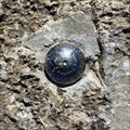
| Gran Encantat (2748.69m) in Vértices Geodésicos Gran Encantat, 2748.69m. posted by: SastRe.O location: Cataluña, Spain date approved: 10/19/2022 last visited: never |
 view gallery view gallery W16.3 km W16.3 km
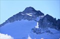
|  Pico Aneto - Highest Point of "Pirineus" Pico Aneto - Highest Point of "Pirineus"
in Geographic High Points El Aneto es el pico más elevado de los Pirineos, con una altitud de 3.404 metros sobre el nivel del mar. posted by:  Galleda Galleda location: Spain date approved: 10/13/2008 last visited: never |
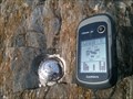 view gallery view gallerySE31.1 km | Rialp in Vértices Geodésicos Punt situat en el Castell de Rialp. posted by: Soniettte location: Cataluña, Spain date approved: 11/12/2013 last visited: 12/12/2013 |
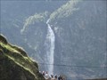 view gallery view galleryW31.4 km |  Cascade d’Oô - Oô - Haute-Garonne, Pyrenees - France Cascade d’Oô - Oô - Haute-Garonne, Pyrenees - France
in Waterfalls Cascade d’Oô posted by: CADS11 location: Occitanie, France date approved: 11/16/2016 last visited: 08/28/2022 |
 view gallery view gallery NW32.2 km NW32.2 km
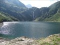
|  Lac dOo - Oô - Haute-Garonne, Pyrenees - France Lac dOo - Oô - Haute-Garonne, Pyrenees - France
in Wikipedia Entries Lac dOo posted by: CADS11 location: Occitanie, France date approved: 11/16/2016 last visited: 08/28/2022 |
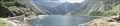 view gallery view galleryNW32.2 km |  Lac dOo - Oô - Haute-Garonne, Pyrenees - France Lac dOo - Oô - Haute-Garonne, Pyrenees - France
in Water Dams Lac dOo posted by: CADS11 location: Occitanie, France date approved: 11/17/2016 last visited: 08/28/2022 |
 view gallery view gallery E33.6 km E33.6 km
|  En Roc del Quer - Canillo, Andorra En Roc del Quer - Canillo, Andorra
in Framed Views One frame in this place posted by: Ariberna location: Andorra date approved: 09/25/2020 last visited: 11/17/2022 |
 view gallery view gallery NE40.1 km NE40.1 km
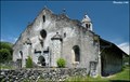
|  Church of Our Lady in Luzenac / L'Eglise de Notre-Dame-de-Luzenac-de-Moulis (Ariege, France) Church of Our Lady in Luzenac / L'Eglise de Notre-Dame-de-Luzenac-de-Moulis (Ariege, France)
in Medieval Churches Interesting and in shape very unusual Romanesque church of Our Lady (Eglise de Notre-Dame) you can find in Luzenac, small village in Ariege department in south-western France... posted by: Dorcadion Team location: France date approved: 07/01/2009 last visited: 03/03/2018 |
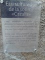 view gallery view galleryNW40.9 km |  Source Cazalis. Loudenvieille. France Source Cazalis. Loudenvieille. France
in Hot Springs Source d'eau chaude de Cazalis posted by: lulu_et_compagnie location: Occitanie, France date approved: 03/30/2017 last visited: 03/30/2017 |
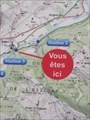 view gallery view galleryNE42 km |  "Vous êtes ici" - Station 3 du sentier Vél'eau, Aubert "Vous êtes ici" - Station 3 du sentier Vél'eau, Aubert
in 'You Are Here' Maps "Vous êtes ici" sur un panneau explicatif du sentier Vél'eau, station 3, Aubert. posted by: 09Naturel location: Occitanie, France date approved: 06/29/2018 last visited: 06/28/2018 |
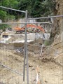 view gallery view galleryNE42.2 km |  Carrière de marbre, Aubert Carrière de marbre, Aubert
in Active Quarries Petite carrière située à Aubert qui produit du marbre très prestigieux, nommé "Grand Antique". posted by: 09Naturel location: Occitanie, France date approved: 07/01/2018 last visited: 02/24/2020 |
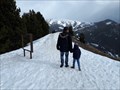
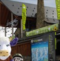 view gallery view galleryW42.3 km |  Formigal - Arágon, Spain Formigal - Arágon, Spain
in Winter Sports Locations Formigal, officially called Aramón Formigal, is a ski resort situated near the town of Sallent de Gallego in the upper Tena Valley of the western Pyrenees (province of Huesca, Spain). posted by: tmob location: Aragón, Spain date approved: 03/23/2011 last visited: never |
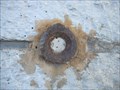
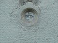
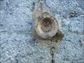
 view gallery view galleryNE44.7 km |  Benchmark - Eglise de Lédar Benchmark - Eglise de Lédar
in French Benchmarks Localisation : EGLISE
Partie support : MUR DE FACADE SUD-EST DE LA NEF, FACE ROUTE
Altitude : 400,198 m posted by: eolas location: Occitanie, France date approved: 02/20/2013 last visited: never |
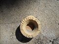
 view gallery view galleryNE45.1 km | Benchmark E.C.O3P3 - 7 - Saint-Girons in French Benchmarks Localisation : A LA PLAINE D'EYCHEIL, AU NO 72, AVENUE DE LA RESISTANCE
Altitude : 405,245 m posted by: eolas location: Occitanie, France date approved: 02/21/2013 last visited: never |
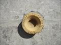
 view gallery view galleryNE45.1 km | Benchmark E.C.O3P3 - 6 - D.618 - Saint-Girons in French Benchmarks Type : Repère cylindrique
Localisation : Plaine d'Eycheil, 61 Avenue de la Résitance
Partie support : Soubassement du mur pignon sud-ouest, face route
Altitude : 403.25 posted by: eolas location: Occitanie, France date approved: 02/20/2013 last visited: never |
 view gallery view galleryNE45.1 km | Benchmark E.C.O3P3 - 9 - Eycheil in French Benchmarks Localisation : AU NO 16, ROUTE DES PYRENEES
Partie support : MUR DE FACADE SUD-OUEST DE LA PARTIE CENTRALE, FACE ROUTE
Altitude : 408,025 m posted by: eolas location: Occitanie, France date approved: 02/21/2013 last visited: never |
 view gallery view galleryNE45.1 km | Benchmark - E.C.N3O3 - 36 - Saint-Girons in French Benchmarks Localisation : AVENUE DU MARECHAL FOCH (D.618)
AU QUARTIER LEDAR, AU NO 43, AVENUE DU MARECHAL FOCH
Altitude : 397,006 m posted by: eolas location: Occitanie, France date approved: 02/20/2013 last visited: never |
 view gallery view galleryNE45.2 km | Benchmark E.C.O3P3 - 4 - D.618 - Saint-Girons in French Benchmarks Type : Repère cylindrique de nivellement
Localisation : à 15 mètres au sud-est du carrefour avec la rue Morinière
Altitude : 398.94 posted by: eolas location: Occitanie, France date approved: 02/20/2013 last visited: never |
 view gallery view galleryNE45.2 km | Benchmark - E.C.N3O3 - 37 - Saint-Girons in French Benchmarks Localisation : AU QUARTIER DE LEDAR, AU NO 19, AVENUE DU MARECHAL FOCH
Partie support : SOUBASSEMENT DU MUR PIGNON NORD-OUEST, FACE ROUTE
Altitude : 394,549 m posted by: eolas location: Occitanie, France date approved: 02/20/2013 last visited: never |
 view gallery view galleryNE45.4 km | Benchmark E.C.P3 - 3 - D.117 - Saint-Girons in French Benchmarks Type : repère cylindrique nivellement
Localisation : pont D117
Altitude : 391.45 posted by: eolas location: Occitanie, France date approved: 02/20/2013 last visited: never |
 view gallery view galleryNE45.4 km | Benchmark E.C.O3P3 - 3 - Saint-Girons in French Benchmarks Voie suivie : AVENUE GALLIENI (D.618) - 24
Partie support : SOUBASSEMENT DU MUR DE FACADE EST, FACE AVENUE
Altitude : 392.34 posted by: eolas location: Occitanie, France date approved: 02/20/2013 last visited: never |
 view gallery view galleryNE45.5 km | Benchmark E.C.O3P3 - 2 - Saint-Girons in French Benchmarks Localisation : AU CARREFOUR AVEC LE BOULEVARD PEYREVIDOL
Partie support : MUR DE FACADE SUD-OUEST, FACE RUE DESBIAUX
Altitude : 392,194 m posted by: eolas location: Occitanie, France date approved: 02/20/2013 last visited: never |
 view gallery view galleryNE45.7 km | Benchmark E.C.O3P3 - 1 - Saint-Girons in French Benchmarks Support : ECOLE PAUL SAINT-ALARY
Partie support : SOUBASSEMENT DU MUR DE FACADE SUD-OUEST, FACE PLACE
Altitude : 391,825 m posted by: eolas location: Occitanie, France date approved: 02/20/2013 last visited: never |
 view gallery view galleryNE45.7 km | Benchmark L'église de Saint-Girons in French Benchmarks Localisation : A 190 M AU SUD DU CARREFOUR DE LA D.117 ET DE LA RUE DU MARCHE, PLACE DE VERDUN
Partie support : ABOUT DU 2EME CONTREFORT DU TRANSEPT GAUCHE A PARTIR DU CHOEUR, FACE A LA
PLACE, FACE NORD-OUEST
Altitude: 390.818 m. posted by: eolas location: Occitanie, France date approved: 02/20/2013 last visited: never |
|