 view gallery view gallery E3.9 km E3.9 km
|   First American Woman's Vote in a National Election Occurred Here - New Ashford, MA First American Woman's Vote in a National Election Occurred Here - New Ashford, MA
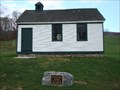
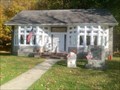
in First of its Kind This former school is the location where the first American woman cast a vote in a national election in 1920. It is also believed to be the oldest one-room schoolhouse in the United States. posted by:  Marine Biologist Marine Biologist location: Massachusetts date approved: 11/05/2010 last visited: 10/08/2013 |
| view gallery E3.9 km |  New Ashford Schoolhouse - New Ashford, MA New Ashford Schoolhouse - New Ashford, MA
in Former Schools This former school is believed to be the oldest one-room schoolhouse in the United States. It is also the location where the first American woman cast a vote in a national election in 1920 posted by: Marine Biologist location: Massachusetts date approved: 11/06/2010 last visited: 10/08/2013 |
| view gallery E3.9 km |  New Ashford Schoolhouse - New Ashford, MA New Ashford Schoolhouse - New Ashford, MA
in One-Room Schoolhouses This former school is believed to be the oldest one-room schoolhouse in the United States. It is also the location where the first American woman cast a vote in a national election in 1920 posted by: Marine Biologist location: Massachusetts date approved: 11/06/2010 last visited: 10/08/2013 |
 view gallery view galleryE3.9 km |  New Ashford Town Hall Playground - New Ashford, MA New Ashford Town Hall Playground - New Ashford, MA
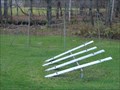
in Public Playgrounds A small playground is located on the grounds of the New Ashford Town Hall in New Ashford, Massachusetts, USA. posted by: Marine Biologist location: Massachusetts date approved: 11/09/2010 last visited: 10/06/2013 |
 view gallery view galleryE3.9 km |  New Ashford, Massachusetts New Ashford, Massachusetts
in Wikipedia Entries The town of New Ashford is located in Berkshire County, Massachusetts, USA. The posted coordinates are for the New Ashford Town Hall. posted by: Marine Biologist location: Massachusetts date approved: 11/05/2010 last visited: 10/06/2013 |
 view gallery view galleryE3.9 km |  New Ashford, Massachusetts, USA New Ashford, Massachusetts, USA
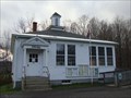
in City and Town Halls The New Ashford Town Hall is a small, single-story, white wooden building. posted by: Marine Biologist location: Massachusetts date approved: 11/06/2010 last visited: 10/06/2013 |
 view gallery view gallery SE4 km SE4 km
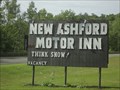
|  New Ashford Motor Inn - New Ashford, MA New Ashford Motor Inn - New Ashford, MA
in Recommended Accommodation a motel located in New Ashford, MA posted by: oiseau_ca location: Massachusetts date approved: 07/24/2016 last visited: never |
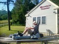
 view gallery view gallerySE4.2 km |  The Springs - New Ashford, MA The Springs - New Ashford, MA
in Neon Signs The Springs Inn & Resort in New Ashford, Massachusetts, USA, has a neon sign. posted by: Marine Biologist location: Massachusetts date approved: 11/06/2010 last visited: 10/05/2013 |
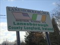 view gallery view gallerySE5.6 km |  Sister City Sign - Lanesborough, MA Sister City Sign - Lanesborough, MA
in Sister City Monuments A sign proudly proclaiming the sister city relationship between Lanesborough, Massachusetts, USA, and Lanesborough, County Longford, Ireland. posted by: Marine Biologist location: Massachusetts date approved: 11/06/2010 last visited: 07/05/2019 |
 view gallery view gallery S6.6 km S6.6 km
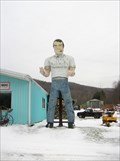
|  The Berkshire Giant The Berkshire Giant
in Highway Giants - Muffler Men The only "Muffler" Man in Berkshire County and possibly Western Massachusetts. posted by: genegene location: Massachusetts date approved: 01/01/2010 last visited: 03/20/2023 |
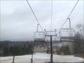 view gallery view galleryS6.9 km |  Jiminy Peak - Hancock, Massachusetts Jiminy Peak - Hancock, Massachusetts
in Winter Sports Locations Take Corey Road south off of Brodie Mountain Road. posted by: elyob location: Massachusetts date approved: 04/27/2019 last visited: 08/06/2021 |
 view gallery view galleryS6.9 km |  Jiminy Peak Mountain Coaster - Hancock, Massachusetts Jiminy Peak Mountain Coaster - Hancock, Massachusetts
in Bobsleigh Chutes and Mountain Slides 37 Corey Road, Hancock, Massachusetts posted by: elyob location: Massachusetts date approved: 07/10/2019 last visited: never |
 view gallery view galleryS8.9 km |  Taylor Memorial Library, Hancock, Massachusetts Taylor Memorial Library, Hancock, Massachusetts
in Libraries The library is at 155 Main Street. posted by: elyob location: Massachusetts date approved: 10/15/2019 last visited: never |
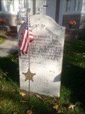 view gallery view galleryS8.9 km |  War of the Rebellion Tablet - Hancock, MA War of the Rebellion Tablet - Hancock, MA
in American Civil War Monuments and Memorials The marker is at 155 Main Street, Hancock, Massachusetts. posted by: elyob location: Massachusetts date approved: 10/15/2019 last visited: never |
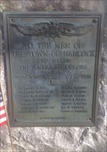 view gallery view galleryS8.9 km |  World War Memorial, Hancock, Massachusetts World War Memorial, Hancock, Massachusetts
in World War I Memorials and Monuments There are other war memorials nearby. posted by: elyob location: Massachusetts date approved: 10/16/2019 last visited: never |
 view gallery view galleryS8.9 km |  Korean War Memorial - Hancock Honor Roll - Hancock, MA Korean War Memorial - Hancock Honor Roll - Hancock, MA
in Korean War Memorials 155 Main Street posted by: elyob location: Massachusetts date approved: 10/22/2019 last visited: never |
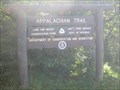 view gallery view galleryE8.9 km |  Appalacian Trail - Sign on Mount Greylock, MA Appalacian Trail - Sign on Mount Greylock, MA
in Appalachian Trail Located at the roadside near the summit of Mount Greylock, along the AT corridor. posted by: The Blue Quasar location: Massachusetts date approved: 09/25/2008 last visited: 09/23/2008 |
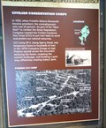 view gallery view gallerySE9.2 km |  CCC Camp SP-7 - Lanesborough, MA CCC Camp SP-7 - Lanesborough, MA
in Civilian Conservation Corps This CCC information board is located inside the Mount Greylock State Reservation Visitor Center in Lanesborough, MA. posted by:  denben denben location: Massachusetts date approved: 09/17/2014 last visited: 05/29/2022 |
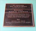 view gallery view gallerySE9.2 km |  Mt. Greylock Old Growth Spruce - Adams, Ma Mt. Greylock Old Growth Spruce - Adams, Ma
in U.S. National Natural Landmarks Because of its extensive stands of red spruce old growth, The Hopper - a cirque located on the west side of Mount Greylock - has been designated a National Natural Landmark since 1987. posted by: denben location: Massachusetts date approved: 10/13/2014 last visited: 08/01/2012 |
 view gallery view gallerySE9.2 km |  Mount Greylock State Reservation Visitor Center - Lanesborough, MA Mount Greylock State Reservation Visitor Center - Lanesborough, MA
in Ranger Stations Visitor services, orientation and recreational information for Mount Greylock State Reservation and Massachusetts State Parks in the Berkshire region. posted by: denben location: Massachusetts date approved: 09/17/2014 last visited: 05/29/2022 |
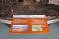
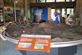 view gallery view gallerySE9.2 km |  Mount Greylock State Reservation Map Model - Lanesborough, MA Mount Greylock State Reservation Map Model - Lanesborough, MA
in 3D Map Models of Our World and Beyond This 3D Map model is located inside the Mount Greylock State Reservation Visitor Center in Lanesborough, MA. posted by: denben location: Massachusetts date approved: 09/17/2014 last visited: 08/01/2012 |
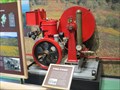 view gallery view gallerySE9.2 km |  1927 Fitzhenry Guptill Fire Pump - Lanesborough, MA 1927 Fitzhenry Guptill Fire Pump - Lanesborough, MA
in Preserved Machines on Public Display This Fire Pump is located inside the Mount Greylock State Reservation Visitor Center in Lanesborough, MA. posted by: denben location: Massachusetts date approved: 09/17/2014 last visited: 05/29/2022 |
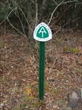 view gallery view galleryE9.5 km | AT Sign near the Gould Trail Parking Area - Mount Greylock State Reservation, MA in Appalachian Trail This Appalachian Trail sign is located at the intersection of Rockwell Road and North Adams Road near the Gould Trail Parking Area in the Mount Greylock State Reservation in Massachusetts. posted by: Marine Biologist location: Massachusetts date approved: 11/08/2010 last visited: 08/11/2014 |
 view gallery view gallerySE9.5 km |  The Rockwell Road to Greylock The Rockwell Road to Greylock
in Massachusetts Historical Markers This historical marker about the Rockwell Road to Greylock is located at the beginning of the road that winds its way up to Mount Greylock, the highest point in Massachusetts at 3,491 feet above sea level. posted by: Marine Biologist location: Massachusetts date approved: 11/21/2010 last visited: 05/26/2022 |
 view gallery view gallery SW9.8 km SW9.8 km
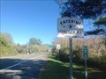
|  MA/NY on state 43 MA/NY on state 43
in Border Crossings This highway is known as route 43 in both Massachusetts and New York. posted by: elyob location: Massachusetts date approved: 10/20/2018 last visited: never |
|