 view gallery view gallery N12.4 km N12.4 km
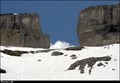
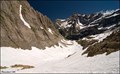
|   La Brèche de Roland - Pyrenees Mts. (France) La Brèche de Roland - Pyrenees Mts. (France)
in Wikipedia Entries La Brèche de Roland is a natural gap, 40 m wide and 100 m high at an elevation of 2804 m, located in the Pyrenees Mts. on the border of Aragón, northern Spain and Hautes-Pyrénées, France. posted by:  Dorcadion Team Dorcadion Team location: Occitanie, France date approved: 08/20/2014 last visited: 08/01/2019 |
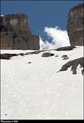 view gallery view galleryN12.4 km |  La Brèche de Roland / Roland's Gap - Pyrenees Mts. (France) La Brèche de Roland / Roland's Gap - Pyrenees Mts. (France)
in Named Mountain Gaps La Brèche de Roland (Roland's Gap) is a natural mountain gap, 40 m wide and 100 m high at an elevation of 2804 m, located in the Pyrenees Mts. on the French-Spanish borders. posted by: Dorcadion Team location: Occitanie, France date approved: 08/21/2014 last visited: 06/05/2022 |
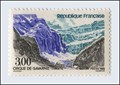
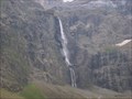
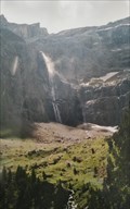
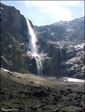 view gallery view galleryN12.6 km |  Le Grande Cascade de Gavarnie / The Gavarnie Falls (Hautes-Pyrénées, France) Le Grande Cascade de Gavarnie / The Gavarnie Falls (Hautes-Pyrénées, France)
in Waterfalls Le Grande Cascade de Gavarnie (The Gavarnie Falls) is a tiered waterfall and with overall drop of 422 m is the tallest waterfall in France. The falls are situated in Cirque de Gavarnie, close to the village Gavarnie in the Pyrénées Mts. posted by: Dorcadion Team location: Occitanie, France date approved: 05/04/2009 last visited: 08/28/2022 |
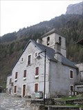
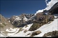 view gallery view galleryN12.9 km |  Refuge des Sarradets - Pyrenees Mts. (France) Refuge des Sarradets - Pyrenees Mts. (France)
in Remote Backcountry Shelters Depicted chalet "Refuge des Sarradets" is mountain refuge (altitude 2 587 m) located in the heart of Pyrénées National Park, close to the stunning Cirque Gavarnie and under mythic Brèche de Roland at French-Spanish border... posted by: Dorcadion Team location: Occitanie, France date approved: 08/21/2014 last visited: 06/05/2022 |
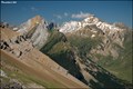
 view gallery view galleryN13.2 km |  Pyrénées - Mont Perdu (France) Pyrénées - Mont Perdu (France)
in World Heritage Sites Stunning mountain landscape, which spans the contemporary national borders of France and Spain, centered around the peak of Mt. Perdu is one from the jewels of Nature in the European context... posted by: Dorcadion Team location: Occitanie, France date approved: 05/28/2009 last visited: 04/29/2012 |
 view gallery view galleryN13.4 km |  Cirque de Gavarnie (France) Cirque de Gavarnie (France)
in Philatelic Photographs This French stamp depicts the most impressive natural amphitheatre in Europe - Cirque de Gavarnie in the Pyrenees National Park. posted by: Dorcadion Team location: Occitanie, France date approved: 03/25/2010 last visited: 08/28/2022 |
 view gallery view galleryN13.5 km |  Cirque de Gavarnie - France Cirque de Gavarnie - France
in Glaciers Cirque de Gavarnie posted by: lulu_et_compagnie location: Occitanie, France date approved: 11/25/2018 last visited: 08/28/2022 |
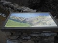
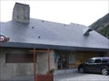
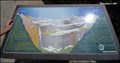 view gallery view galleryN13.7 km |  Cirque de Gavarnie Orientation Panel (Pyrenees Mts., France) Cirque de Gavarnie Orientation Panel (Pyrenees Mts., France)
in Orientation Tables Close to the entrance to the magnificent Cirque de Gavarnie (Cirque is amphitheatre-like valley) in Pyrenees Mts. you can find the orientation panel depicting and describing the Cirque... posted by: Dorcadion Team location: Occitanie, France date approved: 09/09/2009 last visited: 08/28/2022 |
 view gallery view galleryN13.7 km | la table d'orientation du cirque de Gavarnie - Midi-Pyrénées, France in Orientation Tables En faisait la randonnée pour aller voir le cirque de Gavarnie, vous pourrez voir cette table d'orientation, juste à côté du café restaurant hôtel du cirque et de la cascade. posted by: Emeraude37 location: Occitanie, France date approved: 02/23/2016 last visited: 08/28/2022 |
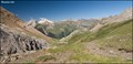 view gallery view galleryN14.3 km |  Ara Valley from Puerto de Bujaruelo (Pyrennes Mts., Spain) Ara Valley from Puerto de Bujaruelo (Pyrennes Mts., Spain)
in Scenic Overlooks Beautiful vista over Ara valley in Aragonian part of Pyrenees Mts. you can find couple meters from French-Spain borders, in mountain pass called Puerto de Bujaruelo... posted by: Dorcadion Team location: Aragón, Spain date approved: 09/09/2009 last visited: 03/06/2014 |
 view gallery view galleryN15.1 km | Col de Tentes - Refuge des Sarradets (Pyrennes Mts., France) in Scenic Hikes Short, but magnificent vistas offering trail from parking at Col de Tentes (2200 m) to Refuge des Sarradets (2600 m) in Pyrennes Mountains, is a perfect 1/2 day program for any mountains lover... posted by: Dorcadion Team location: Occitanie, France date approved: 06/26/2009 last visited: 08/01/2019 |
 view gallery view galleryN16.3 km | Gavarnie Cirque. Pyrénées - Mont Perdu (France, Spain) ID:113384 in World Heritage Sites FR - Gavarnie (Gavarnia en occitan gascon) est une ancienne commune française. posted by: geotrouvtou59 location: Occitanie, France date approved: 04/30/2021 last visited: 08/28/2022 |
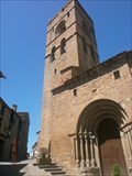
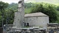
 view gallery view galleryN16.7 km | Chemins de Saint-Jacques-de-Compostelle en France - église paroissiale Saint-Jean-Baptiste, Gavarnie (Haute Pyrénées) ID=868-057 in World Heritage Sites [FR] L’église est située en arrivant au village, sur la droite, le long de l’ancienne route de Saint-Jacques-de-Compostelle. [EN] The church is situated to the right as one approaches the village, along the former route of Santiago de Compostella. posted by: RakeInTheCache location: Occitanie, France date approved: 05/23/2012 last visited: 08/01/2019 |
 view gallery view galleryN16.9 km |  Parc national des Pyrénées - France Parc national des Pyrénées - France
in National Parks of the World [FR] Le Parc national des Pyrénées est l'un des dix Parcs nationaux de France. [EN] The Pyrénées National Park is located within the French départements of Hautes-Pyrénées and Pyrénées-Atlantiques. posted by: RakeInTheCache location: Occitanie, France date approved: 05/26/2012 last visited: 08/28/2022 |
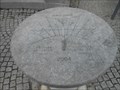 view gallery view galleryN17.1 km |  le cadran solaire de Gavarnie. le cadran solaire de Gavarnie.
in Sundials devant l'office du tourisme de Gavarnie, il y a ce cadran solaire. posted by: Emeraude37 location: Occitanie, France date approved: 03/21/2016 last visited: 08/01/2019 |
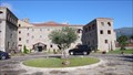 view gallery view gallery SE17.7 km SE17.7 km
|  Barceló Monasterio de Boltaña, Boltana, Huesca, Spain Barceló Monasterio de Boltaña, Boltana, Huesca, Spain
in Antique Hotels A wonderful hotel to relax and a fine spot to explore the surroundings. posted by: g300td location: Aragón, Spain date approved: 01/16/2015 last visited: never |
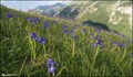 view gallery view galleryN18.2 km |  Iris meadows at Gavarnie (Pyrénées Mts., France) Iris meadows at Gavarnie (Pyrénées Mts., France)
in Flower Fields Alpine meadows covered by countless Iris flowers you can visit every summer above village Gavarnie, in the centre of Pyrénées mountains in South West of France. posted by: Dorcadion Team location: Occitanie, France date approved: 06/23/2009 last visited: 08/01/2019 |
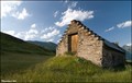 view gallery view galleryN19.8 km |  Traditional Hay-Barns above Gavarnie (Pyrenees Mts., France) Traditional Hay-Barns above Gavarnie (Pyrenees Mts., France)
in Barns On beautiful alpine meadows above Gavarnie village you can find several typical farms which have remote hay-barns built from stone. This is one of them... posted by: Dorcadion Team location: Occitanie, France date approved: 06/26/2009 last visited: 08/01/2019 |
 view gallery view gallerySE21.9 km |  Iglesia-colegiata de la Asunción de Nuestra Señora. Ainsa. Spain Iglesia-colegiata de la Asunción de Nuestra Señora. Ainsa. Spain
in Spanish Heritage Iglesia-colegiata de la Asunción de Nuestra Señora posted by: lulu_et_compagnie location: Aragón, Spain date approved: 09/15/2015 last visited: 11/29/2022 |
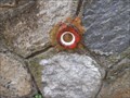 view gallery view galleryN23 km |  le pont au-dessus du Gave - Gèdre, Midi-Pyrénées, France le pont au-dessus du Gave - Gèdre, Midi-Pyrénées, France
in French Benchmarks Sur le pont de Gèdre qui passe au dessus du Gave, il y a un point géodésique. posted by: Emeraude37 location: Occitanie, France date approved: 02/19/2016 last visited: 08/01/2019 |
 view gallery view gallery NE27.8 km NE27.8 km
|  la chapelle des templiers, Aragnouet, France la chapelle des templiers, Aragnouet, France
in Legacy of Medieval Spiritual Warriors La chapelle des templiers d'Aragnouet - The chapel of the Templars of Aragnouet posted by: celene37 location: Occitanie, France date approved: 02/23/2018 last visited: 02/23/2018 |
 view gallery view gallery W29.9 km W29.9 km
|  Navasa Navasa
in Bicycle Shops En el centro de Sabiñánigo posted by: >fetiche< location: Aragón, Spain date approved: 09/07/2006 last visited: never |
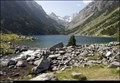 view gallery view galleryN30.1 km |  Lac de Gaube / Gaube Lake - Pyrenees (France) Lac de Gaube / Gaube Lake - Pyrenees (France)
in Natural Lakes Small glacial Lac de Gaube (Gaube Lake), located close to the Pont d’Espagne in Pyrenees Mts., belongs among the most pictoresques lakes of the Pyrenees National Park... posted by: Dorcadion Team location: Occitanie, France date approved: 08/25/2014 last visited: 09/09/2023 |
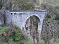
 view gallery view galleryN30.9 km |  Pont Napoléon - Luz-Saint-Sauveur (Haute Pyrénées), France Pont Napoléon - Luz-Saint-Sauveur (Haute Pyrénées), France
in La Famille Bonaparte [FR] Le pont Napoléon est un pont situé près de Luz-Saint-Sauveur, et qui enjambe la Vallée du Gave de Gavarnie. [EN] The Napoleon bridge is situated near the town of Luz-Saint-Sauveur and crosses the valley of the Gave de Gavarnie. posted by: RakeInTheCache location: Occitanie, France date approved: 05/26/2012 last visited: 08/01/2019 |
 view gallery view galleryN30.9 km |  Saut à l'élastique Pont Napoléon - Luz-Saint-Sauveur (Haute Pyrénées), France Saut à l'élastique Pont Napoléon - Luz-Saint-Sauveur (Haute Pyrénées), France
in Bungee Jump Sites [FR] Haut de 90 mètres, il vous garantie des émotions exceptionnelles et une montée d'adrénaline sans pareil. [EN] Through July and August you can go Bungee Jumping on Pont Napoleon. posted by: RakeInTheCache location: Occitanie, France date approved: 05/22/2012 last visited: 08/01/2019 |
|