 view gallery view gallery W1.8 km W1.8 km
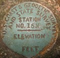
|   15 N 15 N
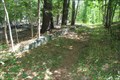
in U.S. Benchmarks A US C&GS and State Survey disk embedded in the top of a stone wall in Milton, MA. posted by:  Shorelander Shorelander location: Massachusetts date approved: 10/04/2006 last visited: 09/30/2006 |
 view gallery view gallery S2.1 km S2.1 km
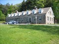
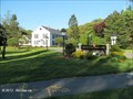
|  Station H-7, State Police Barracks - Milton, MA Station H-7, State Police Barracks - Milton, MA
in Police Stations This beautiful stone wall building within the Blue Hills Reservation, houses the Massachusetts State Police barracks, H-7, which patrols not only the Blue Hills Reservation, but also portions of I-93/Route 128. posted by:  NorStar NorStar location: Massachusetts date approved: 05/21/2009 last visited: never |
 view gallery view gallery NW2.1 km NW2.1 km
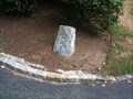
|  Milton/Hyde Park Town Border Marker - Fairmount Ave. Milton/Hyde Park Town Border Marker - Fairmount Ave.
in U.S. Historic Survey Stones and Monuments A granite post marking the town border between Hyde Park, MA (now part of Boston) and Milton, MA on Fairmount Ave. posted by: tdblalock location: Massachusetts date approved: 09/14/2010 last visited: never |
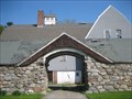
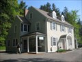 view gallery view galleryS2.1 km |  Blue Hills Reservation, Mass. DCR - Milton-Quincy, MA Blue Hills Reservation, Mass. DCR - Milton-Quincy, MA
in Ranger Stations This building is the headquarters and ranger station for the Blue Hills Reservation, one of the largest undeveloped tracts of woods in the Boston metropolitan area. posted by: NorStar location: Massachusetts date approved: 05/18/2009 last visited: never |
 view gallery view galleryS2.1 km |  Blue Hills Headquarters - Milton, MA Blue Hills Headquarters - Milton, MA
in U.S. National Register of Historic Places The Blue Hills Reservation Headquarters is a house-like structure at one of the many trail heads in the Blue Hills Reservation, and is the central location for the reservation's Department of Conservation and Recreation Rangers. posted by: NorStar location: Massachusetts date approved: 05/21/2009 last visited: never |
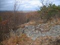 view gallery view galleryS2.1 km |  Skyline Trail - Blue Hill Reservation - Milton-Quincy-Canton, MA Skyline Trail - Blue Hill Reservation - Milton-Quincy-Canton, MA
in Scenic Hikes The Skyline Trail is a trail that extends the length of the Blue Hill Reservation and runs along the peaks of the Blue Hill range, providing views of the surrounding area, including Boston and Boston Harbor. posted by: NorStar location: Massachusetts date approved: 11/04/2009 last visited: 01/17/2016 |
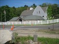
 view gallery view galleryS2.1 km |  Blue Hill Reservation Former Horse Stable - Milton, MA Blue Hill Reservation Former Horse Stable - Milton, MA
in Barns This barn by the Blue Hills Reservation Headquarters on the Milton-Quincy line, was once the stables for horses used for mounted rangers and police in the former Metropolitan District Commission Reservations. posted by: NorStar location: Massachusetts date approved: 05/20/2009 last visited: never |
 view gallery view galleryS2.1 km | Metropolitan District Commission Stable - Milton, MA in U.S. National Register of Historic Places The former Metropolitan District Commission Horse Stables was once the home of the MDC and Massachusetts State Police mounted units, but now appears to be empty and neglected. posted by: NorStar location: Massachusetts date approved: 05/21/2009 last visited: never |
 view gallery view gallery SW2.1 km SW2.1 km
| Boston 10 Miles/Route 138 in U.S. Historic Survey Stones and Monuments A milestone 10 miles from Boston. posted by: Shorelander location: Massachusetts date approved: 10/06/2006 last visited: 10/22/2006 |
 view gallery view galleryS2.1 km | Milton-Quincy Corner Boundary Marker by Hillside Street, Blue Hills Reservation, MA in U.S. Historic Survey Stones and Monuments This stone post marks a corner of the border between Quincy and Milton, Massachusetts, not far from the old state police/MDC horse stables. posted by: NorStar location: Massachusetts date approved: 05/27/2009 last visited: never |
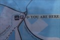 view gallery view galleryW2.3 km |  Yuo Are Here, Burma Road Parking Lot, Neponset River Reservation - Milton, MA Yuo Are Here, Burma Road Parking Lot, Neponset River Reservation - Milton, MA
in 'You Are Here' Maps This kioak at a parking lot for the Neponset River Reservation is at the start of a straight path through beautiful wetlands of the Nesponet River. posted by: NorStar location: Massachusetts date approved: 12/29/2018 last visited: never |
 view gallery view gallery E2.3 km E2.3 km
|  Blue Hills Camp - Blue Hills Reservation - Milton, MA Blue Hills Camp - Blue Hills Reservation - Milton, MA
in Civilian Conservation Corps From 1933 to 1937 the CCC occupied this location and built several structures and trails within the reservation. posted by: NorStar location: Massachusetts date approved: 09/03/2015 last visited: never |
 view gallery view galleryW2.4 km |  Paul's Bridge - Boston-Milton, MA Paul's Bridge - Boston-Milton, MA
in Arch Bridges Paul's Bridge, a stone bridge over the Neponset River is the third bridge at this crossing. posted by: NorStar location: Massachusetts date approved: 07/30/2016 last visited: never |
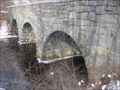 view gallery view galleryW2.4 km |  Paul's Bridge - Boston and Milton, Massachusetts, USA Paul's Bridge - Boston and Milton, Massachusetts, USA
in Stone Bridges Paul's Bridge is a highway bridge that supports a major road connecting Boston with Milton, and, with one reconstruction, has stood since 1849. posted by: NorStar location: Massachusetts date approved: 02/18/2009 last visited: 12/26/2014 |
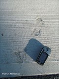 view gallery view gallery NE2.4 km NE2.4 km
|  Child's Footprints in Concrete by Milton Police Station - Milton, MA Child's Footprints in Concrete by Milton Police Station - Milton, MA
in Petrosomatoglyphs This trail of feet is in a new section of concrete in front of the Milon Police Station sign. posted by: NorStar location: Massachusetts date approved: 05/19/2012 last visited: never |
 view gallery view galleryNE2.4 km | Milton Police Department in Police Stations The Milton Police Department is located at the administrative center of town on Highland Avenue and covers the suburban town of Milton. posted by: NorStar location: Massachusetts date approved: 05/27/2012 last visited: never |
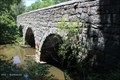 view gallery view galleryW2.4 km | Paul's Bridge - Boston-Milton, MA in U.S. National Register of Historic Places This scenic bridge allows the Neponset River to pass underneath the Neponset River Parkway. posted by: NorStar location: Massachusetts date approved: 07/30/2016 last visited: never |
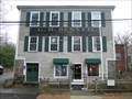 view gallery view galleryNE2.4 km |  G. H. Bent Factory Sign G. H. Bent Factory Sign
in Massachusetts Historical Markers The G. H. Bent Company is known for making the first 'hard tack' biscuit and coined the word 'cracker.' posted by: NorStar location: Massachusetts date approved: 01/25/2007 last visited: never |
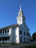 view gallery view galleryNE2.4 km |  The First Parish in Milton, Unitarian-Universalist - Milton, MA The First Parish in Milton, Unitarian-Universalist - Milton, MA
in This Old Church The church, built in 1787 on the west side of the green in Milton is the older of the two clapboard churches, and became the First Parish, Unitarian-Universalist after the split with the Congregational Church in 1834. posted by: NorStar location: Massachusetts date approved: 05/21/2012 last visited: never |
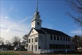 view gallery view galleryNE2.6 km |  First Parish Church - Milton Centre Historic District - Milton, MA First Parish Church - Milton Centre Historic District - Milton, MA
in NRHP Historic Districts - Contributing Buildings The First Parish Church is a two-story rectangular building with gable roof and two-stage tower constructed in 1787-1788. posted by: NorStar location: Massachusetts date approved: 01/06/2019 last visited: never |
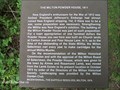 view gallery view galleryNE2.6 km | The Milton Powder House, 1811 - Milton, MA in Massachusetts Historical Markers This powder house was built to prepare for possible hostilities with the British and was brought to this place in 1974 as part of the bicentennial celebrations for the Suffolk Resolves. posted by: NorStar location: Massachusetts date approved: 06/02/2012 last visited: never |
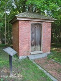 view gallery view galleryNE2.6 km |  Milton Powder House - Milton, MA Milton Powder House - Milton, MA
in War of 1812 The powder house was built in 1811 as part of New England's preparations for possible conflict with the British, which eventually happened at sea and other places but not Milton. posted by: NorStar location: Massachusetts date approved: 05/27/2012 last visited: 08/31/2012 |
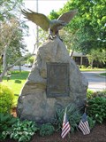 view gallery view galleryNE2.6 km |  Milton Civil War Memorial - Milton, MA Milton Civil War Memorial - Milton, MA
in Smithsonian Art Inventory Sculptures This memorial with an image of an eagle on a rock base is a Civil War memorial that sits on one side of the driveway to the town hall and fire station. posted by: NorStar location: Massachusetts date approved: 05/26/2012 last visited: never |
 view gallery view galleryNE2.6 km |  Civil War Memorial - Milton Center - Milton, MA Civil War Memorial - Milton Center - Milton, MA
in American Civil War Monuments and Memorials This monument with the eagle mounted on top sits between the Milton Common and the First Parish Church. posted by: NorStar location: Massachusetts date approved: 12/31/2018 last visited: never |
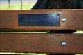 view gallery view galleryNE2.6 km |  Branch Lane - Milton Common - Milton, MA Branch Lane - Milton Common - Milton, MA
in Dedicated Benches This bench is for Branch Lane, who was the assistant DPW Director for Milton. posted by: NorStar location: Massachusetts date approved: 12/30/2018 last visited: never |
|