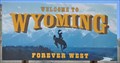
 view gallery view gallery W0.3 km W0.3 km
|   Welcome to Wyoming ~ Forever West Welcome to Wyoming ~ Forever West
in Welcome Signs This Welcome Sign is on the south side of US Highway 30 where is crosses from Idaho into Montana at the very aptly named twon of Border, Wyoming. posted by:  brwhiz brwhiz location: Wyoming date approved: 09/04/2013 last visited: 06/10/2011 |
 view gallery view galleryW0.3 km |  Oregon Trail - Border, WY Oregon Trail - Border, WY
in Wagon Roads and Trails An historical marker near the border of Wyoming and Idaho on Highway 30 commemorating the Oregon Trail that passed this point near Border, Wyoming. posted by:  Chasing Blue Sky Chasing Blue Sky location: Wyoming date approved: 02/23/2012 last visited: 10/04/2021 |
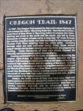 view gallery view galleryW0.3 km |  Oregon Trail 1847 - Border, WY Oregon Trail 1847 - Border, WY
in Wyoming Historical Markers An historical marker near the border of Wyoming and Idaho on Highway 30 commemorating the Oregon Trail that passed this point near Border, Wyoming. posted by: Chasing Blue Sky location: Wyoming date approved: 03/27/2012 last visited: 09/30/2019 |
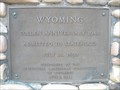 view gallery view galleryW0.3 km | Wyoming - Golden Anniversary 1940 - Wyoming, USA in Wyoming Historical Markers An historical marker along Highway 30, at the border of Idaho and Wyoming, commemorating the 50 years of Wyoming statehood. posted by: Chasing Blue Sky location: Wyoming date approved: 03/19/2012 last visited: 05/25/2020 |
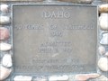
 view gallery view galleryW0.3 km |  Idaho - Fifty Years of Statehood - Idaho, USA Idaho - Fifty Years of Statehood - Idaho, USA
in Idaho Historical Markers An historical marker along Highway 30, at the border of Idaho and Wyoming, commemorating the 50 years of Idaho statehood. posted by: Chasing Blue Sky location: Idaho date approved: 02/23/2012 last visited: 05/25/2020 |
 view gallery view galleryW0.5 km |  Fifty Years of Statehood - Wyoming, USA Fifty Years of Statehood - Wyoming, USA
in Community Commemoration A marker along Highway 30, at the border of Idaho and Wyoming, commemorating the 50 years of Wyoming statehood. posted by: Chasing Blue Sky location: Wyoming date approved: 02/25/2012 last visited: 05/25/2020 |
 view gallery view galleryW0.5 km |  Idaho/ Wyoming - Highway 30 Idaho/ Wyoming - Highway 30
in Border Crossings The Idaho/Wyoming state line on Highway 30. posted by: JacobBarlow location: Wyoming date approved: 10/01/2007 last visited: 05/25/2020 |
 view gallery view galleryW0.5 km | Fifty Years of Statehood - Idaho, USA in Community Commemoration A marker along Highway 30, at the border of Idaho and Wyoming, commemorating the 50 years of Idaho statehood. posted by: Chasing Blue Sky location: Idaho date approved: 02/25/2012 last visited: 05/25/2020 |
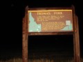 view gallery view galleryW1.9 km | Thomas Fork in Idaho Historical Markers A bad ford gave trouble to wagon trains crossing this stream on
the trail to California and Oregon in 1849. posted by: JacobBarlow location: Idaho date approved: 09/13/2007 last visited: 07/11/2006 |
 view gallery view galleryW5.5 km |  Border Summit - Highway 30 - 6,358 feet Border Summit - Highway 30 - 6,358 feet
in Elevation Signs This elevation sign is located on Highway 30, just west of the Idaho-Wyoming border. posted by: Chasing Blue Sky location: Idaho date approved: 01/19/2012 last visited: 06/10/2011 |
 view gallery view gallery SE15.3 km SE15.3 km
| Cokeville, WY - 6,191 feet in Elevation Signs Cokeville, Wyoming, sits at 6,191 feet in elevation. posted by: Chasing Blue Sky location: Wyoming date approved: 01/19/2012 last visited: 06/10/2011 |
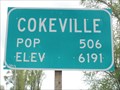
 view gallery view gallerySE15.3 km |  Cokeville, WY - Population 506 Cokeville, WY - Population 506
in Population Signs At 506 residents, Cokeville is the largest town along Highway 30 in western Wyoming. posted by: Chasing Blue Sky location: Wyoming date approved: 01/23/2012 last visited: 06/10/2011 |
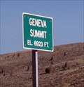 view gallery view gallery NW15.6 km NW15.6 km
| Geneva, Idaho- Elevation 6,923 in Elevation Signs This is the summit near Geneva, Idaho. posted by: Queens Blessing location: Idaho date approved: 11/10/2012 last visited: 09/02/2013 |
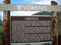 view gallery view gallerySE15.8 km | Cokeville - Cokeville, WY in Wyoming Historical Markers In 1918, Cokeville, Wyoming, was informally know as "Sheep Capital of the World", but today it's slogan is, "Welcome to the Open Range!" posted by: Chasing Blue Sky location: Wyoming date approved: 01/25/2012 last visited: 06/10/2011 |
 view gallery view gallerySE15.8 km |  Cokeville City Park Playground Cokeville City Park Playground
in Public Playgrounds This Public Playground is in the city park located on the south side of Main Street between 2nd Street and Front Street in Cokeville, Wyoming. posted by: brwhiz location: Wyoming date approved: 08/30/2013 last visited: never |
 view gallery view gallerySE15.8 km |  Cokeville , Wyoming 83114 Cokeville , Wyoming 83114
in U.S. Post Offices Here is Cokeville, Wyoming's Post Office! posted by: JacobBarlow location: Wyoming date approved: 09/13/2007 last visited: 09/13/2007 |
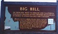 view gallery view galleryW15.9 km | Big Hill in Idaho Historical Markers Said to be the greatest impediment on the whole route. posted by: muddawber location: Idaho date approved: 09/23/2007 last visited: 05/25/2020 |
 view gallery view galleryW15.9 km | The McAuley Cutoff - Dingle, ID in Idaho Historical Markers The McAuley Cutoff, south of Montpelier, Idaho, created a more passable road around Big Hill, considered to be the "greatest impediment" along the Oregon Trail. posted by: Chasing Blue Sky location: Idaho date approved: 01/25/2012 last visited: 05/25/2020 |
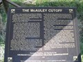 view gallery view galleryW15.9 km | The McAuley Cutoff - Oregon Trail - Dingle, ID in Wagon Roads and Trails The McAuley Cutoff, south of Montpelier, Idaho, created a more passable road around Big Hill, considered to be the "greatest impediment" along the Oregon Trail. posted by: Chasing Blue Sky location: Idaho date approved: 01/19/2012 last visited: 05/25/2020 |
 view gallery view galleryW15.9 km |  The McAuley Cutoff - Oregon Trail - Dingle, ID, USA The McAuley Cutoff - Oregon Trail - Dingle, ID, USA
in Human Migration Monuments The McAuley Cutoff, south of Montpelier, Idaho, created a more passable road around Big Hill, considered to be the "greatest impediment" along the Oregon Trail. posted by: Chasing Blue Sky location: Idaho date approved: 01/30/2013 last visited: 07/11/2006 |
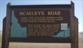 view gallery view galleryW15.9 km | Mcauley's Road in Idaho Historical Markers A road built to circumvent one of the Oregon Trails worst descents. posted by: muddawber location: Idaho date approved: 09/23/2007 last visited: 07/11/2006 |
 view gallery view gallery N16.3 km N16.3 km
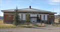
|  Geneva Public School ~ Geneva, Idaho Geneva Public School ~ Geneva, Idaho
in Former Schools This former public school is located on the southwest corner of Center Lane and US Highway 89 in Geneva, Idaho. posted by: brwhiz location: Idaho date approved: 11/11/2012 last visited: never |
 view gallery view galleryN16.3 km |  District 33 Public School ~ Geneva, Idaho District 33 Public School ~ Geneva, Idaho
in Dated Buildings and Cornerstones This former public school, built in 1930, is located on the southwest corner of Center Lane and US Highway 89 in Geneva, Idaho. posted by: brwhiz location: Idaho date approved: 11/14/2012 last visited: never |
 view gallery view gallerySE16.3 km | Old Oregon Trail - Cokeville, WY in Wyoming Historical Markers An historical marker on Highway 30 in Cokeville, Wyoming, commemorating the Oregon Trail that passed this location. posted by: Chasing Blue Sky location: Wyoming date approved: 03/27/2012 last visited: 06/10/2011 |
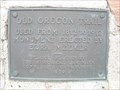 view gallery view gallerySE16.3 km | Old Oregon Trail - Cokeville, WY in Wagon Roads and Trails An historical marker on Highway 30 in Cokeville, Wyoming, commemorating the Oregon Trail that passed this location. posted by: Chasing Blue Sky location: Wyoming date approved: 02/23/2012 last visited: 06/10/2011 |
|