 view gallery view gallery E2.6 km E2.6 km
|   Massachusetts - Northeast Corner of Connecticut Massachusetts - Northeast Corner of Connecticut
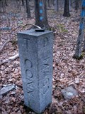
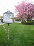
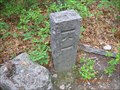
in U.S. Historic Survey Stones and Monuments This marker of the northeast corner of Connecticut can be reached by following blue dots from High Street straight north for about 1/8 mile into the woods. posted by:  NorStar NorStar location: Connecticut date approved: 05/08/2010 last visited: 05/15/2011 |
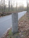 view gallery view galleryE2.6 km | MA-CT Eastern Border at High Street in U.S. Historic Survey Stones and Monuments This stone survey marker is along the short eastern border between (Douglas) Massachusetts and (Thompson) Connecticut, on High Street, which nicks the corner of Connecticut. posted by: NorStar location: Massachusetts date approved: 05/08/2010 last visited: 08/19/2015 |
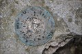
 view gallery view gallery NE2.7 km NE2.7 km
|  NGS PID# 3721 - WOOD HILL NGS PID# 3721 - WOOD HILL
in U.S. Benchmarks NGS PID# 3721 - WOOD HILL posted by:  Ganuman Ganuman location: Massachusetts date approved: 09/21/2011 last visited: never |
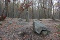
 view gallery view gallery SE2.7 km SE2.7 km
|  Site Of The Great East Thompson Train Wreck Site Of The Great East Thompson Train Wreck
in Railway Disaster Sites The location of the only four train wreck in U.S. history. posted by: dremoto location: Massachusetts date approved: 09/29/2008 last visited: 11/18/2017 |
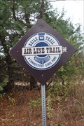 view gallery view gallerySE2.9 km |  Airline Rail Trail, East Thompson Road Access - Thompson, CT Airline Rail Trail, East Thompson Road Access - Thompson, CT
in Rails to Trails Near where the Airline State Park Trail crosses East Thompson Road was the site of the nation's only four train collision. posted by: NorStar location: Connecticut date approved: 03/15/2018 last visited: 08/07/2021 |
 view gallery view gallerySE2.9 km |  Airline Trail State Park, East Thompson Access - Connecticut, Thompson Airline Trail State Park, East Thompson Access - Connecticut, Thompson
in State/Provincial Parks The Airline Trail State Park is a narrow ribbon of protected space along an old railroad right of way posted by: NorStar location: Connecticut date approved: 02/25/2018 last visited: never |
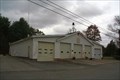 view gallery view gallerySE2.9 km |  East Thompson Volunteer Fire Dept. Station 85, Thompson, CT East Thompson Volunteer Fire Dept. Station 85, Thompson, CT
in Firehouses Small volunteer fire station in the quiet area of East Thompson. posted by: dremoto location: Connecticut date approved: 10/26/2008 last visited: 10/24/2010 |
 view gallery view gallery N2.9 km N2.9 km
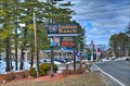
|  Indian Ranch Camp Ground & RV Resort - Indian Ranch Camp Ground & RV Resort -
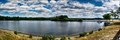
in Campgrounds Located on Lake Chargoggagoggmanchauggagaugchaubunagungamaugg posted by: nomadwillie location: Massachusetts date approved: 09/02/2013 last visited: never |
 view gallery view gallerySE3.1 km | MA-CT Border in U.S. Historic Survey Stones and Monuments This monument marks the Massachusetts-Connecticut border where it crosses the Southern New England Trunk Line Trail. posted by: STEMARTHON location: Massachusetts date approved: 06/27/2009 last visited: 06/19/2022 |
 view gallery view gallery SW3.4 km SW3.4 km
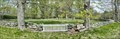
|  Tourtellot Cemetery - North Grosvenor Dale, CT Tourtellot Cemetery - North Grosvenor Dale, CT
in Worldwide Cemeteries Located along Wilsonville Rd near its intersection with Lowell Davis Rd posted by: nomadwillie location: Connecticut date approved: 05/12/2017 last visited: never |
 view gallery view gallery NW3.4 km NW3.4 km
|  Chaubunagungamaug - Webster, MA Chaubunagungamaug - Webster, MA
in Massachusetts Historical Markers Chaubunagungamaug, one of the Praying Indian villages established by Reverend John Eliot, was a community of Nipmuc Indians from about 1674 to around the 1890s. posted by: NorStar location: Massachusetts date approved: 05/06/2010 last visited: 04/17/2016 |
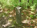
 view gallery view gallerySE3.4 km | Survey Disk TRI STATE, MY3729 - Thompson, CT in U.S. Benchmarks The mark is a a brass disk set close to the ground, southwest of the granite post that marks the corners of Connecticut, Massachusetts, and Rhode Island. posted by: NorStar location: Connecticut date approved: 02/25/2018 last visited: never |
 view gallery view gallerySE3.4 km |  CT-MA-RI - Thompson (CT), Douglas (MA), Burrelville (RI) CT-MA-RI - Thompson (CT), Douglas (MA), Burrelville (RI)
in Tripoints and Multipoints The tri-state boundary marking where Connecticut, Massachusetts, and Rhode Island meet is set in the woods off a rail trail. posted by: NorStar location: Connecticut date approved: 11/26/2017 last visited: 06/19/2022 |
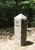 view gallery view gallerySE3.4 km | CT-MA-RI Corner in U.S. Historic Survey Stones and Monuments The location where Connecticut, Rhode Island, and Massachusetts meet. posted by: Shorelander location: Rhode Island date approved: 08/01/2007 last visited: 08/29/2021 |
 view gallery view galleryNW3.5 km |  Beacon Park - Webster MA Beacon Park - Webster MA
in American Guide Series Today the park is not open to the public for access to Webster Lake. There is a pumping station on the grounds owned by the city of Webster. posted by: nomadwillie location: Massachusetts date approved: 10/13/2020 last visited: never |
 view gallery view gallerySE3.5 km | Massachusetts Rhode Island border in U.S. Historic Survey Stones and Monuments Small stone pillar marking the border of MA-RI. posted by: STEMARTHON location: Massachusetts date approved: 06/27/2009 last visited: 11/27/2011 |
 view gallery view galleryNW3.7 km |  Lake Chaubunagungamaug - Webster MA Lake Chaubunagungamaug - Webster MA
in Wikipedia Entries Since 1921, the lake has also been known by a much longer name having 45 letters comprising fourteen syllables: Lake Chargoggagoggmanchauggagoggchaubunagungamaugg. posted by: nomadwillie location: Massachusetts date approved: 10/13/2020 last visited: never |
 view gallery view galleryNW3.7 km | Chargoggagogmanchaugagogchaubunagungamaug - Webster MA in American Guide Series The lake has become famous beyond Central Massachusetts for having the longest name of any geographic feature in all of the United States. posted by: nomadwillie location: Massachusetts date approved: 10/13/2020 last visited: never |
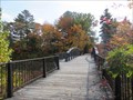 view gallery view galleryNW3.9 km |  North Village Bridge – Webster, MA North Village Bridge – Webster, MA
in Truss Bridges This historic pedestrian truss bridge is located at Memorial Beach Park where it crosses the backwaters of the lake. posted by: wildernessmama location: Massachusetts date approved: 05/14/2017 last visited: never |
 view gallery view galleryNW3.9 km |  May Our Veterans Never Be Forgotten - Webster MA May Our Veterans Never Be Forgotten - Webster MA
in Non-Specific Veteran Memorials Located on the entrance road to Memorial Beach in Webster posted by: nomadwillie location: Massachusetts date approved: 07/05/2016 last visited: never |
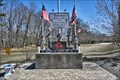 view gallery view galleryNW3.9 km |  World War II Memorial - Webster MA World War II Memorial - Webster MA
in World War II Memorials / Monuments Located at the entrance to Memorial Beach in Webster. posted by: nomadwillie location: Massachusetts date approved: 07/04/2016 last visited: never |
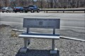 view gallery view galleryNW3.9 km |  May Our Veterans Never Be Forgotten - Webster MA May Our Veterans Never Be Forgotten - Webster MA
in Dedicated Benches Located on the entrance road to Memorial Beach in Webster posted by: nomadwillie location: Massachusetts date approved: 07/04/2016 last visited: never |
 view gallery view gallerySE3.9 km | MA-RI Border in U.S. Historic Survey Stones and Monuments Small stone pillar marking the border of MA-RI. posted by: STEMARTHON location: Massachusetts date approved: 06/27/2009 last visited: 11/27/2011 |
 view gallery view galleryNW3.9 km |  LONGEST Named Thing in America - Webster MA LONGEST Named Thing in America - Webster MA
in Superlatives Lake Chargoggagoggmanchauggagoggchaubunagungamaugg is located in Webster MA posted by: nomadwillie location: Massachusetts date approved: 07/05/2016 last visited: 11/21/2016 |
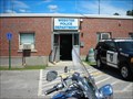 view gallery view galleryNW4 km |  Webster Police Dept - Webster MA Webster Police Dept - Webster MA
in Police Stations The Webster Police Dept is located on Thompson Rd posted by: nomadwillie location: Massachusetts date approved: 01/02/2009 last visited: 01/02/2009 |
|