 view gallery view gallery N4.7 km N4.7 km
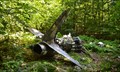
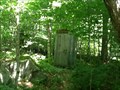
|   Van Wyck Mountain T-33 Crash Site Van Wyck Mountain T-33 Crash Site
in Plane Crash Sites The wreckage of a T-33 military trainer on the southern ridge of Van Wyck mountain in the Catskills. posted by:  M.Bahlam M.Bahlam location: New York date approved: 01/03/2015 last visited: never |
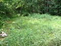
 view gallery view galleryN7.9 km |  Dennning Rd DEC primitive campsite Dennning Rd DEC primitive campsite
in Free Campsites This site just off Denning Road has direct access to the East Branch Neversink River. posted by:  sagefemme sagefemme location: New York date approved: 08/20/2014 last visited: never |
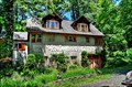
 view gallery view gallery SW8.5 km SW8.5 km
|  NYC DEP Police 5th Pct. NYC DEP Police 5th Pct.
in Police Stations This building stations the 5th Pct of the NYC Department of Environmental Protection Police.
posted by: POCrow222 location: New York date approved: 12/08/2007 last visited: 12/08/2007 |
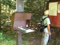
 view gallery view galleryN10 km |  Eastern Terminus - Finger Lakes Trail - New York Eastern Terminus - Finger Lakes Trail - New York
in Long Distance Hiking Trails This is a very significant coordinate for those who are attempting to earn credit for End-to-end status on the Finger Lakes Trails, as it is the easternmost end, and the hardest to get to, much less hike. posted by: sagefemme location: New York date approved: 08/20/2014 last visited: never |
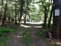
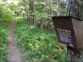
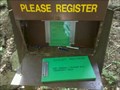
 view gallery view galleryN10.6 km | Phonicia-East Branch Trailhead - Denning, NY in Trail Registers The first 1.2 miles of this trail is also the last 1.2 miles of the Finger Lakes Trail. At that point it intersects with the Peekamoose-Table Trail. The Phonicia-East Branch Trail continues to the left and intersects with Curtis-Ormsbee Trail. posted by: sagefemme location: New York date approved: 09/01/2014 last visited: never |
 view gallery view galleryN10.6 km |  Phonicia-East Branch (Denning) Trail - Catskills, NY Phonicia-East Branch (Denning) Trail - Catskills, NY
in Hiking and walking trailheads See notes on trail register waymark... This trail ultimately, can take you far. posted by: sagefemme location: New York date approved: 08/24/2014 last visited: never |
 view gallery view gallery NE13.7 km NE13.7 km
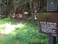
|  Highest Point in Ulster County (New York State) Highest Point in Ulster County (New York State)
in Geographic High Points Slide Mountain is the highest point in Ulster County. posted by: weathernowcast location: New York date approved: 07/15/2010 last visited: 12/03/2016 |
 view gallery view gallery NW15 km NW15 km
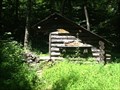
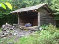
|  Fall Brook Leanto - Catskills, NY Fall Brook Leanto - Catskills, NY
in Remote Backcountry Shelters This Leanto site felt rather cramped because the burdock and stinging nettle were encroaching on the firepit, which was very close to the shelter opening. Right on the FLT between Balsam Lake Mountain DEC. Parking and Wild Meadow parking. posted by: sagefemme location: New York date approved: 08/21/2014 last visited: never |
 view gallery view galleryNW15 km |  Fall Brook Shelter outhouse - Catskills, NY Fall Brook Shelter outhouse - Catskills, NY
in Outhouses This one-holer is designed to support through-hikers on the Finger Lakes Trail (FLT) or anyone else seeking to overnight in the back-woods. posted by: sagefemme location: New York date approved: 08/21/2014 last visited: never |
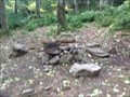
 view gallery view galleryNW16.3 km | Fall Brook bivouac site - Catskills, NY in Free Campsites Somewhat overgrown, I walked past this bivouac site the first time through. It is situated on a small natural meadow beside Fall Brook between the Balsam Lake Mountain DEC parking and the Fall Brook Leanto. posted by: sagefemme location: New York date approved: 08/20/2014 last visited: never |
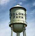 view gallery view gallery SE16.6 km SE16.6 km
|  Colony Farm - Kerhonkson, NY Colony Farm - Kerhonkson, NY
in Named Farms and Ranches Colony Farm is a former state prison dairy farm in the Catskill-Shawangunk Greenway. posted by: nomadwillie location: New York date approved: 04/26/2022 last visited: never |
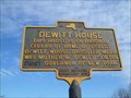 view gallery view gallery S18 km S18 km
|  Dewitt House Dewitt House
in New York Historical Markers Dewitt House NY Historical Marker located on Rt. 209 in Ellenville posted by: Team Smokey location: New York date approved: 04/23/2012 last visited: never |
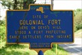 view gallery view gallerySE18.3 km | Site of Colonial Fort in New York Historical Markers Site of Colonial Fort NY Historical Marker located on Route 209 in Kerhonkson posted by: Team Smokey location: New York date approved: 03/04/2008 last visited: 05/13/2009 |
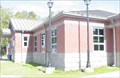
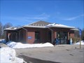 view gallery view gallerySE18.5 km |  Kerhonkson, NY 12446 Kerhonkson, NY 12446
in U.S. Post Offices Kerhonkson, NY 12446 US Post Office posted by: Team Smokey location: New York date approved: 03/08/2008 last visited: 03/19/2009 |
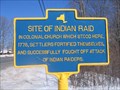 view gallery view gallerySE18.8 km | Site of Indian Raid in New York Historical Markers Site of Indian Raid NY Historical Marker located on Route 209 in Kerhonkson. posted by: Team Smokey location: New York date approved: 03/04/2008 last visited: 05/27/2000 |
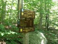
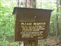 view gallery view galleryNW18.8 km | Wild Meadow Trail (Finger Lakes Trail) - Ulster County, NY in Trail Registers The second of two trails and trail registers at the Balsam Lake DEC parking area. This one heads east past Fall Brook and on to Wild Meadow Wilderness Area. Register is on the woods a litle way... Can't see it from the parking area. posted by: sagefemme location: New York date approved: 09/01/2014 last visited: never |
 view gallery view galleryNW19.2 km | Balsam Lake Mt register - Ulster County, NY in Trail Registers There are two trails and two trail registers at the Balsam Lake DEC parking area. This one goes into the woods on the north end of the parking lot, and keeps going north: destinationBalsam Lake Mountain. posted by: sagefemme location: New York date approved: 09/01/2014 last visited: never |
 view gallery view gallery W20 km W20 km
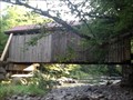
|  Willowemoc Covered Bridge - Sullivan County ,NY Willowemoc Covered Bridge - Sullivan County ,NY
in Covered Bridges This relatively short covered bridge has had extensive work done on it, with new lumber on the sway braces and elsewhere. Located in or off of a private campground, it is closed to through traffic. posted by: sagefemme location: New York date approved: 08/21/2014 last visited: never |
 view gallery view galleryN20 km | Seager / Big Indian Trail - Seager, NY in Trail Registers This trail head is located at the end of Dry Brook Rd in Seager, NY. It has multiple purposes. Some use it for short hikes to nearby falls. Others use it as a start point for a few of the Catskill 3500 peaks. posted by: bhouston21 location: New York date approved: 09/08/2011 last visited: never |
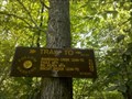 view gallery view galleryN20 km | Seager / Big Indian Trail in Hiking and walking trailheads This trail head is located at the end of Dry Brook Rd in Seager, NY. It has multiple purposes. Some use it for short hikes to nearby falls. Others use it as a start point for a few of the Catskill 3500 peaks. posted by: bhouston21 location: New York date approved: 08/26/2011 last visited: never |
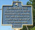 view gallery view galleryS20.1 km | Glassworks Site - Ellenville in New York Historical Markers Site of glassware factory posted by: Vermontish location: New York date approved: 08/23/2008 last visited: 10/31/2019 |
 view gallery view galleryNW20.3 km | Balsam Lake Mountain Leanto - Catskills, NY in Remote Backcountry Shelters This Leanto sits just .1 mile from the trail from Balsam Lake to the summit of Balsam Lake Mountain just below the 3500 foot elevation level. posted by: sagefemme location: New York date approved: 08/21/2014 last visited: never |
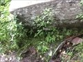 view gallery view galleryNW20.3 km |  Balsam Lake Mountain spring - Catskills, NY Balsam Lake Mountain spring - Catskills, NY
in Natural Springs This is the water source for a Leanto and bivouac site just below the 3500 foot elevation mark on the trail to the summit of Balsam Lake Mountain. posted by: sagefemme location: New York date approved: 08/20/2014 last visited: never |
 view gallery view galleryNW20.3 km | Balsam Lake Mountain bivouac sites - Catskills, NY in Free Campsites The Finger Lakes Trails maps identify the Leanto on Balsam Lake Mountain, but I was surprised to discover a warren of trails all around the Leanto to level patches of ground where tents could be put up as well. posted by: sagefemme location: New York date approved: 08/20/2014 last visited: never |
 view gallery view galleryNE20.4 km |  Brunel, Emile, Studio and Sculpture Garden - Boiceville, NY Brunel, Emile, Studio and Sculpture Garden - Boiceville, NY
in U.S. National Register of Historic Places The Emile Brunel Sculpture Garden and Studio, also known as the Totem Indian Trading Post, Le Chalet Indien, and Brunel Park, is located on Da Silva Road, just off the NY 28 state highway, in Boiceville, Town of Olive, New York, United States. posted by: nomadwillie location: New York date approved: 06/18/2013 last visited: never |
|