 view gallery view gallery SE12.6 km SE12.6 km
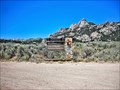
|   Old russian cemetery Old russian cemetery
in Abandoned Cemeteries Old russian cemetery posted by:  saltrunner75 saltrunner75 location: Utah date approved: 05/25/2012 last visited: 11/04/2016 |
 view gallery view gallery E26.9 km E26.9 km
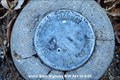
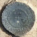
|  Benchmark: MS0615 " WHEELER " Benchmark: MS0615 " WHEELER "
in U.S. Benchmarks This old, historic Benchmark Location is very fun to visit, there is so much history at this old railroad ghost town. posted by: JacobBarlow location: Utah date approved: 12/21/2007 last visited: 10/29/2016 |
 view gallery view gallery NW35.2 km NW35.2 km
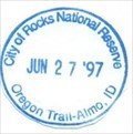
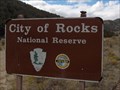
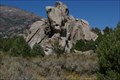
|  City of Rocks National Reserve - Almo, ID City of Rocks National Reserve - Almo, ID
in NPS Passport Cancellation Stations Emigrants of the California Trail describe the rocks here in vivid detail as "a city of tall spires,” “steeple rocks," and "the silent city." Today, this backcountry byway attracts rock climbers, campers, hikers, hunters, and those with the spirit of adventure. posted by:  Don.Morfe Don.Morfe location: Idaho date approved: 02/14/2020 last visited: 12/23/2022 |
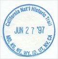 view gallery view galleryNW35.2 km | California National Historic Trail-MO,KS,NE,WY,ID,UT,NV,CA - Almo, ID in NPS Passport Cancellation Stations Follow in the footsteps of over 250,000 emigrants who traveled to the gold fields and rich farmlands of California during the 1840s and 1850s: the greatest mass migration in American history. The California National Historic Trail is over 5,000 miles long and covers portions of 10 states. posted by: Don.Morfe location: Idaho date approved: 02/25/2020 last visited: 12/23/2022 |
 view gallery view galleryNW35.4 km |  City of Rocks National Reserve - Almo ID City of Rocks National Reserve - Almo ID
in Wikipedia Entries The City of Rocks National Reserve, also known as the Silent City of Rocks, is a United States National Reserve and state park in south-central Idaho. It is widely known for its enormous granite rock formations and excellent rock climbing. posted by: Don.Morfe location: Idaho date approved: 04/29/2022 last visited: 12/23/2022 |
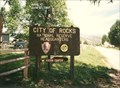 view gallery view galleryNW35.4 km |  City of Rocks National Reserve - Almo ID City of Rocks National Reserve - Almo ID
in Official Local Tourism Attractions The City of Rocks National Reserve, also known as the Silent City of Rocks, is a United States National Reserve and state park in south-central Idaho. It is widely known for its enormous granite rock formations and excellent rock climbing. posted by: Don.Morfe location: Idaho date approved: 04/29/2022 last visited: 12/23/2022 |
 view gallery view galleryNW35.7 km |  Almo, ID 83312 Almo, ID 83312
in U.S. Post Offices Post Office located in Almo, ID posted by: greywolf1242 location: Idaho date approved: 12/07/2006 last visited: never |
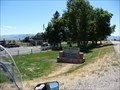
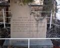 view gallery view galleryNW35.9 km |  Dedicated to the memory of,, Dedicated to the memory of,,
in Idaho Historical Markers Old monument recently uncovered. posted by: muddawber location: Idaho date approved: 10/17/2006 last visited: 10/18/2006 |
 view gallery view galleryNW35.9 km | Idaho State Highway R/W # 41 in U.S. Benchmarks This is an Idaho State Highway Right of Way Marker. posted by: greywolf1242 location: Idaho date approved: 12/07/2006 last visited: never |
 view gallery view galleryNW36 km |  City of Rocks National Reserve City of Rocks National Reserve
in National Parks of the World City of Rocks National Reserve - Almo, Idaho, USA posted by: Chooch72 location: Idaho date approved: 10/07/2007 last visited: 12/23/2022 |
 view gallery view galleryNW36 km | ") City of Rocks National Reserve - Idaho City of Rocks National Reserve - Idaho
in National Parks (U.S.) City of Rocks National Reserve - Almo, Idaho posted by: Chooch72 location: Idaho date approved: 10/08/2007 last visited: 12/23/2022 |
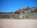 view gallery view galleryNW36 km |  City of Rocks City of Rocks
in Roadside Attractions California Trail wagon trains of the 1840s and 1850s left the Raft River valley and traveled through the area and over Granite Pass into Nevada. posted by: nomadwillie location: Idaho date approved: 09/26/2011 last visited: 12/23/2022 |
 view gallery view galleryNW36 km |  City of Rocks - Almo ID City of Rocks - Almo ID
in U.S. National Register of Historic Places California Trail wagon trains of the 1840s and 1850s left the Raft River valley and traveled through the area and over Granite Pass into Nevada. posted by: nomadwillie location: Idaho date approved: 09/15/2011 last visited: 12/23/2022 |
 view gallery view galleryNW36.4 km |  City of Rocks National Reserve - Almo ID City of Rocks National Reserve - Almo ID
in Wagon Roads and Trails The wagon trains of the 1840 and 1850's traveled thru the area known today as the City of Rocks on the California Trail posted by: nomadwillie location: Idaho date approved: 03/01/2013 last visited: 12/23/2022 |
 view gallery view galleryNW39.8 km |  Castle Rocks State Park - Idaho Castle Rocks State Park - Idaho
in State/Provincial Parks Castle Rock State Park posted by: kJfishman location: Idaho date approved: 01/29/2008 last visited: 10/25/2022 |
 view gallery view gallery NE42.2 km NE42.2 km
| MS0754 ~ ELDER in U.S. Benchmarks This Benchmark is at the junction of Black Pine Road and Utah Highway 30 (Old US Highway 30 South), several miles south of the Utah/Idaho border. posted by: brwhiz location: Utah date approved: 12/15/2013 last visited: never |
 view gallery view galleryNE43 km | MS0262 ~ A 234 in U.S. Benchmarks This Benchmark is on the west side of Black Pine Road about 1.2 miles north of Utah Highway 30 (Old US Highway 30 South) west of Interstate Highway 84 Exit 5, just south of the Utah/Idaho border. posted by: brwhiz location: Utah date approved: 12/15/2013 last visited: never |
 view gallery view galleryNE43.3 km | MS0755 ~ MICROWAVE TWR 1 MI E OF ELDER in U.S. Benchmarks This Benchmark is on the north side of Utah Highway 30 (Old US Highway 30 South) several miles west of the Interstate Highway 84 Exit 5, just south of the Utah/Idaho border. posted by: brwhiz location: Utah date approved: 12/15/2013 last visited: 10/29/2016 |
 view gallery view galleryNE43.8 km |  Utah/Idaho Border on Black Pine Road/3600West Utah/Idaho Border on Black Pine Road/3600West
in Border Crossings This border crossing is on a rural gravel road about seven miles west of Interstate Highway 84. posted by: brwhiz location: Utah date approved: 12/11/2013 last visited: never |
 view gallery view gallery SW43.8 km SW43.8 km
| MS0343 - USCGS Q96 - 1953 - Utah in U.S. Benchmarks U.S. Coast and Geodetic Survey benchmark. posted by: Volcanoguy location: Utah date approved: 12/11/2016 last visited: 09/25/2016 |
 view gallery view galleryE49.4 km | MS0243 ~ FF 89 in U.S. Benchmarks This Benchmark is on the south side of Utah Highway 30 (Old US Highway 30 South) west of Interstate Highway 84 Exit 5, just south of the Utah/Idaho border. posted by: brwhiz location: Utah date approved: 12/15/2013 last visited: never |
 view gallery view galleryNE50.4 km |  Ferruginous Hawk Ferruginous Hawk
in Flora and Fauna Information Signs This Flora and Fauna Sign is located at the Juniper Rest Area at milepost 269 on Interstate Highway 84 just north of the Idaho/Utah border. posted by: brwhiz location: Idaho date approved: 12/07/2012 last visited: 11/06/2022 |
 view gallery view galleryNE50.4 km |  Juniper Eastbound Rest Area Juniper Eastbound Rest Area
in 'You Are Here' Maps You Are Here in the Juniper Eastbound Rest Area located on the southwest side of Interstate Highway 84 at Milepost 229 a few miles north of the Idaho/Utah border. posted by: brwhiz location: Idaho date approved: 02/03/2013 last visited: 10/04/2014 |
 view gallery view galleryNE50.4 km |  Juniper Rest Area ~ Eastbound Juniper Rest Area ~ Eastbound
in Highway Rest Areas The Juniper Rest Area is located on the southwest side of Interstate Highway 84 at Milepost 269 about 47 miles southeast of the junction with Interstate Highway 86. posted by: brwhiz location: Idaho date approved: 02/04/2013 last visited: 07/31/2021 |
 view gallery view galleryNE50.4 km | Lake Bonneville (Southbound Rest Area) in Wikipedia Entries This historical marker about Lake Bonneville is located at the southbound rest area along Interstate 84 in Oneida County, Idaho. posted by: Marine Biologist location: Idaho date approved: 06/03/2008 last visited: 11/06/2022 |
|