 view gallery view gallery SE1.9 km SE1.9 km
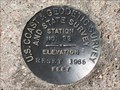
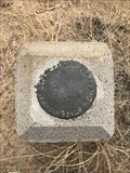
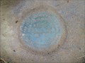
|   92 RESET (MO0703) - Albany County, Wyoming 92 RESET (MO0703) - Albany County, Wyoming
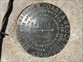
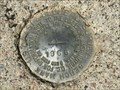
in U.S. Benchmarks This U.S. Coast & Geodetic Survey and State Survey disk is located on the northeast side of U.S. 287/30. posted by:  Tom.dog Tom.dog location: Wyoming date approved: 04/17/2023 last visited: never |
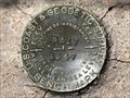
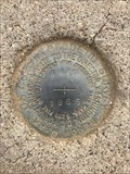
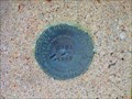
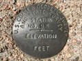 view gallery view gallerySE2.6 km | 93 (MO0701) - Albany County, Wyoming in U.S. Benchmarks A U.S. Coast & Geodetic Survey and State Survey disk to the northeast of U.S. 287/30. posted by: Tom.dog location: Wyoming date approved: 04/17/2023 last visited: never |
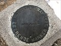
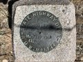 view gallery view gallerySE2.7 km | 7090 73 St. 1287 89.1 - Albany County, Wyoming in U.S. Benchmarks Wyoming State Highway Department Right-of-Way marker on the northeast side of U.S. 287/30. posted by: Tom.dog location: Wyoming date approved: 04/17/2023 last visited: never |
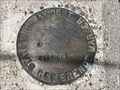
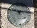 view gallery view gallerySE3.5 km | 7028' 52 St. 1316 + 16 - Albany County, Wyoming in U.S. Benchmarks This Wyoming State Highway Department marker is on the northeast side of U.S. Highway 287/30. posted by: Tom.dog location: Wyoming date approved: 04/17/2023 last visited: never |
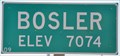 view gallery view gallerySE13 km |  Bosler, Wyoming ~ Elevation 7074 Bosler, Wyoming ~ Elevation 7074
in Elevation Signs This Elevation Sign is at the northern city limits of Bosler, Wyoming on US Highway 30/287. posted by: brwhiz location: Wyoming date approved: 09/25/2012 last visited: 01/04/2018 |
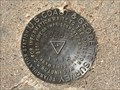 view gallery view gallerySE13.4 km | BOSLER (MO1299) - Albany County, Wyoming in U.S. Benchmarks A triangulation station to the northeast of the small town of Bosler. posted by: Tom.dog location: Wyoming date approved: 04/17/2023 last visited: never |
 view gallery view gallerySE13.4 km | BOSLER NO 1 - Albany County, Wyoming in U.S. Benchmarks Reference mark 1 for triangulation station BOSLER. posted by: Tom.dog location: Wyoming date approved: 04/17/2023 last visited: never |
 view gallery view gallerySE14.6 km | P 317 (MO0691) - Albany County, Wyoming in U.S. Benchmarks A benchmark on the southwest side of U.S. 287/30 to the southeast of the town of Bosler. posted by: Tom.dog location: Wyoming date approved: 04/17/2023 last visited: never |
 view gallery view gallerySE16.4 km | 7059 (MO0760) - Albany County, Wyoming in U.S. Benchmarks A Wyoming State Highway Department reference marker on the southeast side of State Highway 34. posted by: Tom.dog location: Wyoming date approved: 12/09/2022 last visited: never |
 view gallery view gallerySE16.4 km | A 167 (MO0759) - Albany County, Wyoming in U.S. Benchmarks A U.S. Coast & Geodetic Survey benchmark on the southeast side of State Highway 34. posted by: Tom.dog location: Wyoming date approved: 12/09/2022 last visited: never |
 view gallery view gallerySE16.6 km | S 88 (MO0688) - Albany County, Wyoming in U.S. Benchmarks A benchmark disk on the east side of US 30/287. posted by: Tom.dog location: Wyoming date approved: 11/21/2022 last visited: never |
 view gallery view gallery NW16.6 km NW16.6 km
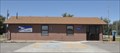
|  Rock River, Wyoming 82083 Rock River, Wyoming 82083
in U.S. Post Offices This Post Office is located at 104 S 5th Street in Rock River, Wyoming. posted by: brwhiz location: Wyoming date approved: 10/31/2011 last visited: never |
 view gallery view gallerySE16.6 km | 7120 (MO0758) - Albany County, Wyoming in U.S. Benchmarks A Wyoming State Highway Department reference marker on the northwest side of State Highway 34. posted by: Tom.dog location: Wyoming date approved: 01/08/2023 last visited: never |
 view gallery view gallerySE17.1 km | 7182 (MO0755) - Albany County, Wyoming in U.S. Benchmarks A State Highway Department reference marker on the northwest side of State Highway 34. posted by: Tom.dog location: Wyoming date approved: 06/25/2023 last visited: never |
 view gallery view gallerySE17.1 km | C 167 (MO0754) - Albany County, Wyoming in U.S. Benchmarks This U.S. Coast & Geodetic Survey benchmark is on the northwest side of State Highway 34. posted by: Tom.dog location: Wyoming date approved: 06/25/2023 last visited: never |
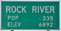 view gallery view galleryNW17.2 km | Rock River, Wyoming ~ Elevation 6892 in Elevation Signs This combination Elevation/Population sign is at the northern city limits of Rock River, Wyoming on US Highway 30/287 (4th Street). posted by: brwhiz location: Wyoming date approved: 09/24/2012 last visited: never |
 view gallery view galleryNW17.2 km |  Rock River, Wyoming ~ Population 235 Rock River, Wyoming ~ Population 235
in Population Signs This combination Elevation/Population sign is at the northern city limits of Rock River, Wyoming on US Highway 30/287 (4th Street). posted by: brwhiz location: Wyoming date approved: 09/25/2012 last visited: never |
 view gallery view gallery S19.3 km S19.3 km
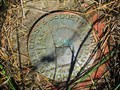
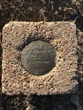
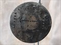
| STATION NO. 64 - Albany County, Wyoming in U.S. Benchmarks A U.S. Coast & Geodetic Survey and State Survey marker on the west side of County Road 51. posted by: Tom.dog location: Wyoming date approved: 10/21/2022 last visited: never |
 view gallery view galleryS20.1 km | STATION NO. 55 - Albany County, Wyoming in U.S. Benchmarks A destroyed U.S. Coast & Geodetic Survey and State Survey marker to the west of County Road 51. posted by: Tom.dog location: Wyoming date approved: 10/21/2022 last visited: never |
 view gallery view galleryNW20.8 km | WILCOX NO 1 - Albany County, Wyoming in U.S. Benchmarks Reference mark 1 for triangulation station Wilcox, located on the west side of US 30/287. posted by: Tom.dog location: Wyoming date approved: 11/21/2022 last visited: never |
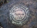
 view gallery view galleryNW20.8 km | WILCOX (MO0969) - Albany County, Wyoming in U.S. Benchmarks A triangulation station on the west side of U.S. 30/287, about 3.5 miles north of Rock River. posted by: Tom.dog location: Wyoming date approved: 11/21/2022 last visited: never |
 view gallery view galleryNW20.8 km | WILCOX NO 2 - Albany County, Wyoming in U.S. Benchmarks Reference mark 2 for triangulation station WILCOX. posted by: Tom.dog location: Wyoming date approved: 11/21/2022 last visited: never |
 view gallery view galleryNW20.8 km | U 321 (MO0730) - Albany County, Wyoming in U.S. Benchmarks A benchmark disk to the west of US 30/287. posted by: Tom.dog location: Wyoming date approved: 11/21/2022 last visited: never |
 view gallery view gallery W22.7 km W22.7 km
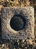
|  T19N R77W S8 S17 1/4 - Carbon and Albany Counties, Wyoming T19N R77W S8 S17 1/4 - Carbon and Albany Counties, Wyoming
in Public Land Survey Marks A privately monumented quarter corner marker on the boundary of Carbon County and Albany County. posted by: Tom.dog location: Wyoming date approved: 04/17/2023 last visited: never |
 view gallery view gallery E23.7 km E23.7 km
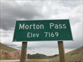
| Morton Pass, Albany County, Wyoming - 7,169' in Elevation Signs The summit of Morton Pass is marked by two signs on either side of State Highway 34 that display the elevation of the pass. posted by: Tom.dog location: Wyoming date approved: 08/11/2023 last visited: never |
|