 view gallery view gallery N0.6 km N0.6 km
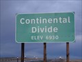
|   Continental Divide - Elevation 6930 Continental Divide - Elevation 6930
in Elevation Signs The Continental Divide crosses I-80 in several places in Wyoming, and here, the elevation is 6930 feet above sea level. posted by:  QuarrellaDeVil QuarrellaDeVil location: Wyoming date approved: 10/03/2015 last visited: 05/14/2021 |
 view gallery view gallery W22.4 km W22.4 km
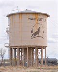
|  Mama Sage Mama Sage
in Flora and Fauna Information Signs This Wyoming Wildlife sign is located in the Bitter Creek Rest Area on the south side of eastbound Interstate Highway 80 east of Rock Springs, Wyoming. posted by: brwhiz location: Wyoming date approved: 09/28/2012 last visited: 07/03/2017 |
 view gallery view gallery E24.5 km E24.5 km
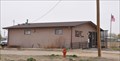
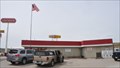
|  Wamsutter, Wyoming 82336 Wamsutter, Wyoming 82336
in U.S. Post Offices This Post Office is located at 302 Broadway Street in Wamsutter, Wyoming. posted by: brwhiz location: Wyoming date approved: 05/05/2012 last visited: never |
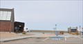
 view gallery view galleryE24.6 km |  Wamsutter, Wyoming Water Tower Wamsutter, Wyoming Water Tower
in Water Towers This water tower is located southeast of Wamsutter Crooks Gap Road adjacent to the Union Pacific Railroad Tracks. posted by: brwhiz location: Wyoming date approved: 10/01/2012 last visited: never |
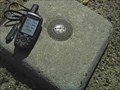 view gallery view galleryE38.3 km |  Latham #3 Latham #3
in U.S. Benchmarks Part of the Latham system west of communication tower and west of the Latham benchmark about 25 yards. On Continental Divide Road in Sweetwater County Wyoming. As of the date of this posting the marker was not in the NGS logs that I could find. posted by: Jake81499 location: Wyoming date approved: 08/22/2007 last visited: never |
 view gallery view galleryE38.9 km | MP0676 ~ LATHAM USGS No. 2 in U.S. Benchmarks This Azimuth Mark and Reference Mark 2 for the USGS Latham Survey Disk is located on the south side of the gravel road that follows the Pacific Branch of the Continental Divide northwest of Interstate 80 Exit 184. posted by: brwhiz location: Wyoming date approved: 01/23/2013 last visited: never |
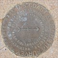 view gallery view galleryE38.9 km |  MP0676 ~ LATHAM USGS No. 2 MP0676 ~ LATHAM USGS No. 2
in Azimuth Benchmarks This Azimuth Mark and Reference Mark 2 for the USGS Latham Survey Disk is located on the south side of the gravel road that follows the Pacific Branch of the Continental Divide northwest of Interstate 80 Exit 184. posted by: brwhiz location: Wyoming date approved: 01/26/2013 last visited: never |
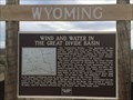
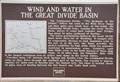 view gallery view galleryE40.9 km |  Wind and Water in the Great Divide Basin Wind and Water in the Great Divide Basin
in Wyoming Historical Markers This marker, along with another, is located on a hilltop a short distance southwest of the Interstate Highway 80 Exit 184 interchange. posted by: brwhiz location: Wyoming date approved: 09/22/2012 last visited: 05/05/2021 |
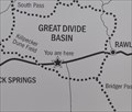 view gallery view galleryE40.9 km |  Great Divide Basin Great Divide Basin
in 'You Are Here' Maps You Are Here at two historical markers just souith of Interstate Highway 80 in the Great Divide Basin and a short distance southeast of the Killpecker Dune Field. posted by: brwhiz location: Wyoming date approved: 09/08/2012 last visited: 05/05/2021 |
 view gallery view galleryE40.9 km |  The Great Divide Basin - Rawlins, WY The Great Divide Basin - Rawlins, WY
in Watershed Markers and Monuments Located along I-80 at the Continental Divide. posted by: bluesnote location: Wyoming date approved: 10/03/2017 last visited: 06/14/2021 |
 view gallery view galleryE40.9 km |  Wind and Water in The Great Divide Basin - Rawlins, WY Wind and Water in The Great Divide Basin - Rawlins, WY
in Lincoln Highway Located along I-80 at the Continental Divide. posted by: bluesnote location: Wyoming date approved: 10/03/2017 last visited: 06/14/2021 |
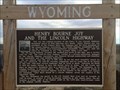
 view gallery view galleryE40.9 km | Henry Bourne Joy and the Lincoln Highway - Rawlins, WY in Lincoln Highway A pair of historical markers in the middle of nowhere off of I-80. posted by: bluesnote location: Wyoming date approved: 10/03/2017 last visited: 03/22/2022 |
 view gallery view galleryE40.9 km |  Henry Bourne Joy - Lincoln Highway - Rawlins, WY Henry Bourne Joy - Lincoln Highway - Rawlins, WY
in Etched in Stone A pair of historical markers in the middle of nowhere off of I-80. posted by: bluesnote location: Wyoming date approved: 10/09/2017 last visited: 03/22/2022 |
 view gallery view galleryE40.9 km |  Henry Bourne Joy and the Lincoln Highway - Rawlins, WY Henry Bourne Joy and the Lincoln Highway - Rawlins, WY
in Citizen Memorials A pair of historical markers in the middle of nowhere off of I-80. posted by: bluesnote location: Wyoming date approved: 10/08/2017 last visited: 03/22/2022 |
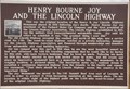 view gallery view galleryE40.9 km | Henry Bourne Joy and the Lincoln Highway in Wyoming Historical Markers This marker has the same title but different wording as another marker at the Interstate 80 (Lincoln Highway) summit southeast of Laramie. posted by: brwhiz location: Wyoming date approved: 09/22/2012 last visited: 09/03/2018 |
 view gallery view galleryE40.9 km |  OLDEST -- US Transcontinental Automobile Route - Rawlins, WY OLDEST -- US Transcontinental Automobile Route - Rawlins, WY
in Superlatives A pair of historical markers in the middle of nowhere off of I-80. posted by: bluesnote location: Wyoming date approved: 10/04/2017 last visited: 09/03/2018 |
 view gallery view galleryE40.9 km | Henry Bourne Joy and the Lincoln Highway - Rawlins, WY in Lincoln Highway Markers A pair of historical markers in the middle of nowhere off of I-80. posted by: bluesnote location: Wyoming date approved: 10/03/2017 last visited: 09/03/2018 |
 view gallery view galleryE40.9 km |  FIRST -- US Transcontinental Automobile Route - Rawlins, WY FIRST -- US Transcontinental Automobile Route - Rawlins, WY
in First of its Kind A pair of historical markers in the middle of nowhere off of I-80. posted by: bluesnote location: Wyoming date approved: 10/03/2017 last visited: 09/03/2018 |
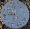 view gallery view galleryE40.9 km |  CEPI REC COM 1990 LS 5528 - Rawlins, WY CEPI REC COM 1990 LS 5528 - Rawlins, WY
in Public Land Survey Marks This survey mark is located near two historical makers. posted by: bluesnote location: Wyoming date approved: 08/28/2014 last visited: 08/27/2014 |
 view gallery view galleryE40.9 km | CEPI REC COM 1990 LS 5528 in U.S. Benchmarks This private survey mark is located on the south side of the Old US Highway roadbed just southwest of Interstate 80 Exit 184 east of Wamsutter, Wyoming. posted by: brwhiz location: Wyoming date approved: 01/23/2013 last visited: 08/28/2014 |
 view gallery view galleryW43.5 km |  Overland/Cherokee Trail - Point of Rocks, Wyoming Overland/Cherokee Trail - Point of Rocks, Wyoming
in Wagon Roads and Trails In 1849 a group of whites and Cherokee Indians embarked on a journey from Arkansas to the gold mines of California. The trail they followed became known as the Cherokee Trail. posted by:  Hikenutty Hikenutty location: Wyoming date approved: 07/11/2007 last visited: 07/03/2017 |
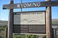 view gallery view galleryW43.5 km | Overland Stage Route - Point of Rocks, Wyoming in Wyoming Historical Markers The Overland Stage Route moved south to this area when the northern route was regularly attacked by Native Americans. posted by: Hikenutty location: Wyoming date approved: 07/10/2007 last visited: 07/03/2017 |
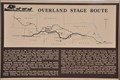 view gallery view galleryW43.5 km | Overland Stage Route ~ Point of Rocks, Wyoming in Wagon Roads and Trails This Overland Stage Route Marker is located on the south side of Interstate Highway 80 at Exit 130. posted by: brwhiz location: Wyoming date approved: 10/02/2012 last visited: 07/03/2017 |
 view gallery view galleryW43.8 km | Point of Rocks, Wyoming 82942 in U.S. Post Offices This Post Office is located at 7 Halter And Flick Street in Point of Rocks, Wyoming. posted by: brwhiz location: Wyoming date approved: 05/04/2012 last visited: never |
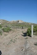
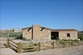 view gallery view galleryW44.3 km |  Point of Rocks Stage Station - Point of Rocks, WY Point of Rocks Stage Station - Point of Rocks, WY
in Official Local Tourism Attractions This building was built in 1861 as a stagecoach station along the Overland Stage Line. It later served as a Pony Express station, a school and a residence. posted by: Hikenutty location: Wyoming date approved: 07/19/2007 last visited: 11/04/2011 |
|