 view gallery view gallery NW8.4 km NW8.4 km
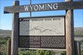
|   Overland Stage Route - Point of Rocks, Wyoming Overland Stage Route - Point of Rocks, Wyoming
in Wyoming Historical Markers The Overland Stage Route moved south to this area when the northern route was regularly attacked by Native Americans. posted by:  Hikenutty Hikenutty location: Wyoming date approved: 07/10/2007 last visited: 07/03/2017 |
 view gallery view galleryNW8.4 km |  Overland/Cherokee Trail - Point of Rocks, Wyoming Overland/Cherokee Trail - Point of Rocks, Wyoming
in Wagon Roads and Trails In 1849 a group of whites and Cherokee Indians embarked on a journey from Arkansas to the gold mines of California. The trail they followed became known as the Cherokee Trail. posted by: Hikenutty location: Wyoming date approved: 07/11/2007 last visited: 07/03/2017 |
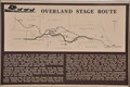 view gallery view galleryNW8.4 km | Overland Stage Route ~ Point of Rocks, Wyoming in Wagon Roads and Trails This Overland Stage Route Marker is located on the south side of Interstate Highway 80 at Exit 130. posted by:  brwhiz brwhiz location: Wyoming date approved: 10/02/2012 last visited: 07/03/2017 |
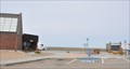
 view gallery view galleryNW8.7 km |  Point of Rocks, Wyoming Point of Rocks, Wyoming
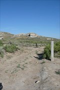
in American Guide Series Point of Rocks is nearly a ghost town at this point. The most well known feature of the town is its Overland Stage Station, built in 1861. posted by: Hikenutty location: Wyoming date approved: 08/17/2007 last visited: 11/08/2011 |
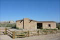 view gallery view galleryNW8.7 km | Almond Stage Station - Point of Rocks, Wyoming in American Guide Series This building was built in 1861 as a stagecoach station along the Overland Stage Line. It later served as a Pony Express station, a school and a residence. posted by: Hikenutty location: Wyoming date approved: 09/06/2007 last visited: 11/08/2011 |
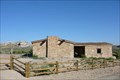
 view gallery view galleryNW8.7 km |  Point of Rocks Stage Station - Point of Rocks, WY Point of Rocks Stage Station - Point of Rocks, WY
in Official Local Tourism Attractions This building was built in 1861 as a stagecoach station along the Overland Stage Line. It later served as a Pony Express station, a school and a residence. posted by: Hikenutty location: Wyoming date approved: 07/19/2007 last visited: 11/04/2011 |
 view gallery view galleryNW8.7 km |  Point of Rocks School - Point of Rocks, Wyoming Point of Rocks School - Point of Rocks, Wyoming
in Former Schools This building, originally a stagecoach stop, became a school in 1877 when the stagecoach line through the area was abandoned. posted by: Hikenutty location: Wyoming date approved: 07/11/2007 last visited: 11/08/2011 |
 view gallery view galleryNW8.7 km |  Overland Stage Station - Point of Rocks, Wyoming Overland Stage Station - Point of Rocks, Wyoming
in Photos Then and Now This building was built in 1861 as a stagecoach station along the Overland Trail. posted by: Hikenutty location: Wyoming date approved: 07/19/2007 last visited: 05/30/2016 |
 view gallery view galleryNW8.7 km |  Point of Rocks Stage Station - Point of Rocks, WY Point of Rocks Stage Station - Point of Rocks, WY
in U.S. National Register of Historic Places This building was built in 1861 as a stagecoach station along the Overland Stage Line. It later served as a Pony Express station, a school and a residence. posted by: Hikenutty location: Wyoming date approved: 07/19/2007 last visited: 11/04/2011 |
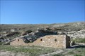
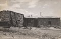
 view gallery view galleryNW8.7 km |  Overland Stagecoach Station Barn - Point of Rocks, WY Overland Stagecoach Station Barn - Point of Rocks, WY
in Barns This is the ruins of the Almond Stage Station barn, a stop along the Overland Stagecoach line and the Pony Express. The station has been restored, but the barn was left in ruins. posted by: Hikenutty location: Wyoming date approved: 03/14/2008 last visited: 11/08/2011 |
 view gallery view galleryNW8.7 km |  Overland Stage Station - Point of Rocks, WY Overland Stage Station - Point of Rocks, WY
in Lincoln Highway Long before the Lincoln Highway was routed through this area, the Overland Stage Line used the passage. Here you'll find a beautifully preserved stage station and part of its barn. posted by: Hikenutty location: Wyoming date approved: 07/15/2008 last visited: 11/04/2011 |
 view gallery view galleryNW8.7 km |  Point of Rocks, Wyoming 82942 Point of Rocks, Wyoming 82942
in U.S. Post Offices This Post Office is located at 7 Halter And Flick Street in Point of Rocks, Wyoming. posted by: brwhiz location: Wyoming date approved: 05/04/2012 last visited: never |
 view gallery view gallery E17.5 km E17.5 km
|  Mama Sage Mama Sage
in Flora and Fauna Information Signs This Wyoming Wildlife sign is located in the Bitter Creek Rest Area on the south side of eastbound Interstate Highway 80 east of Rock Springs, Wyoming. posted by: brwhiz location: Wyoming date approved: 09/28/2012 last visited: 07/03/2017 |
 view gallery view galleryNW25.1 km |  Superior, Wyoming ~ Population 244 Superior, Wyoming ~ Population 244
in Population Signs This combination Elevation/Population sign is at the southern town limits of Superior, Wyoming on Wyoming Highway 371. posted by: brwhiz location: Wyoming date approved: 09/08/2012 last visited: never |
 view gallery view galleryNW25.1 km |  Superior, Wyoming ~ Elevation 6700 Feet Superior, Wyoming ~ Elevation 6700 Feet
in Elevation Signs This combination Elevation/Population sign is at the southern town limits of Superior, Wyoming on Wyoming Highway 371. posted by: brwhiz location: Wyoming date approved: 09/08/2012 last visited: never |
 view gallery view galleryNW25.6 km | Superior, Wyoming 82945 in U.S. Post Offices This Post Office is located at 81 Main Street in Superior, Wyoming. posted by: brwhiz location: Wyoming date approved: 05/04/2012 last visited: never |
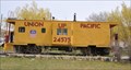 view gallery view galleryNW25.6 km |  Union Pacific Caboose 24575 ~ Superior, Wyoming Union Pacific Caboose 24575 ~ Superior, Wyoming
in Train Cabooses This caboose is just north of the Superior Post Office in a greenbelt between Main Street and Front Street. posted by: brwhiz location: Wyoming date approved: 09/25/2012 last visited: never |
 view gallery view gallery W29.6 km W29.6 km
|  WyDOT SWBR 54 WyDOT SWBR 54
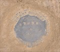
in U.S. Benchmarks This Wyoming Department of Transportation Survey Mark is located on the northeast side of Wyoming Highway just west of the Rock Springs - Sweetwater County Airport. posted by: brwhiz location: Wyoming date approved: 01/23/2013 last visited: never |
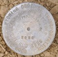 view gallery view galleryW29.8 km | WyDOT Proj - 1904006 2238 PLS 2928 Date 2009 in U.S. Benchmarks This Wyoming Department of Transportation Survey Mark is located on the northeast side of Wyoming Highway just west of the Rock Springs - Sweetwater County Airport. posted by: brwhiz location: Wyoming date approved: 01/23/2013 last visited: never |
 view gallery view galleryW38.1 km |  R is for Reliance - Reliance WY R is for Reliance - Reliance WY
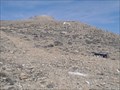
in Letters on Hills This 25-foot tall "R" is situated on more of a slope than a hill, making it somewhat difficult to get a decent shot of it. But it is there, nonetheless. Just a few short miles north of Rock Springs, Wyoming. posted by: Where's George location: Wyoming date approved: 04/25/2014 last visited: never |
 view gallery view galleryW38.3 km |  Sweetwater County Library - Reliance Branch - Reliance WY Sweetwater County Library - Reliance Branch - Reliance WY
in Libraries This small building houses one of the outlying branches of the Sweetwater County Library - 1329 Main Street, in Reliance. posted by: Where's George location: Wyoming date approved: 05/02/2014 last visited: never |
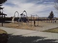 view gallery view galleryW38.5 km |  Reliance Park - Reliance WY Reliance Park - Reliance WY
in Municipal Parks and Plazas "North of Rock Springs, take Highway 191 and then take the Reliance Exit. Continue on the main road for 2.3 miles." posted by: Where's George location: Wyoming date approved: 08/30/2014 last visited: never |
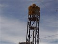 view gallery view galleryW38.5 km |  Reliance Storm Warning Siren - Reliance WY Reliance Storm Warning Siren - Reliance WY
in Outdoor Warning Sirens As storm warning sirens go, I'm going to guess that THIS one packs a pretty good punch!!! A double layer of "trumpet" style horns ring around this unit, making it audible for quite a distance. posted by: Where's George location: Wyoming date approved: 05/05/2014 last visited: never |
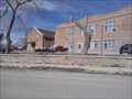 view gallery view galleryW38.5 km | Reliance School and Gymnasium - Reliance WY in U.S. National Register of Historic Places This old school building and complex was built to acomodate the children of the old coal mining community of Reliance. posted by: Where's George location: Wyoming date approved: 08/30/2014 last visited: never |
 view gallery view galleryW38.5 km | Rock Springs, Wyoming ~ Population 18,708 in Population Signs This combination Elevation/Population sign is at the eastern city limits of Rock Springs, Wyoming on 9th Street at the Interstate 80, Exit 107 offramp. posted by: brwhiz location: Wyoming date approved: 09/08/2012 last visited: never |
|