 view gallery view gallery SW3.2 km SW3.2 km
|   Observatory Park - 1254 Feet - Montville, Ohio Observatory Park - 1254 Feet - Montville, Ohio
in Elevation Signs Observatory Park is a part of the Geauga Park District in northeast Ohio. posted by:  miatabug miatabug location: Ohio date approved: 02/12/2012 last visited: 09/20/2015 |
 view gallery view gallerySW3.2 km |  N 41 34.991 W 081 04.295 - Observatory Park - Montville, Ohio N 41 34.991 W 081 04.295 - Observatory Park - Montville, Ohio
in Permanent Geographic Coordinates This sign is placed at the entrance to the drive for Geauga Park's Observatory Park. posted by: miatabug location: Ohio date approved: 02/06/2012 last visited: 09/20/2015 |
 view gallery view gallerySW3.5 km |  Compass Rose - Observatory Park, Montville Twp, Ohio Compass Rose - Observatory Park, Montville Twp, Ohio
in Compass Roses Compass Rose in the new Geauga Park District's Observatory Park. posted by: JoelMart location: Ohio date approved: 03/11/2012 last visited: 09/20/2015 |
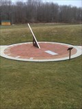 view gallery view gallerySW3.5 km |  Observatory Park Sundial, Montville Twp, Ohio, USA Observatory Park Sundial, Montville Twp, Ohio, USA
in Sundials Sundial in the new Geauga Park District's Observatory Park. posted by: JoelMart location: Ohio date approved: 03/09/2012 last visited: 09/20/2015 |
 view gallery view gallery W7.9 km W7.9 km
|  DO -- Hambden Township Park -- Hambden Township -- Ohio DO -- Hambden Township Park -- Hambden Township -- Ohio
in Places for Recycling This location is the Hambden Township recycling drop-off for the Geauga-Trumbell Solid Waste District. posted by: miatabug location: Ohio date approved: 05/24/2008 last visited: 09/17/2019 |
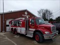 view gallery view galleryW7.9 km |  Tanker 3631 - Hambden, Ohio Tanker 3631 - Hambden, Ohio
in Fire Fighting Vehicles Hambden Fire Department's Tanker 3631 posted by: TyroneShoelaces location: Ohio date approved: 03/10/2018 last visited: 02/25/2018 |
 view gallery view gallery E8 km E8 km
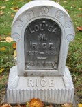
|  Rice - Hartsgrove Cemetery - Hartsgrove, Ohio Rice - Hartsgrove Cemetery - Hartsgrove, Ohio
in Zinc Headstones Zinc marker for Louisa M. Rice posted by:  lp5324 lp5324 location: Ohio date approved: 11/02/2008 last visited: never |
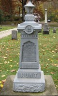 view gallery view galleryE8 km | Hunt - Hartsgrove Twp Cemetery - Hartsgrove, Ohio in Zinc Headstones Zinc marker for Seymour M. Hunt posted by: lp5324 location: Ohio date approved: 11/02/2008 last visited: never |
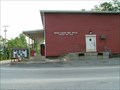
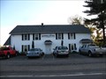 view gallery view galleryW8 km |  Hambden Grange #2482 - Hambden Township, Ohio Hambden Grange #2482 - Hambden Township, Ohio
in Grange Halls This two-story building is the grange hall for Hambden Grange (2482). posted by: miatabug location: Ohio date approved: 05/24/2008 last visited: 04/13/2016 |
 view gallery view gallery S8.4 km S8.4 km
|  Huntsburg Dari-Whip Huntsburg, Ohio Huntsburg Dari-Whip Huntsburg, Ohio
in Ice Cream Parlors Small ice cream stand in the rural township of Huntsburg Ohio posted by: miatabug location: Ohio date approved: 05/27/2008 last visited: never |
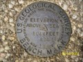 view gallery view gallery SE8.9 km SE8.9 km
|  USGS Benchmark - WDL 15 - Windsor, OH USGS Benchmark - WDL 15 - Windsor, OH
in U.S. Benchmarks USGS Benchmark WDL 15 (1044 FT) in Windsor, OH at the intersection of Plank Rd.(SR-86) and Stoneville Rd.(Cr-535). posted by: Team rbass location: Ohio date approved: 10/24/2007 last visited: never |
 view gallery view gallery N9 km N9 km
|  Fire Rescue Siren - Thompson, OH Fire Rescue Siren - Thompson, OH
in Outdoor Warning Sirens Thompson Fire Recue Siren in Thompson, OH. posted by: JoelMart location: Ohio date approved: 03/10/2012 last visited: 09/13/2015 |
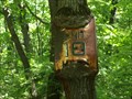 view gallery view galleryN9 km |  Sign Eating Tree - Thompson Ledges Park, Thompson, Ohio Sign Eating Tree - Thompson Ledges Park, Thompson, Ohio
in Omnivorous Trees This sign eating tree is found in Thompson Ledges Park, Thompson, (Geauga County) Ohio. posted by: buffalohiker location: Ohio date approved: 06/04/2012 last visited: 09/13/2015 |
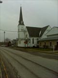 view gallery view galleryN9.2 km |  Thompson United Methodist Church - Thompson, OH Thompson United Methodist Church - Thompson, OH
in Methodist Churches United Methodist Church in Thompson, Ohio. posted by: JoelMart location: Ohio date approved: 03/17/2012 last visited: 09/13/2015 |
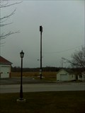
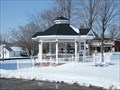 view gallery view galleryN9.2 km |  Gazebo - Thompson, Ohio Gazebo - Thompson, Ohio
in Gazebos This gazebo shares the large town square in Thompson, Ohio with the Town Hall. posted by: miatabug location: Ohio date approved: 02/24/2010 last visited: 12/16/2018 |
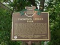 view gallery view galleryN9.2 km |  Thompson Ledges Park (6-28) Thompson Ledges Park (6-28)
in Ohio Historical Markers Two-sided historical marker showing one of Geauga County's oldest parks on one side and the geologic feature that helped create the park on the other. posted by: miatabug location: Ohio date approved: 07/07/2007 last visited: 12/16/2018 |
 view gallery view galleryN9.2 km |  Thompson, OH 44086 Thompson, OH 44086
in U.S. Post Offices Thompson is a township in the northeastern corner of Geauga County Ohio. posted by: miatabug location: Ohio date approved: 07/07/2007 last visited: 09/13/2015 |
 view gallery view galleryS9.5 km |  Corner Field Model Railroad Museum Corner Field Model Railroad Museum
in Model Railroads Corner Field Model Railroad Museum and Hobby has the largest family owned 3-rail layout in Ohio. It has over a thousand buildings, over 2,800 feet of track, and hundreds of freight cars. posted by: buffalohiker location: Ohio date approved: 08/18/2023 last visited: 03/04/2023 |
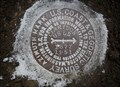 view gallery view gallerySW9.8 km |  CLARIDON AZ MK - Ohio CLARIDON AZ MK - Ohio
in Azimuth Benchmarks This is the azimuth mark for triangulation station CLARIDON RESET, in Claridon Township, Geauga County. posted by: shorbird location: Ohio date approved: 07/06/2011 last visited: 09/17/2019 |
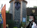 view gallery view gallery NE10.1 km NE10.1 km
|  Great Lakes Medieval Faire Great Lakes Medieval Faire
in Renaissance Fairs The Faire village of Avaloch posted by: Captain Chaoss location: Ohio date approved: 08/24/2008 last visited: 08/12/2012 |
 view gallery view galleryS10.1 km |  Geauga County Ohio Bicentennial Barn Geauga County Ohio Bicentennial Barn
in Barns In 2003, Ohio celebrated its 200th anniversary as a state. To observe the event, a barn was chosen from each county to have an anniversary logo painted by barn artist Scott Hagan on a prominent side. posted by: TyroneShoelaces location: Ohio date approved: 06/07/2016 last visited: 12/16/2018 |
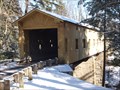 view gallery view gallerySE10.9 km |  Warner Hollow (35-04-25) - Ashtabula County, Ohio Warner Hollow (35-04-25) - Ashtabula County, Ohio
in Covered Bridges Warner Hollow Covered Bridge (35-04-25) over Phelps Creek on Wiswell Rd (TR 533) in Ashtabula County, Ohio. posted by: buffalohiker location: Ohio date approved: 03/09/2011 last visited: 08/13/2009 |
 view gallery view gallery NW11.4 km NW11.4 km
| Leroy Grange #1608 - LeRoy, Ohio in Grange Halls The Leroy Grange in Northeast Ohio is an active chapter. posted by: miatabug location: Ohio date approved: 02/23/2010 last visited: never |
 view gallery view gallerySW11.7 km |  Cow Crossing - East Claridon, Ohio Cow Crossing - East Claridon, Ohio
in Uncommon Crossing Signs Cow crossing sign on SR 608 posted by: lp5324 location: Ohio date approved: 09/21/2008 last visited: 09/17/2019 |
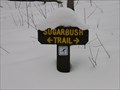 view gallery view galleryW11.7 km |  Sugarbush Trail - Whitlam Woods - Chardon Ohio Sugarbush Trail - Whitlam Woods - Chardon Ohio
in Cross Country Ski Trailheads This cross country trail is a relatively short loop through an old stand of sugar maples. posted by: miatabug location: Ohio date approved: 02/26/2010 last visited: 08/29/2015 |
|