 view gallery view gallery E27 km E27 km
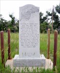
|   Deadwood Trail Marker, near Chugwater, WY Deadwood Trail Marker, near Chugwater, WY
in Wyoming Historical Markers This marks a stage station on the route between Cheyenne and Fort Laramie, and the route north to Montana and Dakota Territory posted by:  ronjean ronjean location: Wyoming date approved: 07/28/2011 last visited: 12/15/2014 |
 view gallery view gallery NW28.3 km NW28.3 km
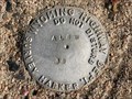
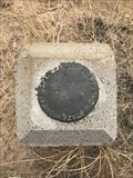
|  ALBW 38 - Albany County, Wyoming ALBW 38 - Albany County, Wyoming
in U.S. Benchmarks A Wyoming Highway Department survey marker near an abandoned section of highway grade. posted by:  Tom.dog Tom.dog location: Wyoming date approved: 08/13/2023 last visited: never |
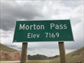 view gallery view galleryNW29.6 km |  Morton Pass, Albany County, Wyoming - 7,169' Morton Pass, Albany County, Wyoming - 7,169'
in Elevation Signs The summit of Morton Pass is marked by two signs on either side of State Highway 34 that display the elevation of the pass. posted by: Tom.dog location: Wyoming date approved: 08/11/2023 last visited: never |
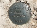
 view gallery view gallery N32.7 km N32.7 km
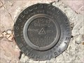
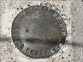
| P 166 RESET (AH7389) - Platte County, Wyoming in U.S. Benchmarks An NGS vertical control disk on the northwest side of State Highway 34. posted by: Tom.dog location: Wyoming date approved: 06/11/2023 last visited: never |
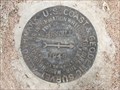
 view gallery view gallery SW32.8 km SW32.8 km
| PILOT NO 1 - Albany County, Wyoming in U.S. Benchmarks The U.S. Coast & Geodetic Survey's reference mark 1 for the USGS's PILOT 2 benchmark. posted by: Tom.dog location: Wyoming date approved: 07/31/2023 last visited: never |
 view gallery view gallerySW32.8 km | PILOT NO 2 NO 2 - Albany County, Wyoming in U.S. Benchmarks Reference mark 2 for USGS benchmark PILOT 2. posted by: Tom.dog location: Wyoming date approved: 07/31/2023 last visited: never |
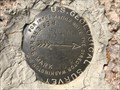
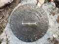
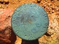
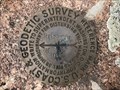
 view gallery view gallerySW32.8 km | PILOT 2 (MO1246) - Albany County, Wyoming in U.S. Benchmarks This USGS benchmark is located atop Pilot Hill, a local topographic landmark that rises to the east of the city of Laramie. posted by: Tom.dog location: Wyoming date approved: 07/31/2023 last visited: never |
 view gallery view gallerySW32.8 km | PILOT NO 2 NO 1 - Albany County, Wyoming in U.S. Benchmarks This is the USGS's reference mark 1 for PILOT 2 (not to be confused with the U.S. Coast & Geodetic Survey's reference mark 1 for the same benchmark). posted by: Tom.dog location: Wyoming date approved: 07/31/2023 last visited: never |
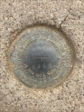
 view gallery view gallerySW34 km | PILOT Azimuth Mark - Albany County, Wyoming in U.S. Benchmarks A U.S. Coast & Geodetic Survey azimuth mark for USGS benchmark PILOT 2. posted by: Tom.dog location: Wyoming date approved: 07/31/2023 last visited: never |
 view gallery view gallerySW34 km |  PILOT Azimuth Mark - Albany County, Wyoming PILOT Azimuth Mark - Albany County, Wyoming
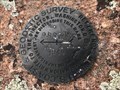
in Azimuth Benchmarks A U.S. Coast & Geodetic Survey-monumented azimuth mark for USGS benchmark PILOT 2 (MO1246). posted by: Tom.dog location: Wyoming date approved: 07/31/2023 last visited: never |
 view gallery view gallery W34.4 km W34.4 km
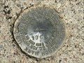
| C 167 (MO0754) - Albany County, Wyoming in U.S. Benchmarks This U.S. Coast & Geodetic Survey benchmark is on the northwest side of State Highway 34. posted by: Tom.dog location: Wyoming date approved: 06/25/2023 last visited: never |
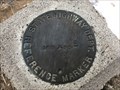
 view gallery view galleryW34.4 km | 7182 (MO0755) - Albany County, Wyoming in U.S. Benchmarks A State Highway Department reference marker on the northwest side of State Highway 34. posted by: Tom.dog location: Wyoming date approved: 06/25/2023 last visited: never |
 view gallery view gallerySW34.6 km | 8287 DENVER (AA2129) - Albany County, Wyoming in U.S. Benchmarks A USGS pipe cap to the southeast of Forest Service Road 712 (Telephone Road). posted by: Tom.dog location: Wyoming date approved: 11/21/2022 last visited: never |
 view gallery view gallerySW35.1 km | BGRS 1 (MO1247) - Albany County, Wyoming in U.S. Benchmarks A USGS benchmark on the south side of Forest Service Road 712 (Telephone Road). posted by: Tom.dog location: Wyoming date approved: 11/21/2022 last visited: never |
 view gallery view galleryW35.4 km | 7120 (MO0758) - Albany County, Wyoming in U.S. Benchmarks A Wyoming State Highway Department reference marker on the northwest side of State Highway 34. posted by: Tom.dog location: Wyoming date approved: 01/08/2023 last visited: never |
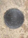
 view gallery view gallery S35.6 km S35.6 km
| RUSSELL RM 1 (MO1221) - Albany County, Wyoming in U.S. Benchmarks Reference mark 1 for triangulation station RUSSELL (MO1220). posted by: Tom.dog location: Wyoming date approved: 06/25/2023 last visited: never |
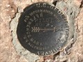
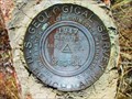
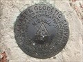 view gallery view galleryS35.6 km | RUSSELL (MO1220) - Albany County, Wyoming in U.S. Benchmarks This is a 1912 triangulation station on top of a granite knob in the Pole Mountain unit of Medicine Bow National Forest. posted by: Tom.dog location: Wyoming date approved: 06/25/2023 last visited: never |
 view gallery view galleryS35.6 km | RUSSELL NO 2 - Albany County, Wyoming in U.S. Benchmarks Reference mark 2 for triangulation station RUSSELL (MO1220). posted by: Tom.dog location: Wyoming date approved: 06/25/2023 last visited: never |
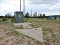 view gallery view gallerySW35.9 km |  Transcontinental Airmail Beacon Site - Albany County, WY Transcontinental Airmail Beacon Site - Albany County, WY
in Ground Based Air Navigation Support Structures This concrete arrow, once painted yellow and visible from the air, helped guide airmail pilots in the 1920s toward Cheyenne, Wyoming. Now it’s all that’s left of the former beacon station. posted by: hykesj location: Wyoming date approved: 08/03/2023 last visited: never |
 view gallery view galleryW35.9 km | 48 (MO0610) - Albany County, Wyoming in U.S. Benchmarks A U.S. Coast & Geodetic Survey and State Survey disk on the northeast side of U.S. Highway 287/30. posted by: Tom.dog location: Wyoming date approved: 04/17/2023 last visited: never |
 view gallery view galleryN36 km | N 166 RESET (MO1339) - Platte County, Wyoming in U.S. Benchmarks An NGS vertical control mark on the west side of State Highway 34. posted by: Tom.dog location: Wyoming date approved: 12/09/2022 last visited: never |
 view gallery view galleryS36.2 km | RUSSELL Azimuth Mark - Albany County, Wyoming in U.S. Benchmarks This is the azimuth mark for triangulation station RUSSELL (MO1220). posted by: Tom.dog location: Wyoming date approved: 06/25/2023 last visited: never |
 view gallery view galleryS36.2 km | RUSSELL Azimuth Mark - Albany County, Wyoming in Azimuth Benchmarks The azimuth mark for triangulation station RUSSELL (MO1220). posted by: Tom.dog location: Wyoming date approved: 07/02/2023 last visited: never |
 view gallery view galleryW36.5 km | A 167 (MO0759) - Albany County, Wyoming in U.S. Benchmarks A U.S. Coast & Geodetic Survey benchmark on the southeast side of State Highway 34. posted by: Tom.dog location: Wyoming date approved: 12/09/2022 last visited: never |
 view gallery view galleryW36.5 km | 7059 (MO0760) - Albany County, Wyoming in U.S. Benchmarks A Wyoming State Highway Department reference marker on the southeast side of State Highway 34. posted by: Tom.dog location: Wyoming date approved: 12/09/2022 last visited: never |
|