 view gallery view gallery W6.1 km W6.1 km
|   Papa's Fishing Lake - PRIVATE Papa's Fishing Lake - PRIVATE
in Fishing Holes MrMogger took the MiniMoggers to Nana and Papa's for a little early Christmas party last year and decided to go on a fishing expedition on Nana and Papa's private lake near Hawley, Pennsylvania. posted by:  unimoggers unimoggers location: Pennsylvania date approved: 04/09/2008 last visited: never |
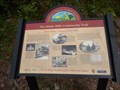
 view gallery view gallery E6.6 km E6.6 km
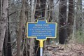
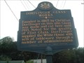
|  Indian Raid Indian Raid
in New York Historical Markers NEAR THIS SITE IN 1763
A SETTLEMENT WAS DESTROYED
BY THE DELAWARE TRIBE
FROM WYOMING VALLEY PA
THERE WERE NO SURVIVORS posted by:  rubin18 rubin18 location: New York date approved: 03/31/2019 last visited: never |
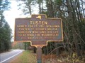 view gallery view galleryE7.1 km | TUSTEN in New York Historical Markers Main Street overlooks the widest eddy in the Delaware River that is frequently crisscrossed by eagles. posted by: unimoggers location: New York date approved: 11/03/2006 last visited: 05/06/2011 |
 view gallery view gallery N8 km N8 km
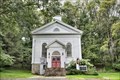
|  Narrowsburg Methodist Church - Narrowsburg NY Narrowsburg Methodist Church - Narrowsburg NY
in U.S. National Register of Historic Places Narrowsburg Methodist Church was built in 1856 and is a frame, Greek Revival style meeting house. posted by: nomadwillie location: New York date approved: 10/16/2019 last visited: never |
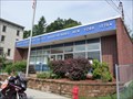 view gallery view galleryN8.4 km |  Narrowsburg, NY 12764 Narrowsburg, NY 12764
in U.S. Post Offices Located at 75 Main Street, Narrowsburg, NY posted by: nomadwillie location: New York date approved: 06/01/2011 last visited: 08/16/2013 |
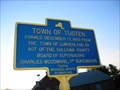 view gallery view galleryN8.5 km | TOWN OF TUSTEN in New York Historical Markers I found this on US 97 along the Delaware River in Sullivan County, NY. I thought I had already found this, but this one is newer than the other Tusten sign. posted by: unimoggers location: New York date approved: 06/04/2007 last visited: 05/06/2011 |
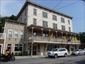 view gallery view galleryN8.5 km | Arlington Hotel - Narrowsburg NY in U.S. National Register of Historic Places Houses the National Park Service Visitor Center for the Upper Delaware Scenic and Recreational River. posted by: nomadwillie location: New York date approved: 06/01/2011 last visited: 07/23/2010 |
 view gallery view galleryN8.5 km |  Upper Delaware S&RR Narrowsburg PA Upper Delaware S&RR Narrowsburg PA
in NPS Passport Cancellation Stations Rolling hills, riverfront villages, and bald eagles perched on trees form a vibrant backdrop as the Delaware River snakes gracefully through the rural countryside. posted by: nomadwillie location: Pennsylvania date approved: 11/10/2008 last visited: 02/24/2023 |
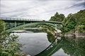 view gallery view galleryN8.5 km |  Narrowsburg–Darbytown Bridge - Narrowsburg, NY Narrowsburg–Darbytown Bridge - Narrowsburg, NY
in Arch Bridges The Narrowsburg–Darbytown Bridge is an arch under bridge spanning the Delaware River between Darbytown, Pennsylvania and Narrowsburg, New York. posted by: nomadwillie location: New York date approved: 10/15/2019 last visited: never |
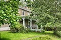 view gallery view galleryN8.7 km | Kirk House - Narrowsburg NY in U.S. National Register of Historic Places The Kirk House was originally built as a school house in the 1840's, moved to its current location in 1875, when a second story was added. posted by: nomadwillie location: New York date approved: 10/16/2019 last visited: never |
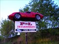 view gallery view gallery NW8.9 km NW8.9 km
|  P&L Transmission near Beach Lake, PA P&L Transmission near Beach Lake, PA
in Art Vehicles Suspended in air hoping to grab your attention... after all, it is a Vette! posted by: unimoggers location: Pennsylvania date approved: 04/13/2008 last visited: 04/29/2011 |
 view gallery view galleryW9 km |  From Alsace, France to White Mills - White Mills PA From Alsace, France to White Mills - White Mills PA
in Signs of History Eugene A. Dorflinger Sr., Christian Dorflinger’s cousin who had also emigrated from Alsace, established a general store in White Mills in 1869. posted by: Don.Morfe location: Pennsylvania date approved: 05/30/2020 last visited: 09/26/2021 |
 view gallery view galleryW9 km | Watching Over Their Livelihood and Their Homes - White Mills PA in Signs of History The earliest fire protection in White Mills was likely informal bucket brigades---neighbors pitching to help when needed. posted by: Don.Morfe location: Pennsylvania date approved: 05/30/2020 last visited: 09/26/2021 |
 view gallery view galleryW9 km | The Canal and the Rails Spark the Growth of White Mills - White Mills PA in Signs of History Transportation was essential to the success of the Dorflinger glassmaking enterprise. With its location on the banks of the Delaware and Hudson Canal, White Mills was positioned to receive raw materials by canal boat. posted by: Don.Morfe location: Pennsylvania date approved: 05/30/2020 last visited: 09/26/2021 |
 view gallery view galleryW9.2 km |  DORFLINGER GLASS WORKS DORFLINGER GLASS WORKS
in Pennsylvania Historical Markers Please follow Elizabeth street north and follow the signs to the present site. Take a tour and enjoy the beauty of Dorflinger glass. posted by: unimoggers location: Pennsylvania date approved: 09/25/2005 last visited: 08/23/2010 |
 view gallery view galleryN9.2 km | Fort Delaware in New York Historical Markers Fort Delaware is located along scenic Route 97 in Narrowsburg, NY. If you're visiting the area on a weekend, feel free to stop by the fort and check out what life was like in the Upper Delaware Valley in 1754. posted by: lightning93 location: New York date approved: 05/10/2011 last visited: 05/11/2011 |
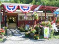 view gallery view gallery SW9.3 km SW9.3 km
|  PJ's Garden Center PJ's Garden Center
in Greenhouses and Nurseries PJ's Garden Center in White Mills, PA sells just about anything that could possibly clutter your front lawn. And in this area, there's a lot of that going on. Flags, statues, whirling things, you name it. posted by: unimoggers location: Pennsylvania date approved: 08/11/2007 last visited: never |
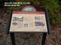
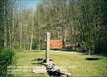
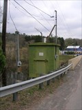 view gallery view gallerySW9.3 km |  USGS River Gaging Station # 01431500 USGS River Gaging Station # 01431500
in River Gauges Located on the Lackawanna River near Hawley, Pennsylvania, this river "gaging" station is operated by the USGS. posted by: unimoggers location: Pennsylvania date approved: 04/21/2008 last visited: never |
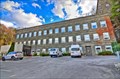 view gallery view gallerySW9.5 km | O'Connor, J.S., American Rich Cut Glassware Factory - Hawley PA in U.S. National Register of Historic Places Built on solid rock at the foot of Wallenpaupack Falls, it now serves the function of a hotel. posted by: nomadwillie location: Pennsylvania date approved: 11/23/2014 last visited: never |
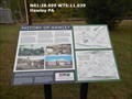 view gallery view gallerySW9.8 km | History of Hawley - Hawley PA in Signs of History In the late 18th century, pioneers moving west through the woodlands of Northeastern Pennsylvania found a place where three streams converged. posted by: Don.Morfe location: Pennsylvania date approved: 04/21/2020 last visited: 09/25/2021 |
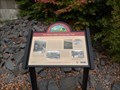
 view gallery view galleryN9.8 km |  Upper Delaware Scenic and Recreational River - Beach Lake PA Upper Delaware Scenic and Recreational River - Beach Lake PA
in Wikipedia Entries The Upper Delaware Scenic and Recreational River is a unit of the National Park Service designated under the National Wild and Scenic Rivers System. It stretches along 73.4 miles (118.1 km) of the Delaware River. posted by: Don.Morfe location: Pennsylvania date approved: 02/24/2023 last visited: 02/24/2023 |
 view gallery view galleryN9.8 km |  Upper Delaware Scenic and Recreational River - Beach Lake PA Upper Delaware Scenic and Recreational River - Beach Lake PA
in Official Local Tourism Attractions The Upper Delaware Scenic and Recreational River is a unit of the National Park Service designated under the National Wild and Scenic Rivers System. It stretches along 73.4 miles (118.1 km) of the Delaware River. posted by: Don.Morfe location: Pennsylvania date approved: 02/26/2023 last visited: 02/25/2023 |
 view gallery view galleryN9.8 km | ") Upper Delaware Scenic and Recreational River - Beach Lake PA Upper Delaware Scenic and Recreational River - Beach Lake PA
in National Parks (U.S.) The Upper Delaware Scenic and Recreational River is a unit of the National Park Service designated under the National Wild and Scenic Rivers System. It stretches along 73.4 miles (118.1 km) of the Delaware River. posted by: Don.Morfe location: Pennsylvania date approved: 02/25/2023 last visited: 02/25/2023 |
 view gallery view galleryN9.8 km |  Upper Delaware Scenic and Recreational River - Beach Lake PA Upper Delaware Scenic and Recreational River - Beach Lake PA
in National Parks of the World The Upper Delaware Scenic and Recreational River is a unit of the National Park Service designated under the National Wild and Scenic Rivers System. It stretches along 73.4 miles (118.1 km) of the Delaware River. posted by: Don.Morfe location: Pennsylvania date approved: 02/25/2023 last visited: 02/25/2023 |
 view gallery view galleryN9.8 km |  Upper Delaware Scenic and Recreational River - Beach Lake PA Upper Delaware Scenic and Recreational River - Beach Lake PA
in Ranger Stations There is a Ranger Station in the Visitor Center of the Upper Delaware Scenic and Recreational River national park. One may obtain a NPS Cancellation Stamp. posted by: Don.Morfe location: Pennsylvania date approved: 03/19/2023 last visited: 02/25/2023 |
|