 view gallery view gallery N5.1 km N5.1 km
|   RUSSELL NO 2 - Albany County, Wyoming RUSSELL NO 2 - Albany County, Wyoming
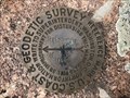
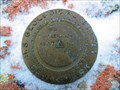
in U.S. Benchmarks Reference mark 2 for triangulation station RUSSELL (MO1220). posted by:  Tom.dog Tom.dog location: Wyoming date approved: 06/25/2023 last visited: never |
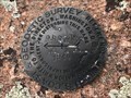
 view gallery view galleryN5.1 km | RUSSELL (MO1220) - Albany County, Wyoming in U.S. Benchmarks This is a 1912 triangulation station on top of a granite knob in the Pole Mountain unit of Medicine Bow National Forest. posted by: Tom.dog location: Wyoming date approved: 06/25/2023 last visited: never |
 view gallery view galleryN5.3 km | RUSSELL RM 1 (MO1221) - Albany County, Wyoming in U.S. Benchmarks Reference mark 1 for triangulation station RUSSELL (MO1220). posted by: Tom.dog location: Wyoming date approved: 06/25/2023 last visited: never |
 view gallery view gallery NW5.3 km NW5.3 km
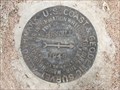
| RUSSELL Azimuth Mark - Albany County, Wyoming in U.S. Benchmarks This is the azimuth mark for triangulation station RUSSELL (MO1220). posted by: Tom.dog location: Wyoming date approved: 06/25/2023 last visited: never |
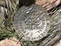
 view gallery view galleryNW5.3 km |  RUSSELL Azimuth Mark - Albany County, Wyoming RUSSELL Azimuth Mark - Albany County, Wyoming
in Azimuth Benchmarks The azimuth mark for triangulation station RUSSELL (MO1220). posted by: Tom.dog location: Wyoming date approved: 07/02/2023 last visited: never |
 view gallery view gallery SW7.4 km SW7.4 km
|  The Sherman Mountains -- I-80 at Tree Rock, Buford WY The Sherman Mountains -- I-80 at Tree Rock, Buford WY
in Places of Geologic Significance The Sherman Mountains are formed by fascinating geological forces posted by: Benchmark Blasterz location: Wyoming date approved: 02/23/2018 last visited: 09/20/2023 |
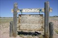
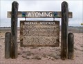 view gallery view gallerySW7.4 km |  Sherman Mountains Sherman Mountains
in Wyoming Historical Markers This marker tells about the geology of the nearby mountains. posted by:  NevaP NevaP location: Wyoming date approved: 06/07/2007 last visited: 09/20/2023 |
 view gallery view gallerySW7.4 km |  Tree Rock -- Buford WY Tree Rock -- Buford WY
in American Guide Series Tree Rock was a curiosity along the Union Pacific railroad in the era before cars, and along the Lincoln Highway after the automobile arrived posted by: Benchmark Blasterz location: Wyoming date approved: 02/24/2018 last visited: 09/20/2023 |
 view gallery view gallerySW7.4 km |  Tree Rock - Buford WY Tree Rock - Buford WY
in Official Local Tourism Attractions This Official Local Tourism Attraction is Tree Rock which is in the median of I-80, 2.5 miles west of Buford, Wyoming. posted by: PeterNoG location: Wyoming date approved: 10/15/2016 last visited: 09/20/2023 |
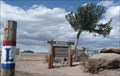
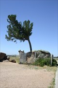
 view gallery view gallerySW7.4 km |  Tree in the Rock - Buford WY Tree in the Rock - Buford WY
in Roadside Attractions This Roadside Attraction is a Limber Pine growing in a granite boulder in the median of I-80, 2.5 miles west of Buford, Wyoming. posted by: PeterNoG location: Wyoming date approved: 10/14/2016 last visited: 09/20/2023 |
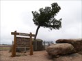
 view gallery view gallerySW7.4 km |  Lincoln Hwy Marker - Tree Rock - Buford WY Lincoln Hwy Marker - Tree Rock - Buford WY
in Lincoln Highway Markers This Lincoln Highway Marker is beside Tree Rock which is in the median of I-80, 2.5 miles west of Buford, Wyoming. posted by: PeterNoG location: Wyoming date approved: 10/23/2016 last visited: 09/20/2023 |
 view gallery view gallerySW7.4 km | Tree Rock -- Buford WY in Lincoln Highway Tree Rock was a curiosity along the Union Pacific railroad in the era before cars, and along the Lincoln Highway after the automobile arrived posted by: Benchmark Blasterz location: Wyoming date approved: 02/22/2018 last visited: 09/20/2023 |
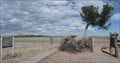
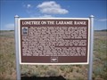 view gallery view gallerySW7.4 km | Lonetree on the Laramie Range in Wyoming Historical Markers In median of I-80 near Buford. posted by: Markerman62 location: Wyoming date approved: 01/28/2015 last visited: 09/20/2023 |
 view gallery view gallerySW7.4 km | Tree Rock in Wyoming Historical Markers This marker stands by a tree that has fascinated travelers for the past 140 years. posted by: NevaP location: Wyoming date approved: 06/07/2007 last visited: 09/20/2023 |
 view gallery view gallery S7.7 km S7.7 km
|  19th Century UPRR Water Tank -- Buford WY 19th Century UPRR Water Tank -- Buford WY
in Water Towers All that remains of the formerly critical UPRR infrastructre at Buford is an old water tank posted by: Benchmark Blasterz location: Wyoming date approved: 02/25/2018 last visited: 07/18/2005 |
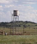 view gallery view galleryS7.7 km | Buford WY -- I-80 at Monument Road, Albany Co. WY in American Guide Series All that remains of the UPRR at Buford is an old water tank along the I-80 posted by: Benchmark Blasterz location: Wyoming date approved: 02/24/2018 last visited: 07/18/2005 |
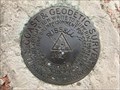
 view gallery view galleryNW9.2 km | POLE (MO1232) - Albany County, Wyoming in U.S. Benchmarks A USGS benchmark atop one of the high points of the Pole Mountain area on Medicine Bow National Forest. posted by: Tom.dog location: Wyoming date approved: 11/21/2022 last visited: never |
 view gallery view gallerySW10 km |  T14N R72W S25 36 R71W S30 S31 - Albany County, Wyoming T14N R72W S25 36 R71W S30 S31 - Albany County, Wyoming
in Public Land Survey Marks A GLO section corner marker on the southern boundary of the Pole Mountain unit of Medicine Bow National Forest. posted by: Tom.dog location: Wyoming date approved: 06/25/2023 last visited: never |
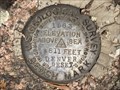 view gallery view gallery W10.1 km W10.1 km
| 8511 DENVER RESET - Albany County, Wyoming in U.S. Benchmarks A USGS benchmark on the northeast side of Blair Road. posted by: Tom.dog location: Wyoming date approved: 06/25/2023 last visited: never |
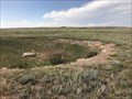 view gallery view gallerySW10.3 km |  Sherman Roundhouse - Albany County, Wyoming Sherman Roundhouse - Albany County, Wyoming
in Railway Roundhouses The Sherman Roundhouse, whose foundation can still be seen along the crest of the windswept Sherman Mountains, once sat at the highest point on the original grade of the Transcontinental Railroad. posted by: Tom.dog location: Wyoming date approved: 08/19/2023 last visited: never |
 view gallery view gallerySW10.5 km | Oakes and Oliver Ames Monument-- near Buford WY in Roadside Attractions The Oakes and Oliver Ames Monument, a landmark on the Lincoln Highway near Buford WY posted by: Benchmark Blasterz location: Wyoming date approved: 02/22/2018 last visited: 08/06/2023 |
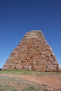
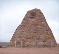 view gallery view gallerySW10.5 km |  Ames Monument - Sherman, WY Ames Monument - Sherman, WY
in U.S. National Register of Historic Places This massive pyramid of granite stands largely forgotten on the high plains of southeastern Wyoming. posted by: NevaP location: Wyoming date approved: 05/26/2007 last visited: 08/06/2023 |
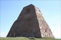 view gallery view gallerySW10.5 km | MO1233 Ames Monument -- near Buford WY in U.S. Benchmarks The Ames Monument east of Laramie WY is NGS Benchmark MO1233 posted by: Benchmark Blasterz location: Wyoming date approved: 02/22/2018 last visited: 11/05/2022 |
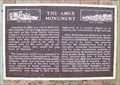 view gallery view gallerySW10.5 km | Ames Monument Historical Plaque in Wyoming Historical Markers This attractive plaque stands by the massive Ames monument. posted by: NevaP location: Wyoming date approved: 06/07/2007 last visited: 08/06/2023 |
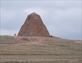 view gallery view gallerySW10.5 km |  Ames Monument Ames Monument
in Pyramids This massive pyramid of granite stands largely forgotten on the high plains of southeastern Wyoming. posted by: NevaP location: Wyoming date approved: 05/27/2007 last visited: 08/06/2023 |
|