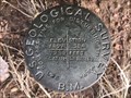
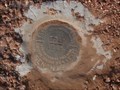
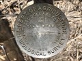
 view gallery view gallery NW7.7 km NW7.7 km
|   7239 LARAMIE - Albany County, WY 7239 LARAMIE - Albany County, WY
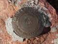
in U.S. Benchmarks A USGS benchmark on the southeast side of a bend in Sand Creek Road. posted by:  Tom.dog Tom.dog location: Wyoming date approved: 02/18/2023 last visited: never |
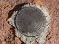
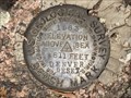
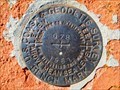 view gallery view gallery S8.7 km S8.7 km
| Q 78 (MO0655) - Albany County, Wyoming in U.S. Benchmarks A benchmark disk to the south of Sportsman Lake Road. posted by: Tom.dog location: Wyoming date approved: 11/21/2022 last visited: never |
 view gallery view galleryS8.7 km | P 78 (MO0654) - Albany County, Wyoming in U.S. Benchmarks A benchmark disk set in a sandstone outcrop off of Sportsman Lake Road. posted by: Tom.dog location: Wyoming date approved: 11/06/2022 last visited: never |
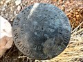
 view gallery view gallery SW8.9 km SW8.9 km
| R 78 (MO0656) - Albany County, Wyoming in U.S. Benchmarks This benchmark is located on the south side of Sportsman Lake Road in an area of plentiful rock outcrops. posted by: Tom.dog location: Wyoming date approved: 11/21/2022 last visited: never |
 view gallery view galleryS9.3 km | N 78 (MO0653) - Albany County, Wyoming in U.S. Benchmarks A benchmark disk set to the northeast of a bend in Sportsman Lake Road. posted by: Tom.dog location: Wyoming date approved: 11/06/2022 last visited: never |
 view gallery view galleryS9.3 km | M 78 (MO0652) - Albany County, Wyoming in U.S. Benchmarks Benchmark disk on the north side of Sportsman Lake Road. posted by: Tom.dog location: Wyoming date approved: 11/06/2022 last visited: never |
 view gallery view gallerySW9.5 km | S 78 (MO0657) - Albany County, Wyoming in U.S. Benchmarks A benchmark disk on the south side of Sportsman Lake Road as it nears the crest of Boulder Ridge. posted by: Tom.dog location: Wyoming date approved: 11/21/2022 last visited: never |
 view gallery view galleryS9.5 km | L 78 (MO0651) - Albany County, Wyoming in U.S. Benchmarks A benchmark disk on the northwest side of Sportsman Lake Road. posted by: Tom.dog location: Wyoming date approved: 11/06/2022 last visited: never |
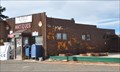
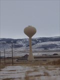 view gallery view gallery N10.5 km N10.5 km
|  Water Tower - Laramie, Wyoming Water Tower - Laramie, Wyoming
in Water Towers This is the watertower just outside of Laramie Wyoming posted by:  mangagkakawatak mangagkakawatak location: Wyoming date approved: 01/09/2006 last visited: 01/05/2008 |
 view gallery view gallerySW10.8 km | T 78 (MO0658) - Albany County, Wyoming in U.S. Benchmarks A benchmark on the north side of Sportsman Lake Road approximately 0.8 road miles west-southwest of the crest of Boulder Ridge. posted by: Tom.dog location: Wyoming date approved: 11/21/2022 last visited: never |
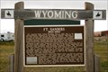 view gallery view galleryN10.9 km |  Fort Sanders - Laramie, WY Fort Sanders - Laramie, WY
in Wyoming Historical Markers Ft. Sanders protected travelers along the emigrant trails from 1866 to 1882 as well as crews for the construction of the Union Pacific Railroad. posted by: IJAdventures location: Wyoming date approved: 01/24/2014 last visited: 05/06/2021 |
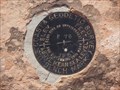
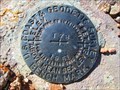
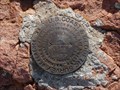
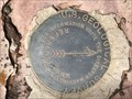
 view gallery view gallery SE11.1 km SE11.1 km
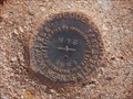
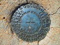
| HERMOSA AZ MK (MO0491) - Albany County, Wyoming in U.S. Benchmarks The azimuth mark for triangulation station HERMOSA. posted by: Tom.dog location: Wyoming date approved: 11/06/2022 last visited: never |
 view gallery view gallerySE11.1 km |  HERMOSA AZ MK (MO0491) - Albany County, Wyoming HERMOSA AZ MK (MO0491) - Albany County, Wyoming
in Azimuth Benchmarks The azimuth mark for triangulation station HERMOSA (MO0488), on the south side of Hermosa Road (County Road 222). posted by: Tom.dog location: Wyoming date approved: 07/02/2023 last visited: never |
 view gallery view gallerySE11.3 km | B 317 (MO0490) - Albany County, Wyoming in U.S. Benchmarks A benchmark disk located to the southwest of the historic Union Pacific Transcontinental Railroad grade. posted by: Tom.dog location: Wyoming date approved: 11/06/2022 last visited: never |
 view gallery view gallerySE11.3 km |  Tie Siding, Wyoming 82084 Tie Siding, Wyoming 82084
in U.S. Post Offices This Post Office is located at 1741 S US Highway 287 in Tie Siding, Wyoming. posted by: brwhiz location: Wyoming date approved: 05/07/2012 last visited: never |
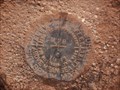
 view gallery view gallerySE11.3 km | HERMOSA RM 1 (MO0487) - Albany County, Wyoming in U.S. Benchmarks Reference mark 1 for triangulation station HERMOSA. posted by: Tom.dog location: Wyoming date approved: 11/06/2022 last visited: never |
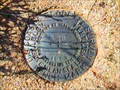
 view gallery view gallerySE11.3 km | HERMOSA RM 2 (MO0486) - Albany County, Wyoming in U.S. Benchmarks Reference mark 2 for triangulation station HERMOSA. posted by: Tom.dog location: Wyoming date approved: 11/06/2022 last visited: never |
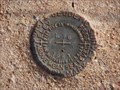
 view gallery view gallerySE11.3 km | HERMOSA (MO0488) - Albany County, Wyoming in U.S. Benchmarks A triangulation station located at the top of a small hill to the west of Hermosa Road in southern Albany County. posted by: Tom.dog location: Wyoming date approved: 11/06/2022 last visited: never |
 view gallery view gallerySW11.9 km | U 78 (MO0659) - Albany County, Wyoming in U.S. Benchmarks A benchmark on the south side of Sportsman Lake Road, about 0.3 miles east-southeast of the Lone Tree Creek crossing. posted by: Tom.dog location: Wyoming date approved: 11/21/2022 last visited: never |
 view gallery view gallery W12.1 km W12.1 km
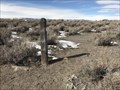
|  T14N R74W S9 W 1/16 - Albany County, Wyoming T14N R74W S9 W 1/16 - Albany County, Wyoming
in Public Land Survey Marks A USDA Biological Survey sixteenth corner disk from 1940 located along the boundary of the Hutton Lake National Wildlife Refuge. posted by: Tom.dog location: Wyoming date approved: 02/18/2023 last visited: never |
 view gallery view galleryW12.1 km | T14N R74W S17 S16 1/4 - Albany County, Wyoming in Public Land Survey Marks A partially buried quarter corner stone marker in the Hutton Lake National Wildlife Refuge. posted by: Tom.dog location: Wyoming date approved: 02/18/2023 last visited: never |
 view gallery view galleryW12.2 km | T14N R74W S8 S9 S17 S16 - Albany County, Wyoming in Public Land Survey Marks This 1932 USDA Biological Survey section corner disk is located in the Hutton Lake National Wildlife Refuge. posted by: Tom.dog location: Wyoming date approved: 02/18/2023 last visited: never |
 view gallery view gallery E12.2 km E12.2 km
| 8511 DENVER RESET - Albany County, Wyoming in U.S. Benchmarks A USGS benchmark on the northeast side of Blair Road. posted by: Tom.dog location: Wyoming date approved: 06/25/2023 last visited: never |
 view gallery view galleryW12.4 km | T14N R74W S8 S9 1/4 - Albany County, Wyoming in Public Land Survey Marks A USDI - Fish & Wildlife Service quarter corner marker on the boundary of the Hutton Lake National Wildlife Refuge. posted by: Tom.dog location: Wyoming date approved: 02/18/2023 last visited: never |
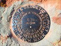
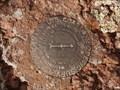
 view gallery view gallery NE12.4 km NE12.4 km
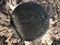
| CROW NO 2 - Albany County, Wyoming in U.S. Benchmarks Reference mark 2 for USGS benchmark CROW (MO1234). posted by: Tom.dog location: Wyoming date approved: 06/25/2023 last visited: never |
|