 view gallery view gallery S1.6 km S1.6 km
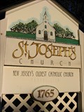
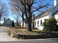
|   First Roman Catholic Church in New Jersey First Roman Catholic Church in New Jersey
in First of its Kind Organized in 1765, St. Josephs is the first and oldest Roman Catholic congregation in New Jersey. posted by:  briansnat briansnat location: New Jersey date approved: 08/11/2008 last visited: 08/26/2009 |
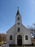 view gallery view galleryS1.6 km |  St Josephs Church - West Milford, NJ St Josephs Church - West Milford, NJ
in This Old Church Organized in 1765, St Josephs is the oldest Catholic church in New Jersey. The current sanctuary was built in 1905. posted by: briansnat location: New Jersey date approved: 04/10/2008 last visited: 08/26/2009 |
 view gallery view galleryS1.6 km | Saint Josephs - West Milford, NJ in Roman Catholic Churches Organized in 1765, St. Josephs is the oldest Roman Catholic congregation in New Jersey. posted by: briansnat location: New Jersey date approved: 04/10/2008 last visited: 08/26/2009 |
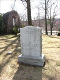 view gallery view galleryS1.6 km |  St Josephs Church Cemetery - West Milford, NJ St Josephs Church Cemetery - West Milford, NJ
in Churchyard Cemeteries Fairly large cemetery next to and associated with St Joshephs Roman Catholic Church. Founded in 1765 it's the oldest Catholic congregation in New Jersey. posted by: briansnat location: New Jersey date approved: 04/10/2008 last visited: 08/26/2009 |
 view gallery view gallery N2.1 km N2.1 km
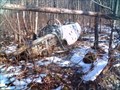
|  T2V-1 West Milford, NJ T2V-1 West Milford, NJ
in Plane Crash Sites Surrounded by swampy woods and dozens of theories. posted by:  KidRipley KidRipley location: New Jersey date approved: 02/21/2008 last visited: 05/19/2012 |
 view gallery view galleryN2.7 km | Echo Lake Baptist Church Churchyard - West Milford, NJ in Churchyard Cemeteries This tiny churchyard is in the shadow of Echo Lake Baptist Church in West Milford NJ. posted by: briansnat location: New Jersey date approved: 04/10/2008 last visited: 06/19/2011 |
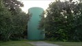 view gallery view galleryN2.9 km |  West Milford, NJ Water Tower West Milford, NJ Water Tower
in Water Towers This Water Tank is in West Milford, NJ. posted by:  79scouts 79scouts location: New Jersey date approved: 07/03/2011 last visited: never |
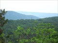
 view gallery view gallery SE4.5 km SE4.5 km
|  Osio Rock Osio Rock
in Scenic Overlooks This excellent, but relatively unknown overlook is in the southern
section of Norvin Green State Forest. It's about a mile hike from parking. posted by: briansnat location: New Jersey date approved: 01/10/2008 last visited: never |
 view gallery view gallery W4.8 km W4.8 km
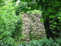
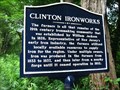
|  Clinton Ironworks - West Milford, NJ Clinton Ironworks - West Milford, NJ
in Iron Furnace Ruins The Clinton Ironworks furnace is on Clinton Road in West Milford NJ. It was operational from 1833 to 1837. The actual furnace is on NWCDC land and not open to the public, but the ruins can be viewed from the road. posted by: briansnat location: New Jersey date approved: 07/06/2008 last visited: 10/28/2017 |
 view gallery view galleryW4.8 km |  Clinton Ironworks - West Milford, NJ Clinton Ironworks - West Milford, NJ
in New Jersey Historical Markers A marker noting the location of the Clinton Ironworks, on Clinton Road in West Milford, N.J. posted by: briansnat location: New Jersey date approved: 07/06/2008 last visited: 10/28/2017 |
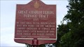 view gallery view galleryS5 km | Great Charlotteburg Furnace Tract - 1765 in New Jersey Historical Markers This Historica Marker is for a large land tract that was used prior during the American Revolution for iron production. The marker is located on Route 23 South at the entrance to Smoke Rise in Kinnelon, NJ. posted by: 79scouts location: New Jersey date approved: 07/03/2011 last visited: never |
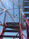 view gallery view galleryN5.5 km |  Bearfort Ridge Fire Tower Bearfort Ridge Fire Tower
in Look-Out Towers 68 foot fire tower on Newark (Pequannock) Watershed land posted by: weathernowcast location: New Jersey date approved: 07/12/2009 last visited: 05/21/2016 |
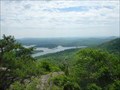
 view gallery view gallery E5.6 km E5.6 km
| Carris Hill in Scenic Overlooks A great view of the surrounding area from Carris Hill in Norvin Green State Forest. posted by: briansnat location: New Jersey date approved: 01/04/2008 last visited: never |
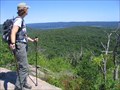
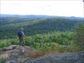
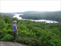
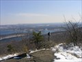 view gallery view galleryE5.6 km |  Wyanokie High Point Wyanokie High Point
in Mountain Summits While not exactly a 20,000 foot climb, or even close to the tallest peak in the area, Wyanokie High Point offers some of the finest views in the region.
On a clear day visitors will find a nearly 360 degree view with NYC visible to the east. posted by: briansnat location: New Jersey date approved: 12/21/2007 last visited: never |
 view gallery view galleryE5.6 km | Wyanokie High Point in Scenic Hikes A five mile hike to one of the finest overlooks in the region posted by: briansnat location: New Jersey date approved: 02/06/2008 last visited: 07/08/2007 |
 view gallery view gallery NE6.3 km NE6.3 km
| Overlook Rocks in Scenic Overlooks Overlook Rocks is a currently trailless overlook that is about 2 miles from any road. A hiking trail will be completed soon that will take you there. posted by: briansnat location: New Jersey date approved: 07/07/2008 last visited: never |
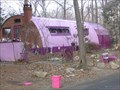 view gallery view galleryE6.3 km |  Snake Den Rd Quonset Snake Den Rd Quonset
in Quonset Huts This quonset hut is a private residence. The hut has an unusual color scheme with matching picnic tables, fences, garbage cans and even cars. posted by: briansnat location: New Jersey date approved: 01/13/2008 last visited: 04/14/2012 |
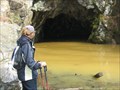 view gallery view galleryE6.4 km |  Blue Mine Blue Mine
in Mines Blue Mine, first opened in 1765, is in Norvin Green State Forest posted by: briansnat location: New Jersey date approved: 05/13/2008 last visited: 07/04/2009 |
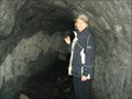 view gallery view galleryE6.6 km | Roomy Mine in Mines Roomy Mine is within the borders of Norvin Green State Forest. It was opened in the 1840's and worked until the 1880's. Iron ore was mined here and at nearby Blue Mine. posted by: briansnat location: New Jersey date approved: 01/08/2008 last visited: 04/14/2012 |
 view gallery view gallery SW6.9 km SW6.9 km
| Indian Cliffs in Scenic Overlooks Indian Cliffs are located along a hiking trail that skirts the eastern shore of Split Rock Reservoir. posted by: briansnat location: New Jersey date approved: 01/04/2008 last visited: never |
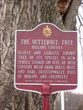 view gallery view gallerySE6.9 km |  The Butternut Tree - Kinnelon, NJ The Butternut Tree - Kinnelon, NJ
in Exceptional Trees This is the oldest and largest Butternut Tree in New Jersey posted by: briansnat location: New Jersey date approved: 01/24/2008 last visited: 02/11/2021 |
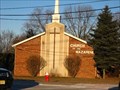 view gallery view gallerySE7.1 km |  Butler Community Church - Butler, NJ Butler Community Church - Butler, NJ
in Church of the Nazarene Butler Community Church - Church of the Nazarene posted by: briansnat location: New Jersey date approved: 02/20/2008 last visited: 07/31/2012 |
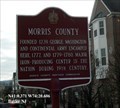 view gallery view gallerySE7.2 km | Morris County - Butler NJ in New Jersey Historical Markers Founded 1739. George Washington and Continental Army encamped here 1777, and 1779-1780. Major iron-producing center in the nation during the 19th Century. posted by: Don.Morfe location: New Jersey date approved: 05/03/2020 last visited: 10/14/2021 |
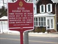 view gallery view gallerySE7.4 km | Butler Railroad Station, Butler NJ in New Jersey Historical Markers The Butler RR station was built in 1888 and served Butler and the surrounding area. Though the tracks are still used for freight, passenger service was discontinued long ago. The station is now a museum. posted by: briansnat location: New Jersey date approved: 02/15/2010 last visited: 03/08/2012 |
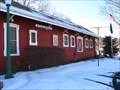 view gallery view gallerySE7.6 km |  Butler Museum Butler Museum
in History Museums The Butler Museum is in a converted train station and has a collection of artifacts related to local history. posted by: briansnat location: New Jersey date approved: 02/09/2010 last visited: 03/08/2012 |
|