 view gallery view gallery E12.2 km E12.2 km
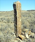
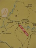
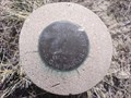
|   CO WY Hand Carved Stone State Line Monument CO WY Hand Carved Stone State Line Monument
in U.S. Historic Survey Stones and Monuments Hand Carved State Line Monument posted by:  cocoalminer cocoalminer location: Colorado date approved: 11/28/2007 last visited: never |
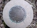
 view gallery view gallery W52 km W52 km
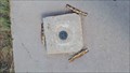
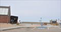
|  Benchmark MQ0481 Benchmark MQ0481
in U.S. Benchmarks Come stand in Colorado, Utah and Wyoming at the same time!!!
Please DO NOT post pictures of the nearby signage, that has answers to a seldom found Virtual Geocache here. posted by: animjason location: Colorado date approved: 10/07/2015 last visited: never |
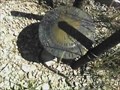 view gallery view galleryE53.9 km | Robber in U.S. Benchmarks This Benchmark is on top of North Flat Top, north of Baggs Wyoming. posted by: Jake81499 location: Wyoming date approved: 08/07/2007 last visited: never |
 view gallery view gallery SE65.2 km SE65.2 km
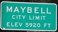
|  Maybell, Colorado (Western Approach) ~ Elevation 5920 Feet Maybell, Colorado (Western Approach) ~ Elevation 5920 Feet
in Elevation Signs This Elevation Sign is located on the south side of US Highway 40 at the western town limits of Maybell, Colorado. posted by: brwhiz location: Colorado date approved: 02/09/2013 last visited: never |
 view gallery view gallerySE65.2 km |  Maybell Country Maybell Country
in 'You Are Here' Maps You Are Here at the Maybell Country Historical Marker in the park on the north side of US Highway 40 in Maybell, Colorado. posted by: brwhiz location: Colorado date approved: 12/10/2012 last visited: never |
 view gallery view gallerySE65.3 km |  Maybell, Colorado 81640 Maybell, Colorado 81640
in U.S. Post Offices This Post Office is located at 200 Collum Street in Maybell, Colorado. posted by: brwhiz location: Colorado date approved: 10/24/2011 last visited: never |
 view gallery view gallery S65.7 km S65.7 km
|  "I Do" Fire ~ Maybell, Colorado "I Do" Fire ~ Maybell, Colorado
in Colorado Historical Markers This BLM Historical marker is located on the south side of US Highway 40 just west of County Road 143 about 5.5 miles west of Maybell, Colorado. posted by: brwhiz location: Colorado date approved: 02/07/2013 last visited: never |
 view gallery view galleryS65.7 km |  LARGEST -- Wildfire in Colorado Recorded History LARGEST -- Wildfire in Colorado Recorded History
in Superlatives The "I Do" Fire of 1988 was the largest wildfire in Colorado's recorded history at that time. posted by: brwhiz location: Colorado date approved: 02/06/2013 last visited: never |
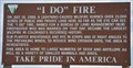 view gallery view galleryS65.7 km |  "I Do" Fire "I Do" Fire
in Famous Fires This BLM marker commemorating the largest (at that time) wildfire in Colorado history, is located on the south side of US Highway 40 just west of County Road 143 about 5.5 miles west of Maybell, Colorado. posted by: brwhiz location: Colorado date approved: 02/06/2013 last visited: never |
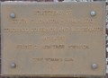
 view gallery view galleryS67.1 km | CDOT Right of Way Marker in U.S. Benchmarks CDOT right of way marker posted by: cocoalminer location: Colorado date approved: 04/24/2008 last visited: never |
 view gallery view galleryS67.1 km | CDOT right of way marker in U.S. Benchmarks Colorado State Highway R.O.W. marker posted by: cocoalminer location: Colorado date approved: 04/24/2008 last visited: never |
 view gallery view gallery N67.3 km N67.3 km
|  Mama Sage Mama Sage
in Flora and Fauna Information Signs This Wyoming Wildlife sign is located in the Bitter Creek Rest Area on the south side of eastbound Interstate Highway 80 east of Rock Springs, Wyoming. posted by: brwhiz location: Wyoming date approved: 09/28/2012 last visited: 07/03/2017 |
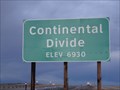 view gallery view galleryN67.3 km | Continental Divide - Elevation 6930 in Elevation Signs The Continental Divide crosses I-80 in several places in Wyoming, and here, the elevation is 6930 feet above sea level. posted by: QuarrellaDeVil location: Wyoming date approved: 10/03/2015 last visited: 05/14/2021 |
 view gallery view gallerySE69.2 km |  Johnson Homestead ~ Maybell, Colorado Johnson Homestead ~ Maybell, Colorado
in Lions Clubs International Markers The Craig Lions Club maintains the Johnson Homestaed and small accompanying park on the north side of US Highway 40 at Milepost 66, about 6 miles east of Maybell, Colorado. posted by: brwhiz location: Colorado date approved: 02/16/2013 last visited: never |
 view gallery view gallerySE69.2 km | The Johnson Homestead ~ Maybell, Colorado in Colorado Historical Markers This Historical Marker is mounted on a steel post at a turnout on the north side of US Highway 40 at Milepost 66, about 6 miles east of Maybell, Colorado. posted by: brwhiz location: Colorado date approved: 02/07/2013 last visited: never |
 view gallery view gallerySE69.2 km | Homestead of Edwin C. Johnson 1884-1970 ~ Maybell, Colorado in Colorado Historical Markers This Historical Marker is mounted on a red boulder on a concrete base at a turnout on the north side of US Highway 40 at Milepost 66, about 6 miles east of Maybell, Colorado. posted by: brwhiz location: Colorado date approved: 02/07/2013 last visited: never |
 view gallery view gallerySE75.6 km |  Juniper Hot Springs Juniper Hot Springs
in Hot Springs Juniper Hot Springs bubble up out of the ground outside of Lay, Colorado. posted by: Team Laxson location: Colorado date approved: 09/29/2008 last visited: 09/11/2013 |
 view gallery view gallerySE75.6 km |  Juniper Hot Springs House Juniper Hot Springs House
in Spring Houses The Juniper Hot Springs house is the only structure on the property remaining. posted by: Team Laxson location: Colorado date approved: 09/29/2008 last visited: never |
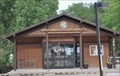
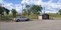 view gallery view galleryS76.3 km |  Elk Springs Rest Area Elk Springs Rest Area
in Highway Rest Areas The Highway Rest Area is located on the north side of US Highway 40 just east of County Road 14 on the eastern edge of the very small community of Elk Springs, Colorado. posted by: brwhiz location: Colorado date approved: 02/06/2013 last visited: never |
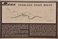
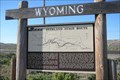 view gallery view galleryN76.4 km |  Overland Stage Route - Point of Rocks, Wyoming Overland Stage Route - Point of Rocks, Wyoming
in Wyoming Historical Markers The Overland Stage Route moved south to this area when the northern route was regularly attacked by Native Americans. posted by:  Hikenutty Hikenutty location: Wyoming date approved: 07/10/2007 last visited: 07/03/2017 |
 view gallery view galleryN76.4 km |  Overland/Cherokee Trail - Point of Rocks, Wyoming Overland/Cherokee Trail - Point of Rocks, Wyoming
in Wagon Roads and Trails In 1849 a group of whites and Cherokee Indians embarked on a journey from Arkansas to the gold mines of California. The trail they followed became known as the Cherokee Trail. posted by: Hikenutty location: Wyoming date approved: 07/11/2007 last visited: 07/03/2017 |
 view gallery view galleryN76.4 km | Overland Stage Route ~ Point of Rocks, Wyoming in Wagon Roads and Trails This Overland Stage Route Marker is located on the south side of Interstate Highway 80 at Exit 130. posted by: brwhiz location: Wyoming date approved: 10/02/2012 last visited: 07/03/2017 |
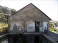
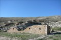 view gallery view gallery NW76.6 km NW76.6 km
|  Point of Rocks, Wyoming Point of Rocks, Wyoming
in American Guide Series Point of Rocks is nearly a ghost town at this point. The most well known feature of the town is its Overland Stage Station, built in 1861. posted by: Hikenutty location: Wyoming date approved: 08/17/2007 last visited: 11/08/2011 |
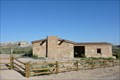 view gallery view galleryNW76.6 km | Almond Stage Station - Point of Rocks, Wyoming in American Guide Series This building was built in 1861 as a stagecoach station along the Overland Stage Line. It later served as a Pony Express station, a school and a residence. posted by: Hikenutty location: Wyoming date approved: 09/06/2007 last visited: 11/08/2011 |
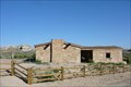 view gallery view galleryNW76.6 km |  Point of Rocks School - Point of Rocks, Wyoming Point of Rocks School - Point of Rocks, Wyoming
in Former Schools This building, originally a stagecoach stop, became a school in 1877 when the stagecoach line through the area was abandoned. posted by: Hikenutty location: Wyoming date approved: 07/11/2007 last visited: 11/08/2011 |
|