 view gallery view gallery NE5.6 km NE5.6 km
|   NGS Benchmark (KY3580) -Clinton, Ohio NGS Benchmark (KY3580) -Clinton, Ohio
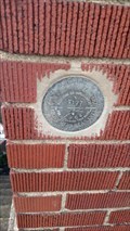
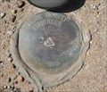
in U.S. Benchmarks NGS benchmark KY3580 set in a bridge abutment in the south side of Clinton, Ohio. posted by:  Knight2000 Knight2000 location: Ohio date approved: 04/15/2010 last visited: never |
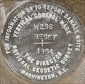
 view gallery view galleryNE5.6 km | NGS Vertical Control Mark (KY1640?) -Clinton, Ohio in U.S. Benchmarks Reset mark located on a railway bridge in Clinton, Ohio. posted by: Knight2000 location: Ohio date approved: 04/14/2010 last visited: never |
 view gallery view gallery E6.1 km E6.1 km
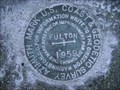
|  FULTON AZ MK - Lawrence Twp Stark County OH FULTON AZ MK - Lawrence Twp Stark County OH
in Azimuth Benchmarks This is the azimuth mark for station FULTON. The azimuth mark is in Lawrence Township, Stark County. posted by:  shorbird shorbird location: Ohio date approved: 05/08/2010 last visited: never |
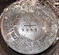
 view gallery view galleryNE6.3 km | KY1701 (T 177) - Clinton Summit County OH in U.S. Benchmarks US Coast & Geodetic Survey Benchmark in Clinton, OH posted by: Stachey Pete location: Ohio date approved: 02/28/2019 last visited: never |
 view gallery view gallery N6.6 km N6.6 km
| Wayne County Engineer GPS Monument, Doylestown Ohio in U.S. Benchmarks This benchmark is on a bridge located on County Highway 133 (Black Diamond Road) in Doylestown, Ohio. It is labeled "WAYNE COUNTY ENGINEER GPS MONUMENT". posted by: Knight2000 location: Ohio date approved: 04/12/2010 last visited: never |
 view gallery view galleryE6.6 km |  Canal Fulton United Methodist Church, Canal Fulton, OH Canal Fulton United Methodist Church, Canal Fulton, OH
in This Old Church United Methodist Church in Canal Fulton, OH posted by: prairie_hills_kid location: Ohio date approved: 09/09/2007 last visited: 08/22/2009 |
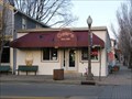 view gallery view galleryE7.1 km |  Osers Dairy and Deli Osers Dairy and Deli
in Ice Cream Parlors Osers Dairy and Deli is located on the main road in the quiet historic town of Canal Fulton, Ohio. posted by: miatabug location: Ohio date approved: 01/14/2008 last visited: never |
 view gallery view galleryE7.1 km |  Canal Fulton, Ohio 44614 Canal Fulton, Ohio 44614
in U.S. Post Offices Post office in the small historical town of Canal Fulton Ohio posted by: miatabug location: Ohio date approved: 01/14/2008 last visited: never |
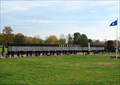 view gallery view galleryNE7.2 km |  Vietnam War Memorial, Ohio Veterans Memorial Park, Clinton, OH, USA Vietnam War Memorial, Ohio Veterans Memorial Park, Clinton, OH, USA
in Vietnam War Memorials Ohio State Vietnam War memorial containing the names of the 3,095 Ohioans who lost their lives in the war. posted by: HANSENNI location: Ohio date approved: 10/23/2009 last visited: never |
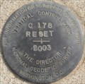
 view gallery view galleryNE7.4 km | NGS Triangulation Benchmark (KY2989) Clinton, Ohio in U.S. Benchmarks Triangulation station disk BAIER located in Clinton, Ohio. posted by: Knight2000 location: Ohio date approved: 04/11/2010 last visited: never |
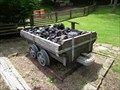 view gallery view galleryN7.6 km |  Coal Car - Corey Lowe - Doylestown, Ohio Coal Car - Corey Lowe - Doylestown, Ohio
in Eagle Scout Project Sites This 2008 Eagle Scout project is one of 13 Eagle Scout projects completed on the grounds of Rouges' Hollow by the members of Troop 123. posted by: miatabug location: Ohio date approved: 05/20/2010 last visited: never |
 view gallery view galleryN7.6 km | Mill Bridge - Josh Burton - Doylestown, Ohio in Eagle Scout Project Sites This 2002 Eagle Scout project is one of 13 Eagle Scout projects completed on the grounds of Rouges' Hollow by the members of Troop 123. posted by: miatabug location: Ohio date approved: 05/20/2010 last visited: never |
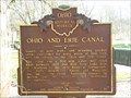 view gallery view galleryE8 km |  Ohio and Erie Canal (1-76) Ohio and Erie Canal (1-76)
in Ohio Historical Markers Historical marker for the Ohio and Erie Canal located in the town of Canal Fulton. posted by: miatabug location: Ohio date approved: 01/18/2008 last visited: 09/15/2018 |
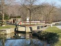 view gallery view galleryE8 km |  Ohio and Erie Canal Lock #4 Ohio and Erie Canal Lock #4
in Waterway Locks, Planes and Lifts Lock #4 is located near the hsitoric town of Canal Fulton, Ohio. posted by: miatabug location: Ohio date approved: 01/19/2008 last visited: 09/15/2018 |
 view gallery view gallery SW8 km SW8 km
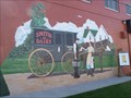
|  Smith Dairy murals - Orrville, Ohio Smith Dairy murals - Orrville, Ohio
in Murals Murals depicting the history of Smith Dairy. posted by: buffalohiker location: Ohio date approved: 10/19/2009 last visited: 10/11/2009 |
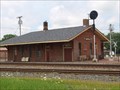 view gallery view gallerySW8.4 km |  Union Depot - Orrville, Ohio Union Depot - Orrville, Ohio
in Train Stations/Depots The historic Orrville Union Depot, constructed in
1868 at the crossing of the Cleveland, Akron & Columbus
and Pittsburgh, Ft. Wayne & Chicago Railroads,
serves as the headquarters of Orrville Railroad Heritage Society. posted by: buffalohiker location: Ohio date approved: 11/11/2015 last visited: 07/18/2015 |
 view gallery view gallery S8.4 km S8.4 km
| Dalton, OH 44618 in U.S. Post Offices Post office in Dalton, Wayne County, Ohio. posted by: bitmapped location: Ohio date approved: 08/05/2008 last visited: 11/13/2004 |
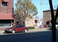
 view gallery view galleryS8.4 km |  Eagle Hotel & Tavern - 115 E Main St, Dalton, Ohio Eagle Hotel & Tavern - 115 E Main St, Dalton, Ohio
in Lincoln Highway The Eagle Hotel, built in 1821, is found at 115 E Main St in Dalton, Ohio on the Lincoln Highway. posted by: buffalohiker location: Ohio date approved: 09/07/2016 last visited: 03/06/2021 |
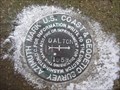 view gallery view galleryS8.7 km | CC9818(DALTON AZ MK) - Sugar Creek Twp Wayne County OH in Azimuth Benchmarks This is the azimuth mark for USC&GS triangulation station DALTON, in Sugar Creek Township, Wayne County. posted by: shorbird location: Ohio date approved: 12/08/2014 last visited: never |
 view gallery view gallery NW9 km NW9 km
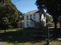
|  Ezekiel Zimmerman octagon house (1883) - Marshallville, Ohio Ezekiel Zimmerman octagon house (1883) - Marshallville, Ohio
in Octagon Buildings Ezekiel Zimmerman octagon house - 10095 Wadsworth Rd (State Route 57), Marshallville, Ohio built 1882-1883. posted by: buffalohiker location: Ohio date approved: 02/15/2016 last visited: 02/06/2016 |
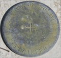 view gallery view galleryNE9.8 km | County of Summit Engineer BM -Clinton, Ohio in U.S. Benchmarks Benchmark on the west bridge abutment of the bridge over the Tuscarawas River on Center Road in Clinton, Ohio. posted by: Knight2000 location: Ohio date approved: 04/11/2010 last visited: never |
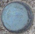
 view gallery view galleryNW9.8 km | NGS Benchmark (KY1711) Doylestown, Ohio in U.S. Benchmarks National Geodetic Survey benchmark in Doylestown, Ohio that is destroyed per NGS guidelines. posted by: Knight2000 location: Ohio date approved: 04/14/2010 last visited: never |
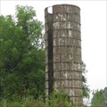 view gallery view galleryNW9.8 km |  Easton Road - Easton Ohio Easton Road - Easton Ohio
in Solitary Silos This silo sits alone in a field. posted by: lp5324 location: Ohio date approved: 09/13/2008 last visited: never |
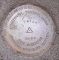
 view gallery view galleryNE12.2 km | NGS Azimuth Benchmark (KY2996) Clinton, Ohio in U.S. Benchmarks Azimuth benchmark located along Johns Road in Clinton, Ohio. posted by: Knight2000 location: Ohio date approved: 04/11/2010 last visited: never |
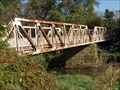 view gallery view galleryE12.7 km |  Crystal Springs Pratt riveted pony - Massillon, Ohio Crystal Springs Pratt riveted pony - Massillon, Ohio
in Truss Bridges Two-span pony truss bridge over Tuscarawas River on Riverside Avenue/High Mill Avenue. Built 1914; rehabilitated 1990; closed to traffic in 1995. posted by: buffalohiker location: Ohio date approved: 11/28/2014 last visited: 10/08/2014 |
|