 view gallery view gallery NE7.4 km NE7.4 km
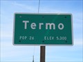
|   Termo, CA (Southern Approach) - 5300' Termo, CA (Southern Approach) - 5300'
in Elevation Signs The sign is located at the southern approach to Termo along Highway 395. posted by:  WR7X WR7X location: California date approved: 03/27/2014 last visited: never |
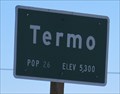 view gallery view galleryNE7.4 km | Termo, CA (Northern Approach) - 5300' in Elevation Signs The sign is located at the northern approach to Termo on Highway 395. posted by: WR7X location: California date approved: 03/27/2014 last visited: never |
 view gallery view gallery E13.4 km E13.4 km
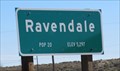
| Ravendale, CA (Northern Approach) - 5297' in Elevation Signs The sign is located at the northern approach to Ravendale on Highway 395. posted by: WR7X location: California date approved: 03/21/2014 last visited: never |
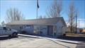 view gallery view galleryE13.4 km |  Ravendale, CA 96123 Ravendale, CA 96123
in U.S. Post Offices This post office resides at the small community of Ravendale. posted by: NW_history_buff location: California date approved: 12/10/2016 last visited: never |
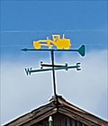 view gallery view galleryE13.4 km |  Road Grader Weathervane - Ravendale, CA Road Grader Weathervane - Ravendale, CA
in Unique Weathervanes This unique weathervane is located atop a work shed in Ravendale. posted by: NW_history_buff location: California date approved: 12/16/2016 last visited: never |
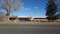 view gallery view galleryE13.5 km |  Ravendale Christian Church - Ravendale, CA Ravendale Christian Church - Ravendale, CA
in Religious Buildings Multifarious This community church was a former motel. posted by: NW_history_buff location: California date approved: 11/27/2016 last visited: never |
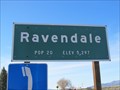 view gallery view galleryE13.7 km | Ravendale, CA (Southern Approach) - 5297' in Elevation Signs The sign is located at the southern approach to Ravendale on Highway 395. posted by: WR7X location: California date approved: 03/21/2014 last visited: never |
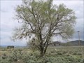 view gallery view galleryE15 km |  Shoe Tree - Ravendale, CA Shoe Tree - Ravendale, CA
in Shoe Trees Shoe tree just south of Ravendale, CA on Hwy 395 posted by:  fishingwishing fishingwishing location: California date approved: 05/29/2008 last visited: 05/29/2011 |
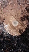
 view gallery view gallery SW17.9 km SW17.9 km
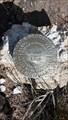
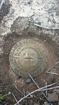
|  LT0196 - USC&GS 'N 257' BM - Lassen County, CA LT0196 - USC&GS 'N 257' BM - Lassen County, CA
in U.S. Benchmarks This NGS benchmark is located just off Highway 139 in Lassen County. posted by: NW_history_buff location: California date approved: 05/30/2017 last visited: never |
 view gallery view gallery W18 km W18 km
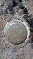
| USGS '22C 1933' BM - Lassen County, CA in U.S. Benchmarks This benchmark is located NE of Highway 139 on Cleghorn Road (inaccessible via vehicle). posted by: NW_history_buff location: California date approved: 05/30/2017 last visited: never |
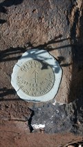
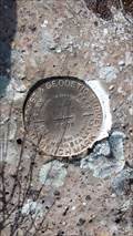 view gallery view gallerySW19.3 km | LT0195 - USC&GS 'P 257 RESET 1970' BM - Lassen County, CA in U.S. Benchmarks This NGS benchmark is located just off Highway 139 in Lassen County. posted by: NW_history_buff location: California date approved: 05/30/2017 last visited: never |
 view gallery view galleryW20.4 km | LT0606 - CDH 'EWE CADH 1968 AZ MK' Azimuth Mark - Lassen County, CA in U.S. Benchmarks This NGS azimuth mark is located west of Highway 13 in Lassen County. posted by: NW_history_buff location: California date approved: 05/30/2017 last visited: never |
 view gallery view gallerySW22.7 km |  Joint Hwy No. 14 FAS Route 988 - Lassen County, CA Joint Hwy No. 14 FAS Route 988 - Lassen County, CA
in Signs of History This roadside marker sits along Hwy 139 near Eagle Lake in Lassen County, CA. posted by: NW_history_buff location: California date approved: 01/16/2014 last visited: never |
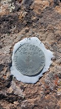
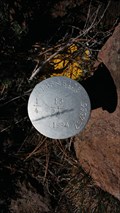
 view gallery view gallerySW23 km | LT0191 - USC&GS 'R 257' BM - Lassen County, CA in U.S. Benchmarks This NGS benchmark is located just off Highway 139 in Lassen County. posted by: NW_history_buff location: California date approved: 05/30/2017 last visited: never |
 view gallery view gallery SE23.2 km SE23.2 km
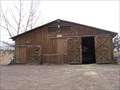
|  Spanish Springs Ranch Stable - Susanville, CA Spanish Springs Ranch Stable - Susanville, CA
in Barns Typical western style stable and tack barn located on this dude ranch in California cowboy country near Susanville. posted by: fishingwishing location: California date approved: 12/28/2008 last visited: never |
 view gallery view gallery NW23.3 km NW23.3 km
| LT0597 - CDH 'SAID CADH 1968 AZ MK' Azimuth Mark - Lassen County, CA in U.S. Benchmarks This NGS azimuth mark is located just off Highway 139. posted by: NW_history_buff location: California date approved: 05/30/2017 last visited: never |
 view gallery view gallerySW24.8 km | LT0583 - USC&GS 'LITTER' Station Mark - Lassen County, CA in U.S. Benchmarks This NGS station mark is located just off Highway 139 in Lassen County. posted by: NW_history_buff location: California date approved: 05/30/2017 last visited: never |
 view gallery view gallerySW24.8 km | LT0583 - USC&GS 'LITTER' Reference Mark - Lassen County, CA in U.S. Benchmarks This NGS reference mark is located just off Highway 139 in Lassen County. posted by: NW_history_buff location: California date approved: 05/30/2017 last visited: never |
 view gallery view galleryNW25.3 km | T36N R10E S13 S24 1/4 Section - Lassen County, CA in U.S. Benchmarks This 1/4 section corner is located close to Highway 139 in Lassen County. posted by: NW_history_buff location: California date approved: 05/30/2017 last visited: never |
 view gallery view galleryNW25.3 km |  T36N R10E S13 S24 1/4 Section - Lassen County, CA T36N R10E S13 S24 1/4 Section - Lassen County, CA
in Public Land Survey Marks This 1/4 section corner is located close to Highway 139 in Lassen County. posted by: NW_history_buff location: California date approved: 05/28/2017 last visited: never |
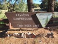 view gallery view gallerySE25.9 km |  Ramhorn Springs Campground - CA Ramhorn Springs Campground - CA
in Campgrounds A small, off the beaten path campground north of Susanville, CA posted by: ChapterhouseInc location: California date approved: 06/30/2013 last visited: 06/28/2013 |
 view gallery view gallery N26.1 km N26.1 km
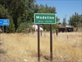
|  Madeline, California - Pop. 60 Madeline, California - Pop. 60
in Population Signs Stopped here and sent a postcard to my daughter of the same name (Madeline) posted by: tbarhunt location: California date approved: 11/05/2009 last visited: 03/14/2011 |
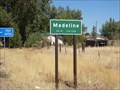
 view gallery view galleryN26.2 km | Madeline, California - Elev. 5320' in Elevation Signs City sign with population and elevation information along Highway 395. posted by: Robert04 location: California date approved: 12/22/2011 last visited: 03/20/2014 |
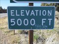 view gallery view gallerySE29.3 km | Highway 395 - Ravendale, CA - 5000' in Elevation Signs The 5000' contour is marked near the rest area 12 miles south of Ravendale, California. posted by: WR7X location: California date approved: 03/21/2014 last visited: never |
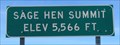 view gallery view galleryN30.9 km | Sage Hen Summit - Madeline, CA - 5566' in Elevation Signs The sign is located on Highway 395 about 3 miles north of Madeline. posted by: WR7X location: California date approved: 03/27/2014 last visited: never |
|