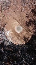
 view gallery view gallery E11.1 km E11.1 km
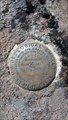
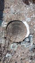
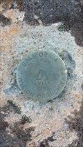
|   USGS '22C 1933' BM - Lassen County, CA USGS '22C 1933' BM - Lassen County, CA
in U.S. Benchmarks This benchmark is located NE of Highway 139 on Cleghorn Road (inaccessible via vehicle). posted by:  NW_history_buff NW_history_buff location: California date approved: 05/30/2017 last visited: never |
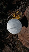
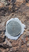 view gallery view gallery NE11.6 km NE11.6 km
| LT0606 - CDH 'EWE CADH 1968 AZ MK' Azimuth Mark - Lassen County, CA in U.S. Benchmarks This NGS azimuth mark is located west of Highway 13 in Lassen County. posted by: NW_history_buff location: California date approved: 05/30/2017 last visited: never |
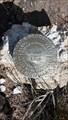 view gallery view gallery SE17.4 km SE17.4 km
| LT0196 - USC&GS 'N 257' BM - Lassen County, CA in U.S. Benchmarks This NGS benchmark is located just off Highway 139 in Lassen County. posted by: NW_history_buff location: California date approved: 05/30/2017 last visited: never |
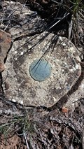 view gallery view galleryNE19.2 km | LT0597 - CDH 'SAID CADH 1968 AZ MK' Azimuth Mark - Lassen County, CA in U.S. Benchmarks This NGS azimuth mark is located just off Highway 139. posted by: NW_history_buff location: California date approved: 05/30/2017 last visited: never |
 view gallery view gallerySE19.8 km | LT0195 - USC&GS 'P 257 RESET 1970' BM - Lassen County, CA in U.S. Benchmarks This NGS benchmark is located just off Highway 139 in Lassen County. posted by: NW_history_buff location: California date approved: 05/30/2017 last visited: never |
 view gallery view gallery N20.1 km N20.1 km
| T36N R10E S13 S24 1/4 Section - Lassen County, CA in U.S. Benchmarks This 1/4 section corner is located close to Highway 139 in Lassen County. posted by: NW_history_buff location: California date approved: 05/30/2017 last visited: never |
 view gallery view galleryN20.1 km |  T36N R10E S13 S24 1/4 Section - Lassen County, CA T36N R10E S13 S24 1/4 Section - Lassen County, CA
in Public Land Survey Marks This 1/4 section corner is located close to Highway 139 in Lassen County. posted by: NW_history_buff location: California date approved: 05/28/2017 last visited: never |
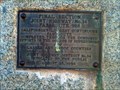 view gallery view gallerySE22.7 km |  Joint Hwy No. 14 FAS Route 988 - Lassen County, CA Joint Hwy No. 14 FAS Route 988 - Lassen County, CA
in Signs of History This roadside marker sits along Hwy 139 near Eagle Lake in Lassen County, CA. posted by: NW_history_buff location: California date approved: 01/16/2014 last visited: never |
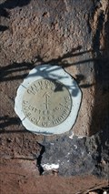
 view gallery view gallerySE23.3 km | LT0191 - USC&GS 'R 257' BM - Lassen County, CA in U.S. Benchmarks This NGS benchmark is located just off Highway 139 in Lassen County. posted by: NW_history_buff location: California date approved: 05/30/2017 last visited: never |
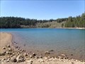 view gallery view gallery SW23.3 km SW23.3 km
|  Crater Lake - California Crater Lake - California
in Natural Lakes Crater Lake in Lassen National Forest, California. posted by: Volcanoguy location: California date approved: 11/07/2013 last visited: 09/15/2013 |
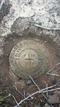
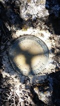
 view gallery view gallerySE25.6 km | LT0583 - USC&GS 'LITTER' Station Mark - Lassen County, CA in U.S. Benchmarks This NGS station mark is located just off Highway 139 in Lassen County. posted by: NW_history_buff location: California date approved: 05/30/2017 last visited: never |
 view gallery view gallerySE25.6 km | LT0583 - USC&GS 'LITTER' Reference Mark - Lassen County, CA in U.S. Benchmarks This NGS reference mark is located just off Highway 139 in Lassen County. posted by: NW_history_buff location: California date approved: 05/30/2017 last visited: never |
 view gallery view galleryN26.7 km | MW0185 - USDA '4893.4 USFS' BM - Lassen County, CA in U.S. Benchmarks This NGS benchmark is located south of Highway 139 in Lassen County. posted by: NW_history_buff location: California date approved: 05/30/2017 last visited: never |
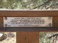 view gallery view gallerySW28.8 km | Lassen Trail--Pine Creek Valley - California in Signs of History Lassen Trail history marker near CA Hwy 44 at Pine Creek Valley. posted by: Volcanoguy location: California date approved: 11/08/2013 last visited: 09/15/2013 |
 view gallery view gallerySW29.3 km |  Bogard Rest Area - California Bogard Rest Area - California
in Highway Rest Areas The Bogard Rest Area on CA Hwy 44. posted by: Volcanoguy location: California date approved: 11/08/2013 last visited: 09/15/2013 |
 view gallery view galleryN29.3 km | MW0788 - USC&GS 'AVILA' Station Mark - Lassen County, CA in U.S. Benchmarks This NGS station mark is located just off Highway 139. posted by: NW_history_buff location: California date approved: 05/30/2017 last visited: never |
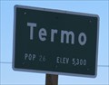 view gallery view galleryE34.6 km |  Termo, CA (Northern Approach) - 5300' Termo, CA (Northern Approach) - 5300'
in Elevation Signs The sign is located at the northern approach to Termo on Highway 395. posted by: WR7X location: California date approved: 03/27/2014 last visited: never |
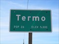 view gallery view galleryE34.6 km | Termo, CA (Southern Approach) - 5300' in Elevation Signs The sign is located at the southern approach to Termo along Highway 395. posted by: WR7X location: California date approved: 03/27/2014 last visited: never |
 view gallery view gallerySW39.4 km | Nobles Trail--Butte Creek Meadow - California in Signs of History Nobles Trail history marker near CA Hwy 44 and Butte Creek. posted by: Volcanoguy location: California date approved: 11/08/2013 last visited: 09/15/2013 |
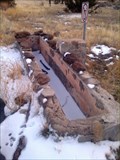 view gallery view gallerySE40.9 km |  Jacks Valley Water Trough - Lassen County, CA Jacks Valley Water Trough - Lassen County, CA
in Historic Upping Stones, Hitching Posts, and Carriage Blocks This E Clampus Vitus historical marker sits just off Hwy 139 in Lassen County, CA and claims the nearby watering trough as the only one of its kind in northeastern California. posted by: NW_history_buff location: California date approved: 07/07/2014 last visited: never |
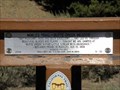
 view gallery view gallerySE40.9 km |  Jacks Valley, CA Jacks Valley, CA
in E Clampus Vitus Historical Markers This E Clampus Vitus historical marker sits just off Hwy 139 in Lassen County, CA. posted by: NW_history_buff location: California date approved: 12/27/2013 last visited: never |
 view gallery view gallerySE40.9 km |  ONLY -- Water Trough of its Kind in Northeastern California ONLY -- Water Trough of its Kind in Northeastern California
in Superlatives This E Clampus Vitus historical marker sits just off Hwy 139 in Lassen County, CA and claims the nearby watering trough as the only one of its kind in northeastern California. posted by: NW_history_buff location: California date approved: 12/27/2013 last visited: never |
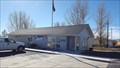 view gallery view galleryE41.2 km |  Ravendale, CA 96123 Ravendale, CA 96123
in U.S. Post Offices This post office resides at the small community of Ravendale. posted by: NW_history_buff location: California date approved: 12/10/2016 last visited: never |
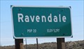 view gallery view galleryE41.2 km | Ravendale, CA (Northern Approach) - 5297' in Elevation Signs The sign is located at the northern approach to Ravendale on Highway 395. posted by: WR7X location: California date approved: 03/21/2014 last visited: never |
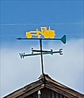 view gallery view galleryE41.2 km |  Road Grader Weathervane - Ravendale, CA Road Grader Weathervane - Ravendale, CA
in Unique Weathervanes This unique weathervane is located atop a work shed in Ravendale. posted by: NW_history_buff location: California date approved: 12/16/2016 last visited: never |
|