 view gallery view gallery S5 km S5 km
|   222 - Franklin Twp Wayne County OH 222 - Franklin Twp Wayne County OH
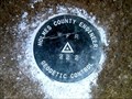
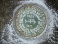
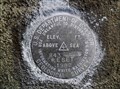
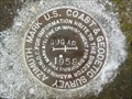
in U.S. Benchmarks This is a Holmes County survey disk in Franklin Township, Wayne County. posted by:  shorbird shorbird location: Ohio date approved: 04/01/2015 last visited: never |
 view gallery view gallery N7.1 km N7.1 km
|  CD1994(MYERS AZ MK) - Wooster Twp Wayne County OH CD1994(MYERS AZ MK) - Wooster Twp Wayne County OH
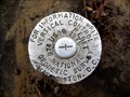
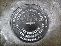
in Azimuth Benchmarks This is the azimuth mark for USC&GS triangulation station MYERS, in Wooster Township, Wayne County. posted by: shorbird location: Ohio date approved: 01/06/2015 last visited: never |
 view gallery view gallery SE7.4 km SE7.4 km
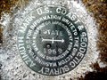
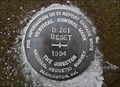
| 974 RESET - Fredericksburg OH in U.S. Benchmarks This is National Geodetic Survey vertical control mark in Fredericksburg, Wayne County. posted by: shorbird location: Ohio date approved: 04/04/2015 last visited: never |
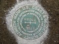
 view gallery view galleryN7.7 km | CD2176(STATE AZ MK) - Wooster Twp Wayne County OH in Azimuth Benchmarks This is the azimuth mark for USC&GS triangulation station STATE 2, in Wooster Township, Wayne County. posted by: shorbird location: Ohio date approved: 01/06/2015 last visited: never |
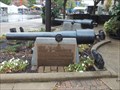 view gallery view galleryN9.5 km |  Pensacola Parrott Guns Pensacola Parrott Guns
in U.S. Civil War Sites The site consists of two Parrott Guns from the Civil War Battleship the Pensacola. posted by:  redwolf5 redwolf5 location: Ohio date approved: 12/04/2016 last visited: never |
 view gallery view galleryN9.5 km |  Wayne County Courthouse - Wooster Ohio Wayne County Courthouse - Wooster Ohio
in Courthouses Wayne County Courthouse - 107 W Liberty St, Wooster Ohio posted by: buffalohiker location: Ohio date approved: 02/08/2016 last visited: 09/17/2016 |
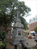 view gallery view galleryN9.7 km | Wayne County Civil War Memorial in U.S. Civil War Sites This monument depicts a Union soldier with pack and gun at parade rest. The monument faces the courthouse in downtown Wooster, Ohio. posted by: redwolf5 location: Ohio date approved: 09/18/2016 last visited: never |
 view gallery view galleryN9.7 km | CREST AZ MK - Ohio in Azimuth Benchmarks This is the azimuth mark for triangulation station CREST, in Wooster Township, Wayne County. posted by: shorbird location: Ohio date approved: 07/03/2010 last visited: never |
 view gallery view galleryS9.8 km | D 261 RESET 1994 - Prairie Twp Holmes County OH in U.S. Benchmarks This is an NGS Vertical Control Mark disk set in the southwest wing wall of a bridge in Prairie Township, Holmes County. posted by: shorbird location: Ohio date approved: 12/23/2011 last visited: never |
 view gallery view gallery W10.9 km W10.9 km
|  Brown's Lake Bog Brown's Lake Bog
in U.S. National Natural Landmarks A Kettle Lake, Bogg and Glacier Kame open to the public. posted by: Team RAGAR location: Ohio date approved: 06/11/2012 last visited: 03/23/2019 |
 view gallery view galleryS11.1 km | 843 RESET 1982 in U.S. Benchmarks This is a USGS survey disk set in a bridge abutment in Prairie Township, Holmes County. posted by: shorbird location: Ohio date approved: 12/23/2011 last visited: never |
 view gallery view gallerySE11.4 km | KERR AZ MK - Ohio in Azimuth Benchmarks This is the azimuth mark for triangulation station KERR, in Salt Creek Township, Holmes County. posted by: shorbird location: Ohio date approved: 12/05/2011 last visited: never |
 view gallery view gallery NE12.2 km NE12.2 km
| CD1867(HODGE AZ MK) - East Union Twp Wayne County OH in Azimuth Benchmarks This is the azimuth mark for USC&GS triangulation station HODGE. It is in East Union Township, Wayne County. posted by: shorbird location: Ohio date approved: 12/08/2014 last visited: never |
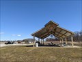 view gallery view galleryN13.7 km |  Oak Hill Park Pavilion - Wooster, OH Oak Hill Park Pavilion - Wooster, OH
in Rotary International Markers A large Rotary Club gear wheel on a pavilion in Wooster, OH. posted by: TyroneShoelaces location: Ohio date approved: 10/07/2021 last visited: 10/09/2021 |
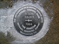 view gallery view galleryS14.8 km | V 275 RESET 1994 - Hardy Twp Holmes County OH in U.S. Benchmarks This is vertical control mark V 275 RESET 1994, set in a bridge in Hardy Township, Holmes County. posted by: shorbird location: Ohio date approved: 12/23/2011 last visited: never |
 view gallery view galleryNE14.8 km | CD2186(SUGAR AZ MK) - East Union Twp Wayne County OH in Azimuth Benchmarks This is the azimuth mark for USC&GS triangulation station SUGAR, in East Union Township, Wayne County. posted by: shorbird location: Ohio date approved: 12/09/2014 last visited: never |
 view gallery view gallerySE15 km | Y 279 RESET 2000 - Salt Creek Twp Holmes County OH in U.S. Benchmarks This is a National Geodetic Survey vertical control mark, set in 2000 to replace the mark reset in 1975(KY2891), in Salt Creek Township, Holmes County Ohio. This mark has no PID. posted by: shorbird location: Ohio date approved: 12/01/2011 last visited: never |
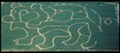
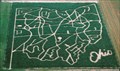 view gallery view galleryN15.1 km |  Ohio Corn Maze - Ramseyer Farm Ohio Corn Maze - Ramseyer Farm
in Outdoor Mazes Located in Wayne County Ohio each year Ramseyer Farm offers two Corm Mazes, one in the shape of the State of Ohio and a mystery maze posted by: 5hills location: Ohio date approved: 11/18/2009 last visited: never |
 view gallery view gallery E15.9 km E15.9 km
| WEAVER AZ MK - Ohio in Azimuth Benchmarks This is the azimuth mark for triangulation station WEAVER, in Salt Creek Township, Holmes County. It is in poor condition, with the disk missing and the stem intact. posted by: shorbird location: Ohio date approved: 12/05/2011 last visited: never |
 view gallery view galleryS16.7 km |  Barn Inn Bed and Breakfast - Millersburg, Ohio Barn Inn Bed and Breakfast - Millersburg, Ohio
in Bed and Breakfast The Barn Inn is located smack in the middle of Ohio's Amish Country.
From the moment you walk through the door the owners make you feel like family. posted by: BigPapaMark location: Ohio date approved: 12/28/2008 last visited: 01/02/2022 |
 view gallery view galleryS16.9 km |  Amish Nine-Patch Wall Quilt, Millersburg, OH Amish Nine-Patch Wall Quilt, Millersburg, OH
in Painted Barn Quilts Located at The Barn Inn Bed & Breakfast in Holmes County- 6838 County Road 203, Millersburg, OH posted by: 5hills location: Ohio date approved: 12/31/2008 last visited: 09/11/2014 |
 view gallery view gallerySE17.1 km |  Green Shuttered Barn - Holmes County, OH Green Shuttered Barn - Holmes County, OH
in Barns This is a unique barn in the Amish country of Ohio, very striking with its green shutters, located on Route 201 in rural Holmes County south of Fryburg, Ohio. posted by: silverquill location: Ohio date approved: 04/07/2008 last visited: never |
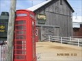 view gallery view galleryE17.1 km |  Lehman's Hardware Amish Phone Booth Lehman's Hardware Amish Phone Booth
in Red Telephone Boxes Kidron, Ohio posted by: Team RAGAR location: Ohio date approved: 04/05/2008 last visited: 04/27/2011 |
 view gallery view galleryE17.1 km |  Lehmans Penny Smasher, Kidron Ohio Lehmans Penny Smasher, Kidron Ohio
in Penny Smashers Lehmans Hardware Store posted by: Team RAGAR location: Ohio date approved: 08/17/2009 last visited: 02/28/2013 |
 view gallery view galleryN17.1 km | The Barn at Smithville in Outdoor Mazes Located at The Barn restaurant in Smithville, Oh. posted by: 5hills location: Ohio date approved: 11/18/2009 last visited: never |
|