 view gallery view gallery N6.4 km N6.4 km
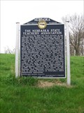
|   Nebraska State Teachers' Association # 417 Nebraska State Teachers' Association # 417
in Nebraska Historical Markers Historical marker in the town of Brownville. posted by:  Biker Ozzy Biker Ozzy location: Nebraska date approved: 04/27/2009 last visited: never |
 view gallery view galleryN6.4 km | Lewis and Clark Campsite: July 15, 1804 in Nebraska Historical Markers Historical marker in the Brownville State Recreation Area in Brownville, Nebraska.
posted by:  BruceS BruceS location: Nebraska date approved: 12/08/2008 last visited: 06/08/2014 |
 view gallery view galleryN6.4 km |  Lewis and Clark Campsite: July 15, 1804 Lewis and Clark Campsite: July 15, 1804
in Lewis and Clark Trail Historical marker in the Brownville State Recreation Area in Brownville, Nebraska. posted by: BruceS location: Nebraska date approved: 12/08/2008 last visited: 06/08/2014 |
 view gallery view galleryN6.6 km |  CAPTAIN MERIWETHER LEWIS (dredge) - Brownville, Nebraska CAPTAIN MERIWETHER LEWIS (dredge) - Brownville, Nebraska
in Landlocked Boats Historic Missouri River dredge boat operated by the U.S. Army Corps of Engineers, now a museum, located in Brownville, Nebraska, listed as a National Historic Landmark. posted by: BruceS location: Nebraska date approved: 12/21/2008 last visited: 06/01/2021 |
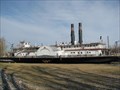 view gallery view galleryN6.6 km | ") CAPTAIN MERIWETHER LEWIS (dredge) - Brownville, Nebraska CAPTAIN MERIWETHER LEWIS (dredge) - Brownville, Nebraska
in Military Ships and Submarines (Decommissioned) Historic Missouri River dredge boat operated by the U.S. Army Corps of Engineers, now a museum, located in Brownville, Nebraska, listed as a National Historic Landmark. posted by: BruceS location: Nebraska date approved: 12/07/2008 last visited: 07/01/2021 |
 view gallery view galleryN6.6 km |  CAPTAIN MERIWETHER LEWIS (dredge) - Brownville, Nebraska CAPTAIN MERIWETHER LEWIS (dredge) - Brownville, Nebraska
in U.S. National Register of Historic Places Historic Missouri River dredge boat operated by the U.S. Army Corps of Engineers, now a museum, located in Brownville, Nebraska, listed as a National Historic Landmark.
posted by: BruceS location: Nebraska date approved: 12/07/2008 last visited: 06/08/2014 |
 view gallery view galleryN6.6 km |  Captain Meriwether Lewis (dustpan dredge) - Brownville, Nebraska Captain Meriwether Lewis (dustpan dredge) - Brownville, Nebraska
in Wikipedia Entries Historic Missouri River dredge boat operated by the U.S. Army Corps of Engineers, now a museum, located in Brownville, Nebraska, listed as a National Historic Landmark. posted by: BruceS location: Nebraska date approved: 02/16/2010 last visited: 06/08/2014 |
 view gallery view galleryN6.6 km |  Burlington Caboose - Brownville, Nebraska Burlington Caboose - Brownville, Nebraska
in Train Cabooses Caboose located next to old depot in Brownville, Nebraska.
posted by: BruceS location: Nebraska date approved: 12/07/2008 last visited: 05/17/2024 |
 view gallery view galleryN6.6 km |  Brownville Depot - Brownville, Nebraska Brownville Depot - Brownville, Nebraska
in Train Stations/Depots Railroad passenger depot in Brownville, Nebraska.
posted by: BruceS location: Nebraska date approved: 12/10/2008 last visited: 09/06/2020 |
 view gallery view galleryN6.6 km | Brownville # 159 in Nebraska Historical Markers Brownville Historical marker. posted by: Biker Ozzy location: Nebraska date approved: 04/27/2009 last visited: 09/06/2020 |
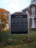 view gallery view galleryN6.8 km | Muir House, Marker # 52 in Nebraska Historical Markers Historical House. posted by: Biker Ozzy location: Nebraska date approved: 04/27/2009 last visited: never |
 view gallery view galleryN6.8 km |  Brownville Bridge - Brownville, Nebraska Brownville Bridge - Brownville, Nebraska
in Truss Bridges Truss bridge spanning the Missouri River between Brownville, Nebraska and Atchison County, Missouri. posted by: BruceS location: Nebraska date approved: 12/08/2008 last visited: 06/08/2014 |
 view gallery view galleryN6.8 km | Brownville Bridge - Brownville, Nebraska in U.S. National Register of Historic Places Truss bridge spanning the Missouri River between Brownville, Nebraska and Atchison County, Missouri.
posted by: BruceS location: Nebraska date approved: 12/07/2008 last visited: 06/08/2014 |
 view gallery view galleryN6.9 km |  NE/MO on US 136 NE/MO on US 136
in Border Crossings Located near I29 and Brownville, NE. posted by:  ChapterhouseInc ChapterhouseInc location: Nebraska date approved: 01/25/2014 last visited: 06/08/2014 |
 view gallery view gallery NE12.2 km NE12.2 km
|  Missouri Welcome Center - I-29 South Rock Port Rest Area Missouri Welcome Center - I-29 South Rock Port Rest Area
in Tourist Information Centers - Visitor Centers Welcome Center located at rest area on I-29 Southbound near Rock Port, Missouri. posted by: BruceS location: Missouri date approved: 09/04/2006 last visited: 02/07/2014 |
 view gallery view galleryNE12.2 km |  I-29 Southbound Rock Port Rest Area I-29 Southbound Rock Port Rest Area
in Highway Rest Areas Rest area and Missouri Welcome Center located on I-29 Southbound near Rock Port, Missouri. posted by: BruceS location: Missouri date approved: 09/04/2006 last visited: 02/07/2014 |
 view gallery view galleryNE12.2 km |  I-29 Southbound Rock Port Rest Area - Missouri I-29 Southbound Rock Port Rest Area - Missouri
in Blue Star Memorial Highway Markers Blue Star Memorial Highway Marker located in the I-29 Southbound Rock Port rest area near Rock Port, Missouri. posted by: BruceS location: Missouri date approved: 09/04/2006 last visited: 02/07/2014 |
 view gallery view galleryNE12.4 km |  I29 Stuckey's - Rock Port, MO I29 Stuckey's - Rock Port, MO
in Truck Stops Located along I29 at US 136. One of the Northernmost Stuckey's. posted by: ChapterhouseInc location: Missouri date approved: 01/26/2014 last visited: 05/08/2019 |
 view gallery view gallery NW13.7 km NW13.7 km
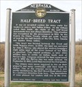
| Half Breed Tract in Nebraska Historical Markers This marker stands near lands set aside for descendants of early fur traders and local Indian tribes. posted by: NevaP location: Nebraska date approved: 11/24/2007 last visited: 09/10/2020 |
 view gallery view gallery W14 km W14 km
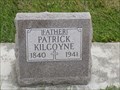
|  100 - Patrick Kilcoyne - Holy Cross Cemetery - Nemaha Co., NE 100 - Patrick Kilcoyne - Holy Cross Cemetery - Nemaha Co., NE
in Headstones of Centenarians Centenarian Patrick Kilcoyne is buried at Holy Cross Cemetery posted by: Max and 99 location: Nebraska date approved: 10/30/2019 last visited: never |
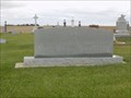 view gallery view galleryW14 km |  Holy Cross Cemetery - Nemaha County, Nebraska, USA Holy Cross Cemetery - Nemaha County, Nebraska, USA
in Worldwide Cemeteries Holy Cross Cemetery is located on Highway 75 in Nemaha County, NE posted by: Max and 99 location: Nebraska date approved: 10/30/2019 last visited: never |
 view gallery view galleryW14.5 km |  Subway - Auburn, NE Subway - Auburn, NE
in Subway Restaurants Subway #13822 is in the Crestview Shopping Center at 2322 Dahlke Ave,
Auburn, NE. Phone is 402-274-3030. posted by: QuarrellaDeVil location: Nebraska date approved: 06/05/2020 last visited: never |
 view gallery view galleryNW15 km |  1890 - New Opera House - Auburn, Nebraska 1890 - New Opera House - Auburn, Nebraska
in Dated Buildings and Cornerstones Historic former opera house/auditorium in Auburn, Nebraska. posted by: BruceS location: Nebraska date approved: 12/07/2008 last visited: 11/26/2013 |
 view gallery view galleryNW15 km | New Opera House - Auburn, Nebraska in U.S. National Register of Historic Places Historic former opera house/auditorium in Auburn, Nebraska. posted by: BruceS location: Nebraska date approved: 12/07/2008 last visited: 06/08/2014 |
 view gallery view galleryNW15 km |  Legion Memorial Park Bandshell - Auburn, Nebraska Legion Memorial Park Bandshell - Auburn, Nebraska
in Bandshells Bandshell in city park in Auburn, Nebraska. posted by: BruceS location: Nebraska date approved: 12/07/2008 last visited: 07/20/2014 |
|