 view gallery view gallery S10.6 km S10.6 km
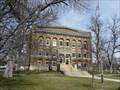
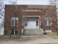
|   Webster County Courthouse, Red Cloud, Nebraska Webster County Courthouse, Red Cloud, Nebraska
in Courthouses Webster County's courthouse was built in 1914. posted by:  NevaP NevaP location: Nebraska date approved: 04/18/2008 last visited: never |
 view gallery view galleryS10.6 km |  Webster County courthouse Webster County courthouse
in U.S. National Register of Historic Places Webster County's Second Renaissance Revival style courthouse was built in 1914. posted by: NevaP location: Nebraska date approved: 04/19/2008 last visited: never |
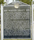 view gallery view galleryS10.6 km |  Webster County Webster County
in Nebraska Historical Markers This marker relates history of Webster County. posted by: NevaP location: Nebraska date approved: 04/18/2008 last visited: never |
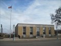 view gallery view galleryS10.8 km |  Red Cloud NE Post Office - 68970 Red Cloud NE Post Office - 68970
in U.S. Post Offices This post office is located at 310 N Webster St in the small town of Red Cloud, NE which is in Webster County. posted by:  VQ9JC VQ9JC location: Nebraska date approved: 08/24/2013 last visited: never |
 view gallery view galleryS10.9 km |  Starke Round Barn Starke Round Barn
in Barns This is the largest round barn in Nebraska and one of the largest in the United States. posted by: NevaP location: Nebraska date approved: 04/19/2008 last visited: 08/04/2016 |
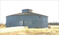 view gallery view galleryS10.9 km | Starke Round Barn in U.S. National Register of Historic Places This is the largest round barn in Nebraska and one of the largest in the United States.
posted by: NevaP location: Nebraska date approved: 04/19/2008 last visited: never |
 view gallery view gallery W26.2 km W26.2 km
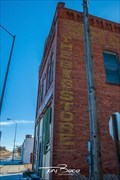
|  The Big Store - Riverton, NE The Big Store - Riverton, NE
in Ghost Signs Located on the west side of a brick building. posted by: mr.volkswagen location: Nebraska date approved: 03/04/2020 last visited: never |
 view gallery view gallery N29.9 km N29.9 km
| KINGSTON CEMETERY in Nebraska Historical Markers The Kingston Cemetery is located on the hill just west of this marker. posted by: plainsdrifter358 location: Nebraska date approved: 05/29/2008 last visited: 04/12/2023 |
 view gallery view gallery NE34.9 km NE34.9 km
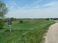
| SPRING RANCHE in Nebraska Historical Markers The original Spring Ranche, located two miles south of here on the north side of the Little Blue River, was founded about 1863. posted by: plainsdrifter358 location: Nebraska date approved: 05/30/2008 last visited: 05/14/2007 |
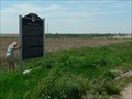
 view gallery view galleryN38.1 km |  32 Mile Creek Station 32 Mile Creek Station
in Pony Express Monuments A Pony Express memorial to the Thirty-Two Mile Creek Stage and Pony Express Station. posted by:  GravRidr GravRidr location: Nebraska date approved: 10/19/2009 last visited: 09/19/2014 |
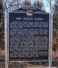 view gallery view galleryNE38.5 km | 1864 Indian Raids in Nebraska Historical Markers This marker tells of Indian raids on the Oregon trail in 1864. posted by: NevaP location: Nebraska date approved: 02/26/2007 last visited: 04/12/2023 |
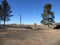
 view gallery view galleryS39.6 km |  Geographic Center of Lower 48 States of America Geographic Center of Lower 48 States of America
in Geographical Centers 1st Geographic Center of the Lower 48 States of America near Lebanon Kansas posted by: GEO*Trailblazer 1 location: Kansas date approved: 07/19/2007 last visited: 05/11/2021 |
 view gallery view galleryS39.6 km |  GEOGRAPHIC CENTER 1 GEOGRAPHIC CENTER 1
in Kansas Historical Markers GEOGRAPHIC CENTER OF THE NATION 1 posted by: GEO*Trailblazer 1 location: Kansas date approved: 10/18/2006 last visited: 07/07/2022 |
 view gallery view galleryS39.6 km |  Geographic Center of US -- nr Lebanon KS Geographic Center of US -- nr Lebanon KS
in Welcome Signs An artistically-carved welcome sign in local Post Rock limestone welcomes visitors to the small park around the geographic center of the US. posted by: Benchmark Blasterz location: Kansas date approved: 04/20/2013 last visited: 07/07/2022 |
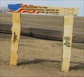 view gallery view galleryS39.6 km |  Geographic Center -- nr Lebanon KS Geographic Center -- nr Lebanon KS
in Artistic Welcome Signs An artistically-carved beautifully rendered welcome sign in local Post Rock limestone greets visitors to the small park at the geographic center of the US. posted by: Benchmark Blasterz location: Kansas date approved: 04/20/2013 last visited: 08/07/2020 |
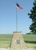
 view gallery view galleryS40.1 km |  N 39° 50 W 098° 35 - Lebanon KS N 39° 50 W 098° 35 - Lebanon KS
in Permanent Geographic Coordinates A plaque on the monument marking the Geographic Center of the United States (the lower 48; long before Alaska and Hawaii joined the Union). posted by: PeterNoG location: Kansas date approved: 06/27/2009 last visited: 05/11/2021 |
 view gallery view galleryS40.1 km |  Geographic center of the contiguous United States Geographic center of the contiguous United States
in Wikipedia Entries Located near the center of the lower 48 are several monuments and memorials. posted by: ChapterhouseInc location: Kansas date approved: 01/26/2014 last visited: 08/07/2020 |
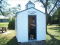 view gallery view galleryS40.1 km |  US Center Chapel - Kansas US Center Chapel - Kansas
in Waychapels Welcome to the Center of the United States of America. posted by: mr.volkswagen location: Kansas date approved: 07/17/2007 last visited: 07/07/2022 |
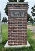 view gallery view galleryW40.9 km |  Greenwood Cemetery - Franklin, NE Greenwood Cemetery - Franklin, NE
in Worldwide Cemeteries Greenwood Cemetery is just northeast of Franklin, Nebraska. posted by: The Snowdog location: Nebraska date approved: 01/10/2021 last visited: never |
 view gallery view galleryW40.9 km |  John C. Brumbaugh - Franklin, NE John C. Brumbaugh - Franklin, NE
in Woodmen of the World Grave Markers/Monuments John C. Brumbaugh was a Woodman of the World; in Greenwood Cemetery, Franklin, Nebraska. posted by: The Snowdog location: Nebraska date approved: 01/11/2021 last visited: never |
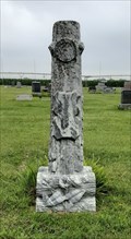
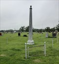 view gallery view galleryW40.9 km |  Greenwood Cemetery Obelisk - Franklin, NE Greenwood Cemetery Obelisk - Franklin, NE
in Obelisks This uninscribed obelisk is enclosed within a chain fence in Greenwood Cemetery, Franklin, Nebraska. posted by: The Snowdog location: Nebraska date approved: 02/09/2021 last visited: never |
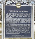 view gallery view galleryW41.5 km | Franklin Academy in Nebraska Historical Markers The marker, in the Franklin City Park, is about a church affiliated academy which operated at this location from 1881 to 1922. posted by: NevaP location: Nebraska date approved: 04/18/2008 last visited: never |
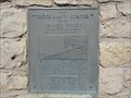
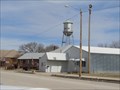 view gallery view galleryS41.7 km |  KG0664 Lebanon Municipal tank -- Lebanon KS KG0664 Lebanon Municipal tank -- Lebanon KS
in U.S. Benchmarks The Lebanon Municipal tank serves the water needs of this snmall KS town. It is also NGS benchmark KG0664. posted by: Benchmark Blasterz location: Kansas date approved: 04/20/2013 last visited: 08/07/2020 |
 view gallery view galleryS41.7 km |  Lebanon Municipal Tank -- Lebanon KS Lebanon Municipal Tank -- Lebanon KS
in Water Towers The Lebanon Municipal tank serves the water needs of this snmall KS town. It is also NGS benchmark KG0664. posted by: Benchmark Blasterz location: Kansas date approved: 04/20/2013 last visited: 08/07/2020 |
 view gallery view galleryS41.7 km |  Lebanon KS Lebanon KS
in City and Town Halls The Prairie-style city hall for tiny Lebanon KS (population 218) has been serving this small town since it was built in 1924. posted by: Benchmark Blasterz location: Kansas date approved: 04/20/2013 last visited: 08/07/2020 |
|