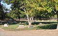
 view gallery view gallery E19.2 km E19.2 km
|   Camp Lassen Camp Lassen
in Boy Scout Camps Owned by the Golden Empire Council, Camp Lassen is located forty-five minutes east of Chico off Highway 32 near Butte Meadows, California. posted by:  heringermr heringermr location: California date approved: 07/23/2007 last visited: never |
 view gallery view gallery SW24.1 km SW24.1 km
|  Vina Cemetery Vina Cemetery
in Worldwide Cemeteries This small cemetery is located several miles northeast of the small town of Vina. posted by:  brwhiz brwhiz location: California date approved: 11/29/2013 last visited: never |
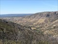 view gallery view gallery N27.4 km N27.4 km
|  Battle Creek Vista Point - California Battle Creek Vista Point - California
in Scenic Roadside Look-Outs The Battle Creek Vista Point along Calif. Hwy. 36. posted by: Volcanoguy location: California date approved: 12/25/2013 last visited: 09/18/2013 |
 view gallery view gallery NW28 km NW28 km
|  Paynes Creek, California 96075 Paynes Creek, California 96075
in U.S. Post Offices This Post Office is attached to the Paynes Creek Store located at 29791 Paynes Creek Loop in Paynes Creek, California. posted by: brwhiz location: California date approved: 10/30/2013 last visited: never |
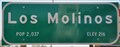
 view gallery view gallery W28.5 km W28.5 km
|  Los Molinos ~ Population 2,037 Los Molinos ~ Population 2,037
in Population Signs This combination Elevation/Population sign is on Railroad Avenue/Golden State Highway/California Highway 99 at the northern city limits of Los Molinos. posted by: brwhiz location: California date approved: 11/14/2013 last visited: never |
 view gallery view galleryW28.5 km |  Los Molinos ~ Elevation 216 Los Molinos ~ Elevation 216
in Elevation Signs This combination Elevation/Population sign is on Railroad Avenue/Golden State Highway/California Highway 99 at the northern city limits of Los Molinos. posted by: brwhiz location: California date approved: 11/14/2013 last visited: never |
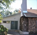
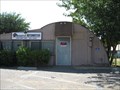 view gallery view galleryW28.6 km |  Los Molinos Quonset Hut - Los Molinos, CA Los Molinos Quonset Hut - Los Molinos, CA
in Quonset Huts A quonset hut on Hway 99 in Los Molinos, CA. The building is currently up for sale. posted by: saopaulo1 location: California date approved: 08/11/2010 last visited: 09/13/2010 |
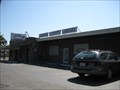 view gallery view galleryW28.6 km |  Los Molinos Branch - Tehama County Library - Los Molinos, CA Los Molinos Branch - Tehama County Library - Los Molinos, CA
in Libraries The Los Molinos branch is one of three that make up the Tehama County branch. The library is on Hway 99. posted by: saopaulo1 location: California date approved: 08/12/2010 last visited: 09/13/2010 |
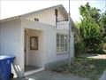
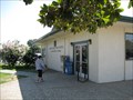 view gallery view galleryW28.6 km | Los Molinos, CA - 96055 in U.S. Post Offices The Los Molinos post office on Hway 99 in Los Molinos, CA. posted by: saopaulo1 location: California date approved: 08/13/2010 last visited: 09/13/2010 |
 view gallery view galleryW28.8 km | Los Molinos ~ Elevation 216 in Elevation Signs This combination Elevation/Population sign is on Golden State Highway/California Highway 99 at the southern city limits of Los Molinos. posted by: brwhiz location: California date approved: 11/14/2013 last visited: never |
 view gallery view galleryW28.8 km | Los Molinos ~ Population 2,037 in Population Signs This combination Elevation/Population sign is on Golden State Highway/California Highway 99 at the southern city limits of Los Molinos. posted by: brwhiz location: California date approved: 11/14/2013 last visited: never |
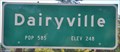
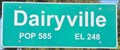 view gallery view galleryW29.1 km | Dairyville ~ Population 585 in Population Signs This combination Elevation/Population sign is on Golden State Highway/California Highway 99 at the southern city limits of Dairyville. posted by: brwhiz location: California date approved: 11/14/2013 last visited: never |
 view gallery view galleryW29.1 km | Dairyville ~ Elevation 248 in Elevation Signs This combination Elevation/Population sign is on Golden State Highway/California Highway 99 at the southern city limits of Dairyville. posted by: brwhiz location: California date approved: 11/14/2013 last visited: never |
 view gallery view galleryW29.6 km | Dairyville ~ Elevation 248 in Elevation Signs This combination Elevation/Population sign is on Golden State Highway/California Highway 99 at the northern city limits of Dairyville. posted by: brwhiz location: California date approved: 11/14/2013 last visited: never |
 view gallery view galleryW29.6 km | Dairyville ~ Population 585 in Population Signs This combination Elevation/Population sign is on Golden State Highway/California Highway 99 at the northern city limits of Dairyville. posted by: brwhiz location: California date approved: 11/14/2013 last visited: never |
 view gallery view gallerySW29.8 km |  OLDEST - building on the West Coast of US OLDEST - building on the West Coast of US
in Superlatives Santa Maria de Ovila was relocated from Spain and rebuilt in Northern Calif. as New Clairvaux. The Spanish government closed all religious orders in 1835. In 1931, posted by: sbcamper location: California date approved: 06/15/2013 last visited: 10/04/2013 |
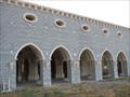 view gallery view gallerySW29.8 km |  Santa Maria de Ovila Monastery / New Clairvaux - Vina CA Santa Maria de Ovila Monastery / New Clairvaux - Vina CA
in Medieval Churches This Gothic church was moved from Spain in 1931. It was not reconstructed until after 1955. It belongs to the New Clairvaux Abbey of Cisterian, Trappist monks. posted by: sbcamper location: California date approved: 07/08/2013 last visited: 10/04/2013 |
 view gallery view gallerySW29.8 km |  Santa Maria de Ovila Monastery / New Clairvaux - Vina CA Santa Maria de Ovila Monastery / New Clairvaux - Vina CA
in Relocated Structures This special building was first erected in Spain and later moved to Vina, CA. posted by: Queens Blessing location: California date approved: 12/15/2013 last visited: 12/16/2013 |
 view gallery view gallerySW30.1 km |  Vina Community Church - Vina CA Vina Community Church - Vina CA
in Bell Towers This is a classic church in a very small town. posted by: sbcamper location: California date approved: 06/22/2013 last visited: never |
 view gallery view gallerySW30.3 km | Vina, CA - 96092 in U.S. Post Offices A post office in the small community of Vina, CA. posted by: saopaulo1 location: California date approved: 08/13/2010 last visited: 10/04/2013 |
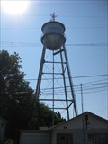 view gallery view galleryW30.3 km |  Tehama Water Tower - Tehama, CA Tehama Water Tower - Tehama, CA
in Water Towers The Tehama water tower over Tehama's city hall. The city's name is written on the tower. posted by: saopaulo1 location: California date approved: 08/11/2010 last visited: 09/13/2010 |
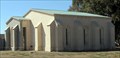
 view gallery view galleryW30.3 km |  Tehama, CA Tehama, CA
in City and Town Halls The city hall for Tehama, CA. posted by: saopaulo1 location: California date approved: 08/21/2010 last visited: 09/13/2010 |
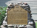 view gallery view galleryW30.3 km |  FIRST - Seat of Tehama County Government - Tehama, CA FIRST - Seat of Tehama County Government - Tehama, CA
in First of its Kind Plaque marking the first seat of Tehama County Government posted by: saopaulo1 location: California date approved: 08/16/2010 last visited: 08/16/2010 |
 view gallery view galleryW30.3 km |  First Tehama County Courthouse - Tehama, CA First Tehama County Courthouse - Tehama, CA
in California Historical Markers A California Plaque in Tehama, CA. posted by: saopaulo1 location: California date approved: 08/14/2010 last visited: 09/13/2010 |
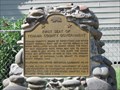 view gallery view galleryW30.3 km |  First Seat of Tehama County Government - Tehama, CA First Seat of Tehama County Government - Tehama, CA
in E Clampus Vitus Historical Markers An ECV/CHL plaque in Tehama, CA. posted by: saopaulo1 location: California date approved: 08/11/2010 last visited: 08/16/2010 |
|