 view gallery view gallery NW0.3 km NW0.3 km
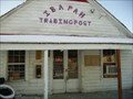
|   Ibapah Trading Post Ibapah Trading Post
in Payphones Working Payphone located at the Ibapah Trading post in Ibapah Utah. There is no cell service here so this is the only link to the outside world. posted by:  caverspencer caverspencer location: Utah date approved: 02/25/2007 last visited: never |
 view gallery view gallery E15.3 km E15.3 km
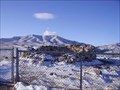
|  Canyon Station Canyon Station
in Pony Express Monuments Canyon Station Ruins located in Overland Canyon near Ibapah, Utah posted by: caverspencer location: Utah date approved: 02/16/2007 last visited: 11/30/2008 |
 view gallery view gallery NE19.3 km NE19.3 km
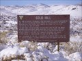
|  Gold Hill, Utah Gold Hill, Utah
in Ghost Towns Gold Hill posted by: caverspencer location: Utah date approved: 02/16/2007 last visited: never |
 view gallery view gallery W54.6 km W54.6 km
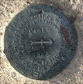
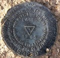
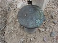
|  LQ0655 - USCGS LAGES NO 1 - 1965 - Nevada LQ0655 - USCGS LAGES NO 1 - 1965 - Nevada
in U.S. Benchmarks U.S. Coast & Geodetic Survey reference mark LAGES NO 1. posted by:  Volcanoguy Volcanoguy location: Nevada date approved: 12/24/2016 last visited: 09/28/2016 |
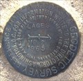
 view gallery view galleryW54.6 km | LQ0655 - USCGS LAGES - 1965 - Nevada in U.S. Benchmarks U.S. Coast & Geodetic Survey triangulation station LAGES. posted by: Volcanoguy location: Nevada date approved: 12/24/2016 last visited: 09/28/2016 |
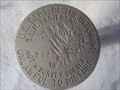
 view gallery view galleryW54.6 km | LQ0655 - USCGS LAGES NO 2 - 1965 - Nevada in U.S. Benchmarks U.S. Coast & Geodetic Survey reference mark LAGES NO 2. posted by: Volcanoguy location: Nevada date approved: 12/24/2016 last visited: 09/28/2016 |
 view gallery view gallery SW62.3 km SW62.3 km
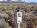
| Schellbourne Pass in Pony Express Monuments Pony Express route marker at Schellbourne Pass, Nevada. posted by: Volcanoguy location: Nevada date approved: 01/17/2017 last visited: 09/29/2016 |
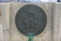
 view gallery view gallerySW62.4 km | Schellbourne Pass, Nevada in U.S. Benchmarks Located on the original route of the Pony Express posted by:  Uncle Alaska Uncle Alaska location: Nevada date approved: 12/12/2005 last visited: 09/29/2016 |
 view gallery view gallery S64.9 km S64.9 km
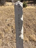
| U. S. Cadastral Survey Marker - Gandy, Utah in U.S. Benchmarks Another Benchmark at a fence corner in Gandy, Utah. posted by: JacobBarlow location: Utah date approved: 09/18/2007 last visited: 09/19/2007 |
 view gallery view galleryS64.9 km | Cadastral Survey Marker - Gandy, Utah in U.S. Benchmarks The Benchmark is at a fence corner in Gandy, Utah. posted by: JacobBarlow location: Utah date approved: 09/18/2007 last visited: 09/19/2007 |
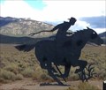 view gallery view galleryW69.8 km |  Unknown - U.S. Hwy. 93, Nevada, USA Unknown - U.S. Hwy. 93, Nevada, USA
in Silhouette Public Art Sculptures Silhouette sculpture of a Pony Express Rider along U.S. Hwy. 93. posted by: Volcanoguy location: Nevada date approved: 12/31/2016 last visited: 04/09/2021 |
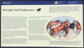 view gallery view galleryW69.8 km |  Strength And Endurance Strength And Endurance
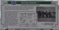
in Nevada Historical Markers Pony Express history sign at the Schellbourne Rest Area. posted by: Volcanoguy location: Nevada date approved: 12/31/2016 last visited: 04/09/2021 |
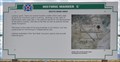
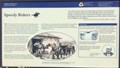 view gallery view galleryW69.8 km | Speedy Riders in Nevada Historical Markers Pony Express history sign at the Schellbourne Rest Area. posted by: Volcanoguy location: Nevada date approved: 12/31/2016 last visited: 04/09/2021 |
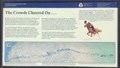 view gallery view galleryW69.8 km | The Crowds Cheered On . . . in Nevada Historical Markers Pony Express history sign at the Schellbourne Rest Area. posted by: Volcanoguy location: Nevada date approved: 12/31/2016 last visited: 04/09/2021 |
 view gallery view galleryW69.8 km |  Lincoln Highway Marker - Schellbourne, NV (Repro) Lincoln Highway Marker - Schellbourne, NV (Repro)
in Lincoln Highway Markers Found at a rest area along hwy 93 posted by: Uncle Alaska location: Nevada date approved: 12/12/2005 last visited: 04/09/2021 |
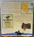 view gallery view galleryW69.8 km | THE PONY EXPRESS: A Journey Across the American West in Nevada Historical Markers Pony Express history sign at the Schellbourne Rest Area. posted by: Volcanoguy location: Nevada date approved: 12/31/2016 last visited: 04/09/2021 |
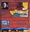 view gallery view galleryW69.8 km | THE LINCOLN HIGHWAY: A Vision that Spanned America in Nevada Historical Markers Lincoln Highway history sign at the Schellbourne Rest Area. posted by: Volcanoguy location: Nevada date approved: 01/07/2017 last visited: 09/29/2016 |
 view gallery view galleryW69.8 km | SCHELLBOURNE: Gateway to the Goshute Nation in Nevada Historical Markers Goshute Indian Nation history sign at the Schellbourne Rest Area. posted by: Volcanoguy location: Nevada date approved: 01/07/2017 last visited: 09/29/2016 |
 view gallery view galleryW69.8 km |  Schellbourne Rest Area Schellbourne Rest Area
in Highway Rest Areas Schellbourne Rest Area on U.S. Hwy. 93. posted by: Volcanoguy location: Nevada date approved: 01/02/2017 last visited: 09/29/2016 |
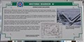
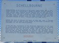 view gallery view galleryW70 km | Schellbourne in Nevada Historical Markers Nevada Historical Marker Number 51 is located in the Schellbourne Rest Area at the northeast corner of the junction of US Highway 93 and Wyoming Highway 893 about 38.5 miles north of Ely, Nevada. posted by: brwhiz location: Nevada date approved: 08/31/2013 last visited: 04/09/2021 |
 view gallery view galleryW70 km | Highway 93 Nevada Monument in Pony Express Monuments This is where the Pony Express trail crosses Highway 93. posted by: redheadsrule location: Nevada date approved: 01/19/2006 last visited: 04/09/2021 |
 view gallery view gallery N76.9 km N76.9 km
|  Hangar 835 and Fire Station Area Hangar 835 and Fire Station Area
in Utah Historical Markers This is Stop "I" on the self-guided walking/driving tour of the Wendover Air Force Base from which the mission to drop the first atomic bomb originated. A brochure detailing the complete tour is available at the Base Museum, 345 S Airport Apron. posted by: brwhiz location: Utah date approved: 10/03/2012 last visited: 09/01/2018 |
 view gallery view galleryN76.9 km | South Base Area in Utah Historical Markers This is Stop "C" on the self-guided walking/driving tour of the Wendover Air Force Base from which the mission to drop the first atomic bomb originated. A brochure detailing the complete tour is available at the Base Museum, 345 S Airport Apron. posted by: brwhiz location: Utah date approved: 10/02/2012 last visited: 03/10/2019 |
 view gallery view galleryN76.9 km | Operations Building in Utah Historical Markers This is Stop "A" on the self-guided walking/driving tour of the Wendover Air Force Base from which the mission to drop the first atomic bomb originated. A brochure detailing the complete tour is available at the Base Museum, 345 S Airport Apron. posted by: brwhiz location: Utah date approved: 10/03/2012 last visited: 03/10/2019 |
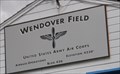 view gallery view galleryN76.9 km |  Wendover Air Base ~ Elevation 4230 Wendover Air Base ~ Elevation 4230
in Elevation Signs This Elevation Sign is on the south side of the Wendover Airport Operations Building facing the aircraft apron. posted by: brwhiz location: Utah date approved: 10/03/2012 last visited: 03/10/2019 |
|