 view gallery view gallery NW1.4 km NW1.4 km
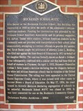
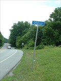
|   Hockessin School #107C (NC-137) - Hockessin, DE Hockessin School #107C (NC-137) - Hockessin, DE
in Delaware Historical Markers Hockessin School #107-C posted by:  prm prm location: Delaware date approved: 04/12/2006 last visited: never |
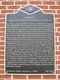 view gallery view galleryNW1.4 km | CHIPPEY (NC-140) - Hockessin, DE in Delaware Historical Markers Chippey, African Union Methodist Church, DE marker NC-140 posted by: prm location: Delaware date approved: 04/13/2006 last visited: never |
 view gallery view gallery N1.4 km N1.4 km
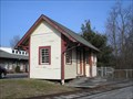
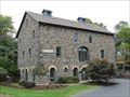
|  Hockessin Station - Hockessin, Delaware Hockessin Station - Hockessin, Delaware
in Train Stations/Depots This small depot began life in Kennedyville, Maryland, was moved to Greenbank Delaware, and finally arrived in Hockessin, Delaware. posted by: Bluejacket01 location: Delaware date approved: 07/08/2010 last visited: never |
 view gallery view galleryNW1.8 km |  Dunkin' Donuts - Lancaster Pike - Hockessin, DE Dunkin' Donuts - Lancaster Pike - Hockessin, DE
in Dunkin Donuts' A Dunkin' Donuts in Hockessin, Delaware. posted by: bluesnote location: Delaware date approved: 10/09/2019 last visited: 10/09/2019 |
 view gallery view galleryNW1.8 km |  Prima's Pizza & Pasta - Hockessin, DE Prima's Pizza & Pasta - Hockessin, DE
in Independent Pizza Restaurants A pizza restaurant in Hockessin, Delaware. posted by: bluesnote location: Delaware date approved: 09/07/2019 last visited: 09/07/2019 |
 view gallery view gallery W2.1 km W2.1 km
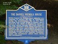
| The Daniel Nichols House (NC-228) - Hockessin, DE in Delaware Historical Markers British General Sir William Howe embarked on a campaign to capture the city of Philadelphia during the Revolutionary War in 1777. The marker is located on Limestone Drive at Sheringham Drive, Hockessin DE, 19707. posted by:  Don.Morfe Don.Morfe location: Delaware date approved: 09/24/2019 last visited: 10/23/2021 |
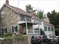
 view gallery view galleryW2.1 km |  Daniel Nichols House-Mill Creek Hundred - Hockessin DE Daniel Nichols House-Mill Creek Hundred - Hockessin DE
in Battlefields British General Sir William Howe and his army passed through Mill Creek Hundred. The army ransacked farms taking livestock and supplies. The house served as Howe’s headquarters. posted by: Don.Morfe location: Delaware date approved: 09/19/2020 last visited: 10/17/2021 |
 view gallery view gallery SW2.1 km SW2.1 km
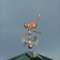
|  Kitten Weather Vane Kitten Weather Vane
in Unique Weathervanes A kitty chasing some mice! posted by: ODragon location: Delaware date approved: 09/07/2007 last visited: 03/11/2012 |
 view gallery view gallery E2.4 km E2.4 km
| Saint Mary's Church (NC-32) - Hockessin, DE in Delaware Historical Markers Site of the first Catholic church in Delaware, Usually called "Coffee Run" Church. The marker is located at 7200 Lancaster Pike, Hockessin, DE, 19707 posted by: Don.Morfe location: Delaware date approved: 09/24/2019 last visited: 10/23/2021 |
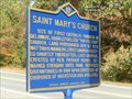 view gallery view galleryE2.4 km |  FIRST - Catholic Church in Delaware-Saint Mary's Church - Hockessin DE FIRST - Catholic Church in Delaware-Saint Mary's Church - Hockessin DE
in First of its Kind Site of the first Catholic church in Delaware, Usually called "Coffee Run" Church. The marker is located at 7200 Lancaster Pike, Hockessin, DE, 19707 posted by: Don.Morfe location: Delaware date approved: 11/21/2022 last visited: 03/21/2023 |
 view gallery view gallery S2.7 km S2.7 km
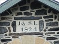
|  1824 - J. Lindsay Barn - Newark, Delaware 1824 - J. Lindsay Barn - Newark, Delaware
in Dated Buildings and Cornerstones Historic barn near Newark Delaware. posted by:  BruceS BruceS location: Delaware date approved: 03/15/2015 last visited: never |
 view gallery view galleryS2.7 km |  J. Lindsay Barn – Newark, Delaware J. Lindsay Barn – Newark, Delaware
in Wikipedia Entries Historic barn near Newark Delaware. posted by: BruceS location: Delaware date approved: 03/14/2015 last visited: never |
 view gallery view galleryS2.7 km |  Lindsay, J., Barn – Newark, Delaware Lindsay, J., Barn – Newark, Delaware
in U.S. National Register of Historic Places Historic barn near Newark Delaware. posted by: BruceS location: Delaware date approved: 03/16/2015 last visited: never |
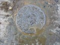 view gallery view galleryNW3.2 km |  USGS “PENNSYLVANIA”, Delaware-Pennsylvania USGS “PENNSYLVANIA”, Delaware-Pennsylvania
in U.S. Benchmarks USGS “PENNSYLVANIA” is a bench mark disk mounted in the top of a dressed gneiss stone, set in 1892, that marks the DE-PA state boundary line along Delaware’s circular northern boundary with Pennsylvania. posted by: seventhings location: Delaware date approved: 09/25/2007 last visited: never |
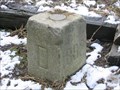 view gallery view galleryNW3.2 km |  USCGS 12-Mile Circle Mile 6, 1893, Delaware-Pennsylvania USCGS 12-Mile Circle Mile 6, 1893, Delaware-Pennsylvania
in U.S. Historic Survey Stones and Monuments USCGS 12-Mile Circle Mile 6, 1982, DE-PA, is a dressed gneiss stone that marks the DE-PA state boundary line along Delaware’s circular northern boundary with Pennsylvania. posted by: seventhings location: Delaware date approved: 09/25/2007 last visited: never |
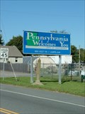
 view gallery view galleryNW3.2 km |  Pennsylvania Welcomes You - Kaolin, PA Pennsylvania Welcomes You - Kaolin, PA
in Welcome Signs A Pennsylvania welcome sign located in highway 41. posted by: bluesnote location: Pennsylvania date approved: 09/27/2019 last visited: 09/27/2019 |
 view gallery view galleryNW3.2 km |  Delaware/Pennsylvania Border at DE/PA 41 Delaware/Pennsylvania Border at DE/PA 41
in Border Crossings Delaware/Pennsylvania State Border Crossing NW of Wilmington. posted by: Ernmark location: Delaware date approved: 10/18/2008 last visited: 09/01/2019 |
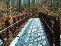 view gallery view galleryS3.4 km |  Weather Hill Park Pedestrian Bridge Weather Hill Park Pedestrian Bridge
in Truss Bridges Pedestrian Bridge in Weather Hill Park. posted by: Brianslost location: Delaware date approved: 02/09/2007 last visited: never |
 view gallery view galleryW3.5 km | Delaware / Pennsylvania Crossing at DE 7 / Limestone RD in Border Crossings Border crossing & Northern terminus of DE Route 7 - just S of the intersection of Limestone RD & Southwood RD. posted by: Ernmark location: Pennsylvania date approved: 07/11/2011 last visited: 08/28/2011 |
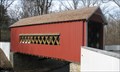 view gallery view galleryE4.3 km |  Wooddale Covered Bridge - Wilmington, DE Wooddale Covered Bridge - Wilmington, DE
in Covered Bridges The Wooddale Covered Bridge is 60 feet... posted by: ODragon location: Delaware date approved: 04/02/2009 last visited: 03/12/2011 |
 view gallery view gallerySW4.5 km | Robert Graham House – Newark, Delaware in Wikipedia Entries Historic house near Newark Delaware. posted by: BruceS location: Delaware date approved: 03/14/2015 last visited: never |
 view gallery view gallerySW4.5 km | Graham, Robert, House – Newark, Delaware in U.S. National Register of Historic Places Historic house near Newark Delaware. posted by: BruceS location: Delaware date approved: 03/16/2015 last visited: never |
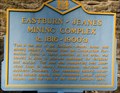 view gallery view gallerySW4.7 km | Eastburn-Jeanes Mining Complex (NC-83) - Newark, DE in Delaware Historical Markers EASTBURN-JEANES MINING COMPLEX posted by: ODragon location: Delaware date approved: 04/03/2009 last visited: never |
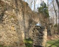 view gallery view gallerySW4.7 km |  Eastburn-Jeanes Mining Complex - Newark, De Eastburn-Jeanes Mining Complex - Newark, De
in Ovens and Kilns EASTBURN-JEANES MINING COMPLEX posted by: ODragon location: Delaware date approved: 04/03/2009 last visited: never |
 view gallery view gallery SE5 km SE5 km
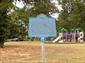
| Camp DuPont (NC 79) - Wilmington, DE in Delaware Historical Markers The Fourth Regiment Delaware Volunteer Infantry camped here June to October 1862. The marker is located on Faulkland Road at the intersection of W. Oakland Drive, Wilmington DE 19808 in Brandywine Springs Park. posted by: Don.Morfe location: Delaware date approved: 10/01/2019 last visited: 10/23/2021 |
|