 view gallery view gallery E17.9 km E17.9 km
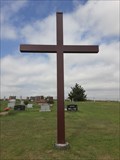
|   Trinity First Lutheran Cemetery Cross - Stuttgart, KS Trinity First Lutheran Cemetery Cross - Stuttgart, KS
in Churchyard Crosses This plain steel Christian cross is at the northeast corner of Trinity First Lutheran Cemetery in Stuttgart, Kansas. posted by:  The Snowdog The Snowdog location: Kansas date approved: 01/18/2021 last visited: never |
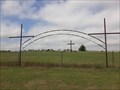 view gallery view galleryE17.9 km |  Trinity First Lutheran Cemetery - Stuttgart, KS Trinity First Lutheran Cemetery - Stuttgart, KS
in Worldwide Cemeteries Trinity First Lutheran Cemetery is on the south side of Highway 36 just west of Stuttgart, Kansas. posted by: The Snowdog location: Kansas date approved: 01/18/2021 last visited: never |
 view gallery view gallery NW18.8 km NW18.8 km
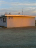
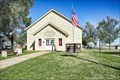
|  KQNK FM 106.7 & AM 1530 KQNK FM 106.7 & AM 1530
in A.M./F.M. Radio Broadcasting Stations This is Norton's local radio station. It plays "Classic Rock" and it's highlight is "The Party Line" every week-day starting at 9:00a. posted by:  gpboutwell gpboutwell location: Kansas date approved: 03/06/2009 last visited: never |
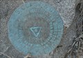
 view gallery view gallery W19.3 km W19.3 km
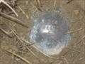
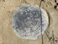
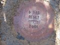
|  NGS M 364 RESET 1998, Kansas NGS M 364 RESET 1998, Kansas
in U.S. Benchmarks NGS M 364 RESET 1998, KS, is a Vertical Control Mark located about 0.1 miles south of the intersection of US Highway 283 and Road T about eight miles south of Norton, Norton County, KS. posted by: seventhings location: Kansas date approved: 05/31/2006 last visited: never |
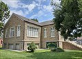 view gallery view galleryNW20.6 km |  Norton County Historical Museum - Norton, KS Norton County Historical Museum - Norton, KS
in History Museums The Norton County Historical Museum is housed in the old Norton Public Library in Norton, Kansas. posted by: The Snowdog location: Kansas date approved: 01/07/2021 last visited: never |
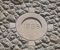 view gallery view galleryNW20.6 km |  1938 - Norton Public Library, Norton, KS 1938 - Norton Public Library, Norton, KS
in Dated Buildings and Cornerstones The Norton Public Library building was constructed in 1938 - in Norton, Kansas. posted by: The Snowdog location: Kansas date approved: 01/07/2021 last visited: never |
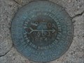
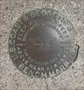 view gallery view galleryNW20.6 km | NORTON 1933 - Norton, KS in U.S. Benchmarks This U.S. Coast and Geodetic Survey benchmark disk is near the old Norton Public Library; in Norton, Kansas. posted by: The Snowdog location: Kansas date approved: 01/08/2021 last visited: 03/07/2022 |
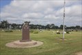
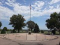 view gallery view galleryNW21.1 km |  Norton Veterans Memorial - Norton, KS Norton Veterans Memorial - Norton, KS
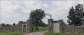
in Non-Specific Veteran Memorials This veterans memorial is the centerpiece of Norton Cemetery, on the northwest side of Norton, Kansas. posted by: The Snowdog location: Kansas date approved: 01/09/2021 last visited: never |
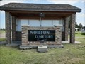 view gallery view galleryNW21.2 km | Norton Cemetery - Norton, KS in Worldwide Cemeteries This large cemetery is on the north side of Norton, Kansas. posted by: The Snowdog location: Kansas date approved: 01/09/2021 last visited: never |
 view gallery view galleryNW21.4 km | KG0827: Norton Municipal Tank - Norton KS in U.S. Benchmarks This Benchmark is the Water Tower on Warsaw Street and Jones Avenue in Norton, Kansas. posted by: PeterNoG location: Kansas date approved: 09/29/2013 last visited: 03/07/2022 |
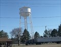 view gallery view galleryNW21.4 km |  Water Tower - Norton KS Water Tower - Norton KS
in Water Towers This Water Tower is at Warsaw Street and Jones Avenue in Norton, Kansas. posted by: PeterNoG location: Kansas date approved: 10/01/2013 last visited: 03/07/2022 |
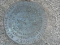 view gallery view galleryNW21.4 km | KG0518: NORTON RM2 - Norton KS in U.S. Benchmarks This Benchmark is 60 feet southwest of the Water Tower on Warsaw Street and Jones Avenue in Norton, Kansas. posted by: PeterNoG location: Kansas date approved: 12/24/2013 last visited: 08/06/2020 |
 view gallery view galleryNW21.4 km | KG0518: NORTON RM1 - Norton KS in U.S. Benchmarks This Benchmark is 60 feet northwest of the Water Tower on Warsaw Street and Jones Avenue in Norton, Kansas. posted by: PeterNoG location: Kansas date approved: 12/24/2013 last visited: 08/06/2020 |
 view gallery view galleryNW21.4 km | KG0518: NORTON - Norton KS in U.S. Benchmarks This Benchmark is just west of the Water Tower on Warsaw Street and Jones Avenue in Norton, Kansas. posted by: PeterNoG location: Kansas date approved: 09/29/2013 last visited: 03/07/2022 |
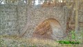 view gallery view galleryE28.5 km |  Phillipsburg City Park Pedestrian Stone Bridge - Phillipsburg, KS Phillipsburg City Park Pedestrian Stone Bridge - Phillipsburg, KS
in Stone Bridges This pedestrian bridge goes from the Phillipsburg City park up to the Fort Bissell Campground. posted by: mr.volkswagen location: Kansas date approved: 11/11/2015 last visited: never |
 view gallery view galleryE28.5 km |  Phillipsburg City Park Pedestrian Stone Bridge - Phillipsburg, KS Phillipsburg City Park Pedestrian Stone Bridge - Phillipsburg, KS
in WPA Projects Located in the Phillipsburg City Park across from the restrooms and parking area. posted by: mr.volkswagen location: Kansas date approved: 11/12/2015 last visited: never |
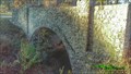 view gallery view galleryE28.6 km | Phillipsburg CityPark Road Stone Bridge - Phillipsburg, KS in WPA Projects Located in the Phillipsburg City Park. You drive over this bridge to get to the campground on the hill. posted by: mr.volkswagen location: Kansas date approved: 11/12/2015 last visited: never |
 view gallery view galleryE28.6 km | Phillipsburg CityPark Road Stone Bridge - Phillipsburg, CO in Stone Bridges Located in the Phillipsburg City Park. You drive over this bridge to get to the campground on the hill. posted by: mr.volkswagen location: Colorado date approved: 11/19/2015 last visited: never |
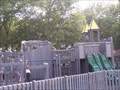 view gallery view galleryE28.6 km |  Phillipsburg City Park - Phillipsburg, KS Phillipsburg City Park - Phillipsburg, KS
in Public Playgrounds Park is located at west end of Phillipsburg. posted by: mr.volkswagen location: Kansas date approved: 07/18/2007 last visited: never |
 view gallery view galleryE30.6 km | Philipsburg Veterans Memorial - Philipsburg, KS in Non-Specific Veteran Memorials This simple veterans memorial is in the center of Fairview Cemetery in southeast Philipsburg, Kansas. posted by: The Snowdog location: Kansas date approved: 02/06/2021 last visited: never |
 view gallery view galleryE30.7 km | Fairview Cemetery - Philipsburg, KS in Worldwide Cemeteries Fairview Cemetery, final rest for about five thousand souls, is in southeast Philipsburg, Kansas. posted by: The Snowdog location: Kansas date approved: 01/17/2021 last visited: never |
 view gallery view gallery SW38.5 km SW38.5 km
| NGS X 11 RESET 2004, Kansas in U.S. Benchmarks NGS X 11 RESET 2004, KS, is a Vertical Control Mark located at the intersection of US Highway 283 and V Road about five miles north of Hill City, Graham County, KS. posted by: seventhings location: Kansas date approved: 05/31/2006 last visited: never |
 view gallery view gallery S40.6 km S40.6 km
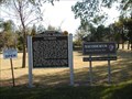
|  Nicodemus Nicodemus
in Kansas Historical Markers The town of Nicodemus was a planned community devoted to Black settlement in the years after the U.S. Civil War. posted by: Kansas Stasher location: Kansas date approved: 10/21/2006 last visited: 05/10/2023 |
 view gallery view galleryS40.7 km |  Nicodemus Historic District - Nicodemus KS Nicodemus Historic District - Nicodemus KS
in U.S. National Register of Historic Places Nicodemus National Historic Site, located in Nicodemus, Kansas, United States, preserves, protects and interprets the only remaining western town established by African Americans during the Reconstruction Period following the American Civil War. posted by: nomadwillie location: Kansas date approved: 07/16/2018 last visited: 05/10/2023 |
 view gallery view galleryS41.5 km | NGS G 365 RESET 2004, Kansas in U.S. Benchmarks NGS G 365 RESET 2004, KS, is a Vertical Control Mark located near the intersection of US Highway 283 and T Road about three miles north of Hill City, Graham County, KS. posted by: seventhings location: Kansas date approved: 05/31/2006 last visited: never |
|